Algonquin Provincial Park
September 11-18, 2010
The route we followed is sometimes referred to as the Hogan Lake Loop which begins and ends at the village of Brent in the northernmost part of Algonquin Park. It was intended to be a less strenuous and perhaps safer lake-to-lake trip, but turned out to be surprisingly arduous. The portages were very long and the September weather was cold and wet. On the other hand, the scenery was beautiful and mushrooms festooned the landscape. This journal was a collaborative effort, but the narrative voice ("I") is Jim Brown's. (In this journal, "Jim" refers to Jim Fuhrman.)
Preparations
The trials and tribulations of trying to plan an easier canoe trip while attempting to coordinate the schedules and accommodate the predilections of four people.
Where can four 60-somethings (all having recently recovered from some injury or malady) go on a reasonably challenging week-long canoe trip without overtaxing their stamina or risking re-injury? That was the question. Clambering over slippery rocks to scout rapids or traversing lengthy portages carrying 80+ pound canoes and heavy packs did not seem like the right choice.
In a way, the preparations for the resulting trip were almost as dramatic as the trip itself especially the process of deciding where and when to go. Larry first brought up the matter at the end of August 2009 and suggested an April trip on the Buffalo (Arkansas - very easy) or a May trip on the Namekagon (Wisconsin - moderate). But most of the discussion about the trip took place around Christmas and a few weeks after.
Other than the difficulty/risk factor, the main issue was my transportation constraints. With only two vehicles in the family, and both in use by Emily and Chris for commuting to work, I had no straightforward means of getting to the Cincinnati area (for the Buffalo) or to Chicago (for the Namekagon) until the end of the schoolyear in mid-June, when Emily would no longer need a vehicle. But Larry was not available in June or July, and by August the water levels would be too low for either of the suggested river trips. Ironically, as I remarked at the time, the most workable trip for me would seem to be on a string of Canadian lakes (sort of like the Sakatawi route) in mid-September. 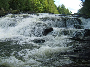 The conditions would be somewhat better (cooler, no bugs); lake travel would minimize the impact of low water levels; the semester would just be starting, so Emily's need for teaching assistance would be minimal; and with the crew stopping by my house, I would not need a vehicle. But such an alternative was not even on the radar before. Does it make any sense now?
The initial answer was Maybe but not at the expense of an easier and probably more fun trip on the Buffalo in late April. The initial decision, then, was to go ahead with the Buffalo trip but without me and later discussion would determine whether to mount a Canadian trip in September.
However, only a few days later (11 January), Larry unveiled a surprise: This is a bit unexpected, but canoe trip plans have changed again. I conferred with Rob and JF over the weekend and we have collectively decided to abandon plans to canoe on the Buffalo in April and instead do a lake-to-lake trip in the Algonquin during the week of September 12 - 18. That week is open and convenient for the three of us and is preferable in many respects to the April dates.
And just like that, the trip was set. We still had to work out many logistical details the most dramatic of which involved a decision to rent lightweight Kevlar canoes from an outfitter in Algonquin rather than using our own canoes (Larrys Old Town Tripper and my Old Town Penobscot, both of which weigh about 80 pounds) and Larrys trailer to transport them. Despite the extra expense, this decision would prove crucial not only for our own ability to endure the extensive portaging in Algonquin, but also for the ability of Larrys Honda Element to complete the drive to and from Algonquin.
Going
Travel to Jim Brown's house; brunch by Emily; north to Huntsville; supper at the "Moose."
Larry left home at 6:30AM, picking up Rob at 6:45 and Jim at around 7:00. After a relatively uneventful drive through Ohio into Michigan and a stop for gas just north of Ann Arbor, he turned the wheel over to Rob, then called me on his cell phone at around noon to let me know they were approaching Brighton on US-23. They arrived at my house shortly before 12:30. Just moments later, Tara Young (Chriss girlfriend) and her son Ryan arrived. (Chris, Tara, and Ryan were planning to drive to Grand Rapids that afternoon.) Emily had moved our van over to the other side of the garden, but with so many vehicles, the driveway still looked like a crowded parking lot.
Emily had prepared a substantial brunch for the crew: spinach soufflé, hash browns, fruit salad, etc. Fortified with that meal, the crew departed my house at 1:30. To avoid construction on I-696 north of Detroit, we decided to take US-23 north to Flint, then I-69 east to Port Huron. But in Michigan theres no escaping construction during the ice-free months. Even on I-69 we encountered barrels, narrowed lanes, and reduced speeds. Fortunately, there were no delays crossing the border bridge from Port Huron to Sarnia. Evidently Canada is not as obsessed with security as we are in the U.S.
In the later afternoon, we stopped for gas at a small town between London and Toronto where I took over the driving from Rob. We arrived at Huntsville at around 7:30PM and checked in to the Travelodge where Larry had made reservations.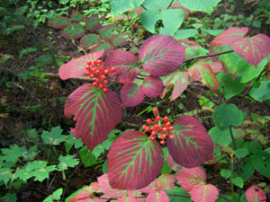 Larry and I ended up on the third floor, Rob and Jim on the first. The accommodations were relatively Spartan, but measured against the camping we would do the next night, this motel was downright luxurious!
After plopping our bags in our respective rooms, we headed into downtown Huntsville for dinner. On the way, we noticed a banner across the main street welcoming triathletes to the Muskoka Triathlon. We werent sure what that meant, so we resolved to ask about it when we had the chance. After passing a couple of restaurants, we stopped at a Petro Canada to refuel the Honda. Surprisingly, the pumps were not self-serve. Larry was at the wheel, and the woman pumping gas for us engaged him in a rather loopy conversation from which he concluded that she might be stoned. But he did manage to extract from her the best place to have dinner. She recommended the Moose Moose Delaneys Bar & Grill which we had not seen, but was apparently back toward the motel.
After driving past it a couple times, we finally found the Moose a distinctly Canadian pub. We ended up with a very young waitress (possibly a high school student) whom Rob described as dumb mostly because she had to tell him the bar was out of certain martini ingredients (like olives). For dinner, Larry had Tilapia, Rob had wings, and Jim and I had salads (knowing we would be without fresh greens for a week) although I also had a side-order of sweet potato fries to share with the crew.
During the meal, we agreed to get up early the next morning and meet at 7:00 to go to breakfast. Returning then to the motel, we watched news on TV, then went to bed at around 11PM. Overnight rainshowers did not bode well for camping conditions, but we hoped they were part of a narrow front that would soon pass.
Day 1 Sunday, 12 September
Breakfast in Huntsville; on to North Bay; in search of fishing licenses; Mr. Sub; stop at Brent Crater; the outfitter in Brent; paddle across Cedar Lake; portage to the Petawawa River and the eyeglasses disaster; reconnoitering downstream; campsite near a waterfall at the end of the second portage; setting up camp and suspending the food pack; campfire and a cool evening.
Rising at about 6:15AM, we checked the morning news and weather on TV. The short-term forecast included rain, but longer-term looked more promising.
Since we did not expect to have a source of clean water at any of our campsites, we decided to fill our water canisters, canteens, etc. with the motels tapwater. That would save us from having to filter water for the first day or so in the park. Also, since the park does not allow glass containers, I took the opportunity to transfer my Woodford Reserve Bourbon (which Larry had acquired for me during a liquor run into Kentucky) from its bottle to a stainless steel Kleen Kanteen newly purchased from Campmor.
As agreed, we went looking for breakfast at around 7AM and found it at Louis II right on the main drag. This restaurant featured great service and plenty of good food at excellent prices. During the meal, we asked the waitress about the triathlon. Apparently the race itself was to be held at a lake outside town, and the sign on the main street was aimed at participants who might be lodging or dining in town prior to the event.
After breakfast, Jim took the wheel and drove northeast from Huntsville to North Bay (on Lake Nipissing). There we started looking for a place to buy fishing licenses. According to our contacts so far (waitress, service station attendant, motel manager), the licenses were available at an odd assortment of businesses, such as tire stores and pet stores, but those were not likely to be open on Sunday, even if we could find them. We checked at a Wal-Mart and a Home Hardware that happened to be open, then finally learned that Hilltop Variety Store sold fishing licenses. (Evidently, these licenses were just part of the variety that included greeting cards, Clamato, dry cleaning, etc.) Larry and I waited patiently at the hardware store while Rob and Jim walked just down the road to get the licenses. For six days of fishing, the cost was a jaw-dropping $48 per license! Needless to say, we all hoped for a substantial return on that investment in the form of several fresh fish dinners, or at very least in the form of recreational enjoyment. As usual, Larry viewed the matter with bemused skepticism, but even he could hardly have imagined how sadly our fishing aspirations would be disappointed!
Once the fishing licenses were in hand, Larry suggested that we go across the street to a Mr. Sub to buy sandwiches to save for lunch or dinner once we reached the outfitter. He had been advised that food options were very limited in Brent. 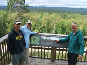 Everyone agreed since it would be difficult to scare up a meal in the expected flurry of activity at the outfitter or in the initial hours of paddling and portaging. Larry and Rob bought subs with fairly traditional ingredients like ham and cheese, but Jim and I decided to try something different, so he went for a tuna sub and I for a seafood sub. Both turned out to be mistakes. His tuna was too dry, while my seafood mixture was just the opposite: a runny mess that ended up staining the clothing in my bag and (even days later) straining the pit of my stomach!
From North Bay, Larry drove us to the tiny town of Brent, location of Algonquin Outfitters. Along the winding 25-mile park road into Brent, we stopped first at park headquarters to pay for our camping permits. Oddly, the receipts identified the source of the permits as Bourgeois Contracting of Deux Rivieres so evidently this governmental function had been outsourced to a private contractor.
About halfway down the gravel road and in the middle of nowhere, the engine warning light on the Honda came on, raising a new concern for us. For now, though, we assumed that the warning was just caused by the failure of the gas attendant in Huntsville to close the gas cap properly. In any event, we were not going to let this issue interfere with our trip we would deal with it upon our return.
A bit farther down the road we stopped at the storied Brent Crater to scale a tower overlooking the meteor crater. The tower was nice enough, with an impressive view of the surroundings, but after 450 million years of erosion, we found it impossible to discern the contours of the crater. (Perhaps the contours would be more visible once the leaves had fallen, but at this point, the trees were just beginning to hint at their autumn colors.)
We reached Brent at around 1PM. 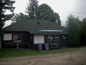 Somewhat alarmingly, the outfitter store was closed, but we found the proprietors around back, and they promptly opened the store for us. After we paid our canoe rental fees, I noticed a sale price on some North 49 shoes that were apparently designed for both wading and portaging. I had planned to take along a pair of old neoprene water shoes for use in the canoe and also a pair of well-used running shoes for the portage trail. (Around the campsite I expected to wear Teva sandals.) But switching back and forth between the two would be a time-consuming hassle. These shoes would solve that problem, so I promptly decided to buy a pair and left the other shoes back in the Honda.
Once we completed all our store transactions, we hauled our gear down to the outfitters dock on Cedar Lake. There we were provided with two Swift Kipawa Kevlar canoes lightweight (about 45 pounds) with a length of 16 6. Unfortunately, the wooden yokes were too broad and contoured for Larrys yoke pads to fit. We were pleased at how light the canoes were, but not being able to use those yoke pads would prove to be a real drawback on the longer portages.
Once we were set to launch, we paused for a short while on a picnic bench behind the store to eat our subs. Mine had been partially squashed in my bag and was oozing fishy-smelling liquid into some of my clothing. The taste was OK, but the mouth feel was not appealing, and I regretted having passed up a more traditional meat sub. Jim complained that his tuna sub had the dryness and consistency of sawdust. Already we were not happy campers!
Finally we launched into Cedar Lake at around 2:30. Larry took the stern and Rob the bow in one canoe; Jim took the bow and I the stern in the other. Except for a few brief exceptions, we kept these configurations for the whole trip. It was cloudy and threatening rain. A stiff wind was blowing from the southwest, producing substantial waves, but they were partly behind us at an angle, so we made pretty good time across the lake. 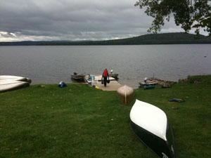 We were thrilled to see and hear loons for the first time in many years. Rain squalls hit us about halfway across the lake, so we donned our rain gear for the first but certainly not the last time.
Portage #1: Cedar Lake to Petawawa River (715 meters)
Our landing was at the start of the portage trail on the left around rapids that looked like a gentle cascade down a long slope into the lake. Also, just above the lake and to the left of the trail was a large and inviting camping area. We briefly discussed whether to camp here this evening, but really wanted to get farther into the park and away from signs of civilization, however meager they might be at this point, so we decided to push on. The portage distance seemed less than expected, maybe because we were in good spirits at finally having started the canoeing. Larry and I portaged the canoes this first time.
Toward the end of the portage trail we noticed a wooden cross inscribed I.H.S. / A. Corbeil / 1 June 1888. Later we learned that Corbeil had been a logger, but nothing else was known about him, including his first name and how he had died. (This artifact recalled the cross we had encountered at Angler Falls on our White River trip back in 1989. That guy had died running the rapids in 1975 probably by inadvertently missing the portage whereas Corbeil had presumably died in a logging accident.)
We certainly expected no such tragedies on this trip, but still, this portage turned out to be the site of our first significant mishap. While climbing the first major incline of the trail with the canoe, Larry, who was still wearing his rain jacket and fleece due to the inclement weather, became overheated. Docking the canoe on a canoe rest at the midway point of the trail, he proceeded to remove the heavy outergarments. His glasses somehow ended up on the ground, and he accidently stepped on them, leaving them mangled and without one of the lenses. Without glasses he would have trouble on both the water and the trails, but more importantly, he would not be able to consult his topographical maps effectively enough to keep us from straying off course in the irregularly shaped lakes with their many islands. We decided that while he and Jim worked on fixing the glasses, Rob and I would paddle to the next portage and see whether the campsite there was worth taking. Although we really didnt expect much competition for campsites this late in the season, we also didnt want to waste time cruising around looking for open sites, so we took along one portage pack to leave as a means of laying claim to the campsite.
Portage #2: Petawawa River (255 meters)
After a two-mile paddle, Rob and I reached the portage on the right around rapids and a waterfall. We hiked to the end of the trail, where we found a pleasant campsite within earshot of the rapids. We immediately decided to recommend staying here, so we left our site claim pack and headed back to Larry and Jim.
On hiking and paddling back to the first portage, we found that Larry and Jim had devised a way to fix the glasses, had then finished portaging the gear, and were now awaiting our report as to the availability and condition of the next campsite. They welcomed our good news but were less enthusiastic about the amount of time our reconnaissance had taken.
Loading the canoes with our remaining gear, we paddled back to the second portage, completed the portage, and then left the canoes overturned on the riverbank below camp. The packs and gear we hauled up a fairly steep embankment into the campsite, and then we surveyed the site for spots where the tents could be erected. 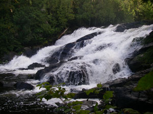 As pleasant as the campsite looked (and sounded), we found, on closer inspection, that there were no level tent sites. Every prospective site was sloping and/or riddled with roots and rocks. We resigned ourselves to sleeping in some discomfort that night and began setting up camp at around 6PM.
Our tent arrangements turned out to be just the opposite of our canoe configuration: Larry and I slept in his Mountain Hardware 3-man tent the whole trip, while Rob and Jim slept in Jims Eureka 3-man tent. We had decided not to use my L.L. Bean tent which is quite roomy and has vestibules at both ends because its heavier, almost a 4-man tent. Larrys pentagonal tent with sophisticated windowed vestibule proved to be fairly complicated to set up, and for the rest of the trip, we always seemed to have difficulty lining up the components especially the four supporting poles in exactly the right positions.
While Jim and Rob set up their tent, Larry and I decided to take photos of the rapids/falls while we still had light. Light would, in fact, be an issue for this trip. Unlike our previous trips which had been in late spring or early summer, when days were longest (shortly before of after summer solstice) we were approaching autumn now, and darkness would fall by 7:30PM.
On the other hand, this trip provided us with a pleasant surprise: all established campsites were provided with latrines featuring a standardized design! Each latrine was set back from the campsite with plenty of shielding evergreens for relative privacy, but reachable by an easy-to-follow trail. The latrine itself consisted of a pit toilet with a large wooden box above ground and ventilation slits on the side. The hole and the entire top surface of the box were protected by a hinged lid checked by a chain doorstop. The box faced away from the campsite, so that when the lid was up, it provided additional privacy.
Fortunately, the earlier rains had given way to sunny, but cool weather. We were able to enjoy Happy Hour and dinner around a crackling fire.
Unlike the Crown Lands we were used to, Algonquin is a park with a greater likelihood of bear encounters, so we had been advised to hoist our food out of bear reach every night. Larry found a good strong branch, but perhaps as a result of Happy Hour, he was having some trouble sending a rope up over the branch. I finally managed to do it by bundling the rope. As a result, I was elected the official rope-thrower for setting up the nightly food hoist a somewhat dubious honor.
By the campfire, I used my Therm-a-rest seat strap for the first time (another recent Campmor purchase), but found that my pre-trip attempts to patch leaks in the Therm-a-rest had not worked, as the mattress kept deflating. 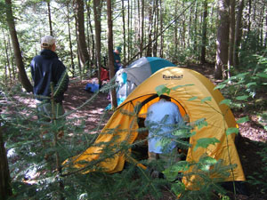 This did not bode well for my sleeping arrangements that night. Larry had brought along two Therm-a-rests a full-sized mattress like mine and a smaller one and he offered to loan me one for additional cushioning. I gladly accepted.
After the day of driving, paddling, and portaging, we were all pretty tired, so we retired to the tents fairly early, around 10:00. By that time the air had become surprisingly cold, and we shuddered to think how frigid the conditions would be by dawn. Even so, we were pleased to find a complete absence of mosquitoes almost enough by itself to vindicate our decision to locate the trip in September.
Despite the unlevel and somewhat lumpy tent sites, we were quickly lulled to sleep by the white noise from the nearby rapids. At one point during the night, Rob shifted suddenly in his sleep, alarming Jim, who thought it might be a bear sniffing at their tent. At around 3AM, a brisk wind erupted, bringing some rain showers. We thought these showers were the last gasp of a front that had passed to the east. Little did we realize they would represent the prevailing weather pattern for the entire week!
Day 2 Monday, 13 September
Late start; longest portage of the trip around Stack Rapids; encounter with Canadian paddlers on the trail; portage to Narrowbag Lake through a road crossing; short portage to Catfish Lake and lunch; paddle south on Catfish Lake to windy peninsula campsite; cold, wind, and rain by the fire.
The whole crew rose at around 8AM. Everything was damp from the earlier rain, but the air was not as cold as expected. Evidently the rain had come with a (relatively) warm front. Fog drifted into camp from the river, but hints at blue skies above suggested that the sun would burn off the fog later in the morning.
Because of the wet conditions and time constraints, we used Larrys stove to boil water for coffee and breakfast foods rather than trying to build a morning fire. That became our modus operandi for the rest of the trip, even on the rare dry mornings.
As on past trips, our efforts to get through the first morning in camp were awkward and uncoordinated. Eventually a familiar rhythm and routine would fall into place, but for the time being the only thing to do was muddle through. In fits and starts we cleaned up the campsite, took down the tents, packed the gear, and were ready to launch the canoes at around 11AM.
As we set out, the sun was starting to peek through the haze above, dissipating the fog. Weather reports from the previous day had indicated the rain would last only into Monday, leaving the rest of the week sunny and dry, so the clearing conditions seemed to be going according to script.
Although we were headed upstream at this point, the current on the Petawawa River was pretty sluggish, so we soon reached our next portage, the longest one of the trip.
Portage #3 - Petawawa River (2345 meters)
This portage, which took us to the left around Stacks Rapids, called for a long, gradual climb up Unicorn Hill. 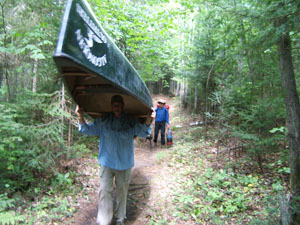 Fortunately, five canoe rests were spaced about 400-500 meters apart along the portage trail. We used three of them. At the halfway point, we encountered a party of three Canadians heading downstream. We stopped to chat for a while. They were just returning from a trip over the same circle route we were beginning. Most of the discussion centered on the length and difficulty of the trail and a comparison with the trail from Hogan Lake to Manta Lake, which they assured us (to our chagrin) was much more arduous than the one we were currently struggling over. One mentioned that he would be portaging a kayak on his next pass. Evidently the kayak limited his vision more than a canoe, so he warned us to alert him to our presence if we encountered him on the trail.
After pausing briefly at the next canoe rest, we completed the portage at around 1:30. As we rested and snacked at the campsite located at the end of the portage trail, another canoeist trudged into the clearing and dropped his load with a gasp and a "That's a long trail!" He and his buddy were headed for Catfish Lake, where they planned to camp a few days and fish. Realizing that we were potentially in the way of this new party, we wearily rose to our feet and loaded our canoes for the short paddle to the next portage.
Portage #4: Petawawa River to Narrowbag Lake (170 meters)
This portage avoids a waterfall and rapids to the east. The trail crosses an old road that was presumably used for logging maybe not long ago, because timbers engraved with Caution: Road Crossing are embedded in the trail on either side of the road bed. The trail was fairly easy, especially when compared to the last one, and we were soon loaded up on the other side and headed out into Narrowbag Lake which, as the name suggests, is longer than it is wide. Rain clouds and rising winds were menacing from the north, and we anticipated a downpour. The paddle down the lake took about an hour, and we fortunately encountered only moderate rainfall as we reached the take-out point.
Portage #5: Narrowbag Lake to Catfish Lake (80 meters)
This short portage took us past rapids that looked as if they might be runnable with higher water levels, although the jagged remains of a dam or bridge spanning the upper end of the chute created an additional impediment. 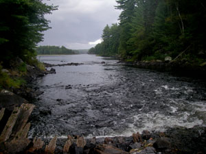 We stopped for lunch on the bluff overlooking the trail terminus and the rocky rapids. It continued to sprinkle, and heavier rains were visible in the near distance coming up behind us. Also coming up behind us and through the rain were two canoes, so we soon embarked once again.
Catfish Lake is a big lake, but does not seem so because the watery expanses are interrupted by so many large, irregular peninsulas and islands. On the return trip, these misleading features would prove to be quite vexing, but on the way in, they presented only a modest challenge to Larrys navigational skills. The major challenges at this point were strong winds, falling temperatures, and weariness from the day's significant portaging.
At one point, we passed an island known as Turtle Rock without realizing it had once been a place of worship for the local Native Americans. Just beyond was Shangri La Island, where we wanted to camp. But someone else had that campsite, so we were forced to take a campsite on a peninsular just east of the island. This peninsula was almost an island itself much larger, but just barely connected to the mainland to the east. Our campsite at the west-most tip of the peninsula provided little shelter from the prevailing westerly winds across the lake.
We enjoyed a bit of late afternoon sunshine, but the skies gradually clouded over again, and it became increasingly obvious that the weather was not going to behave according to script. At least we managed to reach the campsite before any significant rain arrived. The campsite presented a large slab of rock tapering into the lake. The most obvious landing was buffeted by wind, but just around the point was a modest beach where we were able to pull the canoes ashore without battling waves or dragging the hulls across rock.
The rain began with an outright gale as we were setting up the tents. Rob had set his sunglasses on a crude table wedged between a couple of trees, but the wind blew them to the ground near where Larry and I were setting up our tent. Presumably one of us stepped on them, because Rob later found them somewhat mangled. We also thought the wind had blown away the pole bag for our tent, and we spent some time that evening and the next morning looking for the bag in the surrounding underbrush before we eventually found it underneath the tent while breaking camp.
One of the nicest features of this campsite was a fireplace rocks neatly stacked at least two feet high in a circle, with an opening for the hearth. Given our exposed position and the high winds, a campfire would have been impossible without the sheltering rocks. As a hedge against further rain, we set up a tarp over the fireplace and kitchen area. It was a chilly evening, and we all donned fleece under rain gear or otherwise dressed as warmly as possible. 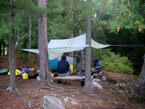 The only exception was Jim, whose rain gear, a meager poncho, offered no insulating value. Also, due to a shortage of warm clothing, he continued to wear shorts, attempting to protect his only pair of long pants from the rain. His only footwear on this trip was a pair of sandals which were sturdy enough, but did not offer much protection from the three-Rs on the portage trails (roots, rocks, ruts) or from the cold. Perhaps that is why he and Rob retired early to the warmth of their sleeping bags.
Larry and I stayed by the campfire for another hour until the flames died down. At that point, we hoisted the food pack on the sturdy limb of a large tree we had found near the latrine, then retired to the tent. The rain tapered off, but then returned later with more gusts of wind. Catfish Lake seemed to have an abundant loon population, and we noticed that the loons tended to call out whenever the wind started up almost as if warning us about the next wave of rain.
Day 3 Tuesday, 14 September
Purifying water in the morning; paddle to the southwest end of Catfish Lake; portage around Catfish Rapids; portage around Snowshoe Rapids; wilderness "throne;" short portage and a profusion of mushrooms; portage around Cedar Rapids; portage to Burntroot Lake; lunch near an old cabin; encounter with a paddling trio with a wood strip canoe; paddle across Burntroot Lake to Redpine Lake with deteriorating weather; setting up camp in cold and wet conditions; primitive "kitchen;" a belated fire.
Arising around 7AM, the crew was greeted with overcast, damp conditions and a temperature in the mid-40s. Our morning routine was similar to the previous day, although possibly a bit more efficient.
By now most of us had run out of the water we had obtained at the motel in Huntsville, so we resorted to using our pump filters. A week before the trip, I had bought a First Need Water Purifier from Campmor, but Id never actually tested it. I was a little apprehensive about using it now for the first time, but my concern proved to be unfounded. The device was easy to use and worked perfectly, churning out a quart of purified water in less than a minute. In short order, I filled my canteen and two water bottles enough water for the rest of the day in this cool, damp weather. Everyone except Rob had their own water purifier, although Larry's subsequently failed. Ironically, both Rob and Larry ended up relying on Jim's purifier throughout the trip despite the apparent efficiency advantage of the First Need.
At some point, we brought up the fact that Jims wife, Emily, would be celebrating her birthday today without Jim, of course. Unfortunately, we were too far out in the middle of nowhere for cell phone reception, so he would just have to wish her a happy birthday after the fact. Today was also the birthday of my son, Chris, so I, too, would have to wait till after the trip to wish a happy birthday.
This morning we managed to break camp by 10:00 and were soon paddling southwest toward the narrows of lower Catfish Lake. After a relatively quiet start to the day, the wind had begun to pick up from the west, and we had to contend with waves slapping against the gunnels. But patches of blue appeared among the clouds a hint of more promising weather.
After about an hour of paddling, we reached the marshy southernmost tip of the lake where our route began its loop. In three days, we expected to complete the loop by paddling to this same spot from Sunfish Lake, which lay somewhere through the heavy reeds to our southeast. Today, we began the loop by paddling into the narrowing channel to our southwest. We could hear the rapids around which we expected to portage upstream along the Petawawa River.
Portage #6: Catfish Lake to Petawawa River (365 meters)
This portage was on the right around Catfish Rapids. Near the end of the portage was a short trail leading into a small campsite on the right. We nearly missed it because the trail was so overgrown, evidently from lack of use. A few seating logs were strategically placed around a fire ring, so we paused there briefly for snacks. Then we proceeded expeditiously, loading up the canoes again in short order and paddling upstream for two miles to the next portage.
Portage #7: Petawawa River (320 meters)
This portage was on the left around Snowshoe Rapids. At the end, to the left of the trail, we found a fairly large campsite with more strategically placed logs and, curiously enough, a crude throne hand-carved from a large stump. This unique artifact gave rise to speculations about its age and origin. Evidently a canoeist, fisherman, or logger with time on his hands perhaps wind-bound or otherwise confined to camp by especially bad weather had decided to try his hand at home improvement of a sort. Although we had just stopped for snacks at the previous portage, Rob insisted on trying out this marvel of technology, despite its uninviting damp surface, so we paused again for snacks before loading up and launching the canoes.
Portage #8: Petawawa River (90 meters)
This portage took us to the right past a swift (a rock-strewn narrows). As short as this trail was, it featured an amazing profusion of mushroom species. Actually, all the trails we had traversed so far seemed to have this common element: a prolific menagerie of mushrooms in all shapes and colors much to Robs delight, as he is an ardent shroomer, especially in the spring, when he hunts for whatever morels he can find in Ohio. Unfortunately, this was not the right time for morels, and no one in the group was competent to discern which of the local fungi might be edible. Still, if there was a theme to this trip other than long portages and too much rain, it was the beauty, variety, and abundance of mushrooms in so many places. Certainly, their beauty made for interest as we tramped along laden with canoes and gear, but sadly, we were so busy portaging and dealing with the elements that we took little time to fully appreciate or even photograph this natural wonder.
Portage #9: Petawawa River to Perley Lake (420 meters)
This portage was on the right around Cedar Rapids. There was a campsite near the beginning, but otherwise there was nothing particularly noteworthy about the trail.
Portage #10: Perley Lake to Burntroot Lake (155 meters)
This portage was on the left around Portal Rapids. We had lunch at the campsite near the end of the trail. The cool wind was changeable and pretty strong; plus there was occasional rain. 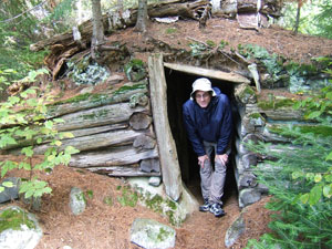 We were glad to wait out some of the passing squalls before embarking on the lake. Just beyond the campsite down a short trail, we discovered an old cabin (or perhaps an elaborate root cellar). The structure appeared to be usable as a temporary shelter from the elements. We spent some time climbing on top of the structure, exploring the area behind it, and taking photos inside and out.
When we returned to the end of the portage trail, we encountered a small party with a wooden canoe a magnificent-looking vessel! The guy had built it himself not from a kit, but from plans he had obtained by mail-order. We were amazed to hear that the canoe weighed only 55 pounds! He and his wife (or maybe girlfriend) were traveling with a male friend. It was not clear how all three could fit into this one canoe, but then, we had managed to fit three, plus a weeks worth of gear and supplies, into Larrys Tripper on our Sakatawi and White River trips. Although we enjoyed talking with this trio, we were concerned that we would be bumping into them at portages and vying with them for campsites. But they informed us they would be portaging from Burntroot Lake over to another lake which was not on our route.
From this portage, we headed south into the open expanse of Burntroot Lake. Whistle Bay, which was off to the west, supposedly had several island campsites, but we werent quite ready to camp yet. It wasnt long, though, before the weather changed our minds. So far it had been fairly pleasant, even though the skies had never cleared up. But now rain started tentatively, the wind picked up, and the air turned colder. The skies began to look threatening enough that we decided to start looking for a campsite. Anchor Island in the center of the lake was supposed to have a nice campsite, but as we approached the island, we could see signs of someone already camped there. We checked out a campsite on a point east of the island, but decided the access was too steep.
Continuing through the open section of the lake, we had to contend with fairly big waves coming at us from the southwest. Eventually we entered a narrower section of the lake with some shelter from the wind. This channel connected to Red Pine Lake (also known as Red Pine Bay), which was actually our projected destination for the day. There were supposed to be several campsites along this stretch, but nothing really stood out.
As we entered the main body of Red Pine Lake, the wind became stronger again. Conditions were deteriorating so quickly that we decided to head straight across to the southern lakeshore where several campsites were supposed to be located. Jim and I started counterclockwise around a small island that we thought looked promising for a campsite. Meanwhile, Larry and Rob headed for a more certain campsite along the shore. We saw no sign of a campsite on the island, so we broke off our circle when Rob and Larry motioned for us to come check out the shore campsite. This site looked unappealing due to its difficult access, but we spotted a better site on a wooded peninsula just to the southeast. At this point the wind and rain really started to pick up, so Jim and I paused in the meager shelter of the shoreline trees for Jim to don his poncho, while Larry and Rob paddled through the driving rain to the proposed campsite. By the time we joined them, we were all cold and wet, but Jim was alarmingly so shivering uncontrollably!
Larry immediately recognized the danger of hypothermia and emphasized that we needed to put up a tarp right away, set up Jims tent under the tarps protection, then get Jim into the tent as quickly as possible, where he could change into warm, dry clothes. 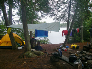 That sequence became our urgent priority. Eventually we set up Larrys tent the same way, and everyone took some time inside the tents to recover from the miserable conditions.
During the struggle to put up tarp and tents, I noticed that my fingers were not working well almost as if they were frozen. They werent numb although they had an electrical tingle to them but they seemed to have lost all fine motor strength and coordination. This problem would continue on and off for the rest of the trip, even when I was paddling. (A subsequent visit to the doctor would reveal that the culprit was a vitamin B-12 deficiency.)
Now that the rudiments of camp were in place for this dank evening, our next order of business was to get some hot food into everyone. The rain continued, and conditions were too wet for a campfire, so we used Larrys stove to boil water for dinner while we huddled under the tarp. Our kitchen consisted of a primitive table comprised of a small slab of slate balanced on a stump. It was here that Rob proposed to start splitting the dinners differently. Instead of splitting two dinners four ways, he and Jim would share one dinner, and Larry and I would share the other. What we lost in variety we would gain in efficiency, more even distribution of portions, and warmer food. In these conditions, the prospect of warmer food would have been a major selling point regardless of what we ate! Thus the proposal was accepted without dissent. For tonight, Rob and Jim would eat Chili Mac, while Larry and I would eat Hawaiian Chicken.
In the fading light, we noticed that the island Jim and I had mostly circled did indeed have a campsite. We would have seen it if we had continued another 50 meters. On the other hand, we would have seen it right away if we had just circled the island in the opposite direction. However, there was no reason to think that campsite would have been any better than the one we were in now. In fact, the miserable weather was a great equalizer, rendering every campsite in the area equally unpleasant!
We crawled back into the tents after dinner to avoid the rain and to attempt to get warm. Amazingly, the rain stopped about 30 minutes later, and even more amazingly, we were able to get a fire going with the wet wood. 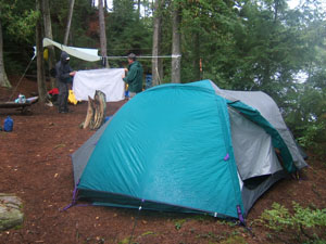 The warmth was particularly welcomed by Jim, who had been chilled to the bone. We did not stay around the fire for long, however, as it was still quite cold, and more rain threatened. Everyone was so cold and tired that we retired to the tents without hoisting the food pack. The rain gradually tapered off, and the wind died down. We hoped unrealistically, of course that this lull would actually be the start of the nice weather that had been promised by the weather reports for the rest of the week.
Overnight, the wind sprang up a couple times, bringing some brief showers, but by morning, the only sound was the loons calling.
Day 4 Wednesday, 15 September
Early departure; a wrong turn; portage to Lake la Muir; paddle to Muddy Lake and Little Madawaska River; lunch on the dock; portage to Hogan Lake; meandering through the marsh; battling high winds on Hogan Lake; mid-afternoon camp; Rob and Jim go fishing; evening fire interrupted by rain.
After retiring so early the night before, the crew was up by 6:45 this morning. We found the skies overcast to the northwest (sullen, but not menacing is how I described it), with pink clouds to the southeast and mist drifting across the water but no wind!
Once again, the surroundings were too wet for a fire, and we used Larrys stove to boil water for coffee and breakfast. We made feeble attempts to dry some items, but the dank conditions thwarted any such efforts.
As we prepared to break camp, a wind sprang up from the northwest, and by the time we were ready to depart at around 9:45, waves were slapping at the shore. Since the campsite was on a peninsula, we briefly discussed whether to launch from the other side, which was more protected from the wind and waves. However, we had already begun to stage the gear on the windward side, so we ended up launching from the same spot where we had come ashore the previous afternoon.
After rounding the tip of the peninsula, we paddled more-or-less south. The wind continued to build, but at this point the waves were mostly behind us. We thought we were heading into Red Pine Bay, at the end of which we would encounter our first portage of the day. But we were actually heading into a dead end. Reversing course, we paddled back into the wind and waves, then continued southeast through the real Red Pine Bay.
Portage #11: Burntroot Lake to Lake la Muir (735 meters)
This portage featured several narrow, slippery boardwalks and some tough downhills with lots of rocks, although some improvements (steps with railroad ties) made passage somewhat easier. The trail had two canoe rests, one on either side of the middle boardwalk, but Larry and I did not use them, electing instead to carry the canoes in one pass.
After completing this portage, we were headed downstream for the first time since we had started the trip! We paddled northeast across Lake la Muir through narrows into Muddy Lake, which then further narrowed into the Little Madawaska River.
Portage #12: Little Madawaska River to Hogan Lake (685 meters)
This portage was on the left around some rapids. The start of the portage featured a nice but worn dock and boardwalk, making it fairly easy to land the canoes and unload the gear. 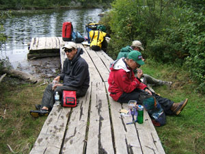 We decided to sit there and eat lunch before starting the portage. While we ate, we noticed a large logjam off to the right. In the continuing breeze, we could imagine the logs being driven to that spot by the wind, but most likely they had merely been pulled there by the current of the Little Madawaska River as it tried to flow into Hogan Lake.
After lunch, while the rest of the crew was starting the portage, I lingered behind to move gear off the dock and up into a more protected section of the trail. Then I noticed that a side trail led over to an old roadbed which, evidently, was still being maintained by someone at least as it connected with the portage trail heading east. Back toward the northwest, the roadbed was completely overgrown. On the return trip of my first pass, I decided to take the maintained part of the road instead of the portage trail and therefore missed the rest of the crew as they headed out on their second pass of the portage. (When the crew didnt see me coming or going, they wondered if I had managed to get lost!) The roadbed proved to be much easier to walk than the portage trail more level, less slippery, fewer rocks so I decided to complete my share of the portage using the roadbed.
Although the portage trail supposedly took us to Hogan Lake, it actually left us on a narrow channel among tall reeds and marsh grass. Larry and Rob loaded their canoe perpendicular to shore, then tried to launch from that position, but struggled to swing the bow out away from the shore. 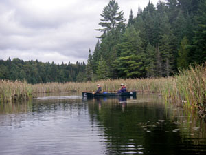 Jim and I found some logs extending out into a boggy area on the side, so we loaded and launched the canoe from there as we tried to balance on the logs.
At this point, the sun came through the clouds just briefly, giving us hope again that the weather would at last clear up. We meandered through the narrow marsh channel among the reeds and lily pads until eventually emerging into the main body of Hogan Lake. There we found the paddling tough. We were headed toward the northeast, but the wind was blowing strongly from the southwest, causing big waves to batter the gunnels of the canoes.
Our initial plan was to seek a campsite well up into Hogan Lake, but the campsite we had targeted appeared to have a red boat nearby suggesting that someone had already claimed the site. It was difficult to be certain, given the distance, but we did not want to paddle all the way there only to find no available campsite.
Somewhat discouraged, we decided to investigate a campsite on the peninsula of a large island near the east shore of the lake. The wind practically drove us onto the shore, and the following waves threatened to swamp us. Larry dropped off Rob to explore the site, and Rob quickly pronounced it suitable, but he suggested wed have better access on the lee (north) side of the peninsula. Pounding waves made progress over to that side really tough, but the improved landing turned out to be well worth the effort. So ended our easiest day of tripping, with the luxury of arriving at our campsite mid-afternoon instead of late in the day. We would not have that luxury again!
After landing, Rob and I did some more exploring (especially looking for the latrine), while Larry announced that this was a very nice campsite, with fairly level tent sites and pretty good protection from the wind because of a hump in the peninsula.
Since there were no obvious signs of rain, Larry and I decided our first order of business would be to put up clotheslines for drying our soaked stuff. After hanging up and spreading out gear all over the site, we finally erected our tent.
The weather continued overcast and windy, but dry for the time being. Rob and Jim decided to go out fishing in the canoe while we had this reprieve from rain, and we all looked forward to the possibility, however slim, that we might dine on fresh fish this evening. But after a half hour without even a nibble, they returned in discouragement. 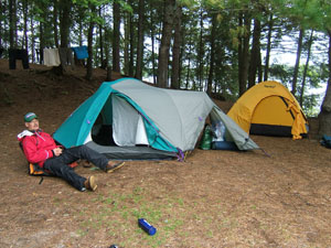 As it turned out, this would be the only time they would go fishing during the entire trip a real disappointment after paying so much for the licenses!
At one point during Happy Hour, Rob developed a case of hiccups, but he managed to get rid of them using a weird remedy: he held his breathe while massaging his earlobes. (Even weirder was his insistence that this earth-shaking event be recorded in the journal. But then, Happy Hour often spawns such weirdness, especially in Rob!)
Larry tried to pump water, but his new MSR filter didnt seem to be working acting as if it were already clogged after almost no use. He ended up having to use Jims filter even though it was exactly the same brand!
Squirrels in the nearby trees started making a big racket as we built and lighted the campfire. The site had plenty of firewood; though still damp from the previous days rain, it quickly dried out in the heat of the fire. The wind kept changing direction so that shifting smoke made various positions around the fire untenable, but we still appreciated the fire. We ate at a reasonable hour for a change, around 7:00 PM. Jim and Rob had Fettuccini Alfredo with Chicken, while Larry and I had Lasagna. Unfortunately, our time around the fire was cut short, as it began to rain sporadically around 9:00. In addition, everyone was weary and looking forward to a good night's sleep on level ground.
Overnight, the wind gradually died down, but at about 5AM, it gained new life and shifted from the southwest to the northeast.
Day 5 Thursday, 16 September
Another early departure; another wrong turn; rain, rain, rain; very difficult and long portage to Manta Lake; damp lunch; portages to Newt Lake and then Sunfish Lake; paddling through a marsh in the rain; lost and struggling in wind and cold rain on Catfish Lake; another camp setup shivering in the rain; cold food in the tents and no fire.
When we arose at around 7:00, the weather was cloudy and misty with sporadic brief showers. Evidently there would be no break in the dismal conditions today.
After the usual breakfasts, everyone pumped water, then set to work packing up. We broke camp at around 9:30 the earliest yet because we expected this to be our hardest day, with three long, demanding portages.
Upon launch, we paddled at an angle into stiffening wind and substantial waves attacking from the north across Hogan Lake. 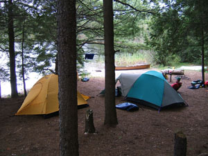 Then we headed due east into a large bay where we expected to find our next portage on the left shore. As we paddled, we thought we heard some shouting off to the north, but we couldnt see who was shouting or hear what he was trying to say over the noise of the wind and waves. Unfortunately, this bay turned out to be a dead end. After Larry took our bearings, we headed back out into the main lake and around a broad peninsula. An older couple, who were apparently camping at the end of the peninsula, stood along the shore waving at us. Evidently it was his voice we had heard earlier telling us we were going the wrong way!
We then continued northeast across Hogans Lake into a broad inlet where we were now certain wed find the portage. Skies were threatening rain again, but so far, so good.
Portage #13: Hogan Lake to Manta Lake (1945 meters)
It began raining in earnest as we unloaded to begin the portage, and it continued to rain throughout the day with growing intensity. This portage turned out to be the toughest of the trip! The trail was steep and rocky near both ends, and there were only two canoe rests: at 650m and 1150m. Most of the trail seemed to go endlessly upward. I started using my knit work gloves to hold the canoe rails while portaging. The rubber grips on these gloves, and the warmth they provided to my hands, and especially my fingers, proved so effective at holding and stabilizing the canoe that I managed to portage the entire distance without stopping although the last 600m were murder on my neck and shoulders!
We completed the portage at about half past noon, then paused for snacks at the end of the trail. Showers continued as we snacked, although the surrounding trees protected us from the direct onslaught. While we ate in damp discomfort, we noticed that the end of this trail featured another awesome display of mushrooms in various shapes, sizes, and colors. Although reluctant to depart this mushroom wonderland, we needed to keep moving, so we cinched up our rain gear and headed through Manta Lake, a small, narrow lake about four times as long as it was wide.
Portage #14: Manta Lake to Newt Lake (750 meters)
Newt Lake was even smaller than Manta more like a pond. The rain steadily increased as we portaged and then as we paddled the short distance to the next portage.
Portage #15: Newt Lake to Sunfish Lake (1105 meters)
In many respects, this portage was even tougher than Portage #13. The steep uphill and downhill segments were studded with many angular rocks that were especially slippery in the rain. The wind continued to pick up, while the rain seemed to wax and wane, although this apparent variability may have been more a matter of uneven forest cover along the trail than of actual rain intensity. In any event, in varying degrees, water was beginning to penetrate our rain gear. This depended in part on the type of rain gear each of us wore, but was also a byproduct of our exertions on the portage trails overheating coupled with occasional exposure to the elements as we sought to cool off by unzipping jackets or removing hoods.
On this dreary day, at least, Sunfish Lake had a forlorn appearance. From the shore, it was difficult to discern where our route lay through the sheets of rain and the seemingly impenetrable marsh lying to the south and southwest. After a brief paddle into the lake, we entered a narrow winding channel through the extensive marsh. Evidently Sunfish was mostly eutrophic, and much of the channel was weedy, like a thick vegetable soup, which made for slow progress. We hoped the marsh grass would provide some shelter from the wind, but no such luck. Rain continued more-or-less steadily.
After about an hour of meandering through the marsh, we reached the end of Sunfish Lake and entered Catfish Lake, closing the loop that we had set out on back on Tuesday.
The wind and rain were now blowing from the north, straight into our faces, and we had to paddle furiously to keep warm. The unremitting dampness crept through all our defenses, and gradually everyone became soaked to the skin.
Our objective was to reach the northern section of Catfish Lake by late afternoon, but weather conditions made that doubtful. After paddling into the wind and rain for a couple of hours, we were so cold, wet, and exhausted that we were ready to make camp despite the logic that it was better to paddle in the rain than to set up camp in the rain.
Larry was unsure of our location. Struggling through the wind and rain, trying to avoid broaching to the crosswinds that threatened to swamp the canoe, he had less opportunity than normal to consult the map, so he had stopped being able to match the topographical features of the lake against his map. In addition, visibility was very limited, and once it became clear that our goal was to find shelter as soon as possible, navigation was a low priority.
At one point, we decided that Jim and I should paddle up an inlet to see if it led to the main body of the lake. (Catfish is shaped roughly like a lower case y with numerous islands and inlets everywhere. We still thought we were weaving among islands in the tail, and we were trying to find our way into the v a broader, more open section in the middle that we thought of as the main body of the lake.) 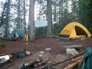 Instead of finding a more open expanse, we found a campsite which, upon cursory investigation, looked very appealing especially considering the weather conditions. We signaled Larry and Rob to join us. Once they reached the campsite, we unanimously decided to set up camp.
Everyone was wet and shivering even Larry, who was wearing supposedly rainproof gear. We all desperately needed to get into warm dry clothing as soon as possible. But the first order of business was to set up a tarp so the tents could be erected under protection from the rain. Larry and I helped Rob and Jim set up their tent first; then we tackled ours. As they had two days earlier, my fingers felt unresponsive, and I had great difficulty grasping anything or performing any task (like tying knots) that required fine motor skills. But then, everyone had some degree of difficulty with these tasks due to shaky hands and numbing finger tips.
Once we had the tents in place and were able to climb into them, we quickly changed to warm, dry clothing, then lingered in the tents trying to decide what to do next. We were all so worn out, yet so glad to be out of the cold rain, we just wanted to relax in the tents. Rob even decided to take a nap.
Eventually we had to decide what to do about dinner. Even though hot food would be welcome, the rain continued, and we were reluctant to exit the tents just to struggle with heating water for the meals. After a brief raised-voices discussion across the tents, we finally decided just to stay put and eat lunch foods (Clif bars etc.) for dinner. Even Rob was willing to skip Happy Hour just to stay within the warm, dry comfort of the tent.
After we ate, the rain began to taper off. But everyone was too cold and tired to leave the tents, so we all went on to sleep. Even though everything was damp inside the tents, we managed to sleep pretty well presumably from sheer exhaustion.
We gloomily expected to have to break camp in the rain next morning, but the rain finally stopped. At around midnight the wind changed direction so that it was coming more from the south, and it actually grew stronger at times overnight (accompanied as usual by a burst of loon calls). At one point overnight, Larry had to exit the tent, and when he returned, he remarked that the gibbous moon was visible through the clouds just enough to be a promising sign, although at this point we had pretty much given up on the weather.
Day 6 Friday, 17 September
Foggy morning; lost and wandering on Catfish Lake; we see a moose; returning over four portages, including the longest on the Petawawa River; repeat camp near the falls; difficult fire making and a battery explosion.
Arising at around 7AM, we found the conditions foggy, but without wind or rain. 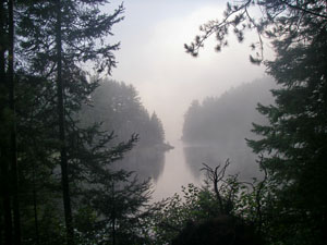 We hung up some items in meager hope that they might dry out a bit, but the surroundings were still too wet for that.
Most of us ate our usual breakfasts, but Rob was so hungry from skipping dinner that he prepared and ate the Chicken a la King that had been on the menu the previous night. What we took to be an odd breakfast choice turned out to be a sign that Rob had not brought enough food for the trip. He had, in fact, been suffering both hunger pangs and energy dissipation during the trip so far.
At one point we heard chopping noises and voices through the fog to the west presumably other campers but we could not see the campsite they had taken or determine where it was.
When we broke camp at around 10, we were amazed to find sunny and calm conditions for a change!
Larry was still uncertain where we were. Assuming we had camped on one of the islands in the southern archipelago of Catfish Lake, we set out again to look for a channel that would lead to the main body of the lake. First we went north, then east encountering evident dead ends in both cases then backtracked past the campsite to the more open area where we had struggled against the wind and rain the previous afternoon. Once in the more open waters, we headed northwest into a large bay that looked as if it might be the main body of the lake.
On the way, we spotted a moose browsing in the water along the east shore, and we paused to take photos. The moose seemed not the least bit alarmed at our presence, but eventually waded casually back to shore, then disappeared into the woods.
In our continuing efforts to figure out where to go, we separated a couple of times to check for passages in different directions. Encountering dead ends at every turn, we were beginning to develop a kind of Twilight Zone feeling of apprehension.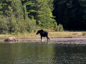 In frustration, Larry passed the map around for second, third, and fourth opinions, but none of us could identify our position relative to the topography on the map.
Finally Larry was able to match some landmarks to his map and realized we were actually in the northwest reach of Catfish Lake approaching Luckless and Lynx Lakes i.e. the wrong direction. Perhaps because we had paddled so furiously to keep warm the previous afternoon, we had made it much farther north than we thought, and as a result, we should have been looking for the portage out of Catfish Lake, not the main body of the lake. (As Larry later noted, it is very hard to go from point A to point B if you don't know where point A is.) After spending the whole morning meandering about in confusion, we tried to console ourselves with our moose sighting the only such encounter of the trip and one that we would have missed if we had not been lost. As a result, the whole affair came to be known as the Wild Moose Chase!
Heading back to the southeast, we paddled north past our campsite yet again into the same stretch we had probed earlier in the morning, but continued beyond one of the points where we had turned around before. Finally at around noon we reached the sought-after portage. We had actually camped less than two miles from it!
By this time, some clouds had started to appear, but the weather was still pleasantly sunny and dry, with only a light breeze.
Portage #16: Catfish Lake to Narrowbag Lake (80 meters)
This portage was the same as portage #5 and took us past the same rapids as on Monday.
Portage #17: Narrowbag Lake to Petawawa River (170 meters)
This portage was the same as portage #4 and took us around an unseen waterfall and rapids to the east. However, we were so absorbed in discussion about the navigational tribulations of the morning that we failed to see the portage sign on the left and went to the end of Narrowbag Lake before realizing our mistake. As we backtracked about a half mile, we started to wonder if this might be Wild Moose Chase Redux!
Once again, we noted that the portage trail crossed an old logging road flanked by timbers engraved with the words Caution: Road Crossing. Oddly, we were inclined to look both ways as we crossed, even knowing there was no possibility of traffic. Such is the power of signs!
Portage #18: Petawawa River (2345 meters)
After a brief paddle, we arrived again at our longest portage, which took us around Stacks Rapids the same as portage #3, but now in the reverse direction. Everyone was tired and sore by the end of this extensive portage, but we were in good spirits because the nice weather seemed to be gaining traction.
Portage #19: Petawawa River (255 meters)
This portage (the same as portage #2) took us to the left around the falls-like rapids where we had camped Sunday night. Although we were somewhat reluctant to repeat a campsite preferring variety to familiarity we realized that if we pushed on, we would end up camping on Cedar Lake, right across from the trappings of civilization. Since we were tired after the long portage anyway, we decided to make camp early and, by the way, take advantage once again of the pleasant white noise of the nearby rapids. The big disadvantage of this site, of course, was the lack of level tent sites, and this time around, their serviceability was further reduced by the dampness left over from so many days of rain.
The air was dry enough, though, so as soon as we had the tents in place, we set about stringing up drying lines and hung up all our wet apparel, sleeping bags, etc. We also spent a while filtering water, but Larry was still having trouble with his MSR pump and once again used Jims instead.
Because the nearby wood was still so wet, we found it hard to start a campfire. After a couple of failed attempts with flames springing up briefly, but then petering out Jim and Larry had to drag some fallen trees up to the fire ring and saw or break them up. To get the fire going in the first place, I had used the trash we had accumulated for a couple of days, but unbeknownst to me, Rob had thrown some used batteries into the trash. After the fire was going, Rob confessed to the deed, but by then it was too late to fish the batteries out. One battery exploded while I was tending the fire. The explosion was loud and startling, but caused no real damage other than precipitating an argument over who was responsible for this atrocity a dispute no doubt fueled by the spirits of Happy Hour! Rob called upon the nearest judicial authority (Judge Walter), but the ruling was somewhat indeterminate and, at any rate, subject to appeal pending further facts in evidence.
Eventually the campfire had enough embers to boil water for dinner, but by the time we actually ate, darkness had fallen. Our final trail dinners featured Cashew Curry Chicken for Larry and me and Chili Mac for Rob and Jim.
After expending so much effort on the campfire, we were motivated to hang around it as long as possible. But fatigue, shortage of dry wood, and a rapid drop in temperature forced us to retire relatively early. With only a half day remaining in our trip, we had no concern about bear depredations, so instead of trying to hang the food pack, we simply moved it away from the tents.
Once again, the restful white noise of the rapids helped us to fall asleep quickly. However, at around 1:30 in the morning, as if on cue, Larry and I both had to exit the tent at the same time. At that point, the temperature might well have dropped into the 30s, so we frantically hurried to complete our business. To anyone observing in better light, the whole spectacle might have resembled a Chinese fire drill!
Not long afterward, the modest northerly breeze we had enjoyed for most of the previous day changed directions and began to blow from the southwest, promising to mitigate the cold by morning. At some point before dawn, the breeze died down completely.
Day 7 Saturday, 18 September
Early rise; completion of the last two portages; high winds and waves on Cedar Lake; packing up at the outfitters; mishap by other boaters; vehicle acceleration problems; more rain; stop at North Bay Honda; stay in Barrie; the meal of our fantasies.
Knowing we had a long day of driving ahead of us, we were all up around 6:30 the earliest rise of the trip. Conditions were calm, and although a heavy mist hung over the river, the skies were clear above.
After indulging perhaps a bit too enthusiastically in the previous nights Happy Hour, I did not feel well and decided to skip breakfast. The rest of the crew, however, enjoyed well enough their last breakfast in camp.
As breakfast proceeded, the skies began to cloud up, and a southwesterly breeze reappeared, growing steadily and gradually shifting more to the west. 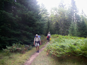 Fearing that we might encounter rain again before we could finish the trip, we hurriedly gathered drying items from the lines, packed up our gear, and by 9:30 were ready to complete the portage past the rapids whose sound we had so enjoyed overnight.
Launching at the other end of the portage trail, we continued up the Petawawa and soon reached our final portage of the trip.
Portage #20: Petawawa River to Cedar Lake (715 meters)
This portage on the right around rapids was, of course, the same as our first portage, but in reverse. For some reason, the trail seemed longer this time through perhaps because (unlike the first time) we had already done one portage this morning, not to mentioned many portages over many days. At the end of the trail, we paused on the shore of Cedar Lake for snacks and photos.
As we set out across Cedar Lake in a northerly direction, the wind continued to build and was now blowing stiffly from west producing huge waves that crashed against the gunnels of the canoes, threatening to swamp us. We had to struggle to keep the canoes angled and stable enough to prevent capsize. Our progress was slow, exhausting, and at times almost frightening but also perversely exciting and exhilarating!
As we approached the north shore and the welcoming buildings of Brent, we noticed a small motorboat heading out from the outfitters dock toward the west. 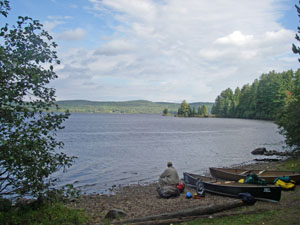 We were surprised that anyone would go fishing in such blustery weather and assumed the destination fishing spot must be in a more sheltered area, perhaps Marshy Bay.
We reached the outfitters post at around 11AM and began the onerous process of unloading the gear from the canoes and hauling it over to the Honda for repacking. Then we went into the outfitters store to settle up our accounts. We noticed a couple of guys sitting by the wall who were evidently soaking wet. Later we learned that they had capsized while trying to paddle across Cedar Lake shortly before us, and that was the reason the motorboat had sped across the lake earlier: to rescue them.
The long trip home was an ordeal of its own. As we returned up the 25-mile gravel road, it did not take long to figure out that the engine warning light was not attributable to a loose gas cap. Whenever the accelerator was pressed more than moderately, the engine would miss, forcing the driver to ease up on the pedal and, of course, slow down. Nevertheless, we continued driving northward on the road, stopping briefly at the park office before reaching Highway 17 and turning west.
To add to our troubles, it began to rain and would continue to rain most of the day. Our biggest concern, other than a complete breakdown, was the loss of momentum when we had to go up the long hills on the highway. At times, we slowed as much as 40 mph before cresting those hills, but generally we managed to limp along till be reached a Honda dealer in North Bay. 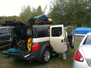 Of course, the maintenance department was closed on Saturday afternoon, but the sales people were very friendly and helpful, and one of them was able to run a computer test on the car despite standing in the pouring rain. The tentative diagnosis was that it was a computer problem: The computer thought the car had no oil pressure and would shut the motor down whenever it thought the acceleration threatened motor damage. So the good news was that we probably were not in danger of breakdown and we would not damage the car by driving it, but the bad news was that we would have to drive it under these conditions all the way home until a qualified Honda mechanic could replace the computer chip.
So, we continued south through the rain at a slower pace than we would have preferred and made it as far as Barrie, Ontario, where we found rooms at a Comfort Inn. Rob and Larry had been fantasizing during the canoe trip about the ideal steak dinner they would like to have once they got off the water, but they had no real expectation of realizing that dream. Nevertheless, they asked the young woman at the motel registration desk for a restaurant recommendation, and she replied without hesitation: the Keg Steakhouse. After what we had endured over the last week, the Keg turned out to be a dream come true for all of us. Rob and Larry had exactly the meal of their fantasies, including a wonderful cabernet sauvignon to complement it; and Jim and I, who arent normally inclined to eat beef, became steak enthusiasts for at least one night!
Day 8 Sunday, 19 September
Continuation of trip home; stop in Howell; clearing skies.
The next day, we continued our long trip home, still hampered by the inability to accelerate. As each of us took a turn at the wheel, we went from backseat critic to sheepish bumbler as we tried to master the technique for coaxing the car along. We were delayed for a considerable time at the border due to the usual security checks, but finally made it to Howell in time to enjoy another sumptuous lunch prepared by Emily. Once everyone was fed, and I had removed my gear from the car, the three Ohioans said their goodbyes and headed south for the final leg of their return trip. And only now, after days of struggling against inclement or uncertain weather, did we finally get to enjoy the clearing skies that had been forecast over a week earlier!
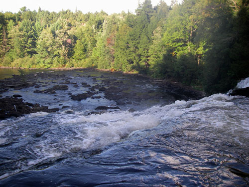
J. Brown & L. Walter
December 26, 2010