Upper Missinaibi River
Ontario, Canada
July 9 - 19, 1994
This memorable canoe trip took us down one of Canada's most famous Arctic watershed rivers. It was the longest of our trips (10 days), and this is consequently the longest of our journals. The frequent rapids were consistently challenging, the waterfalls breathtaking, the portages arduous, the insects intense, and the weather severe. Every day brought new challenges and dramatic scenery. Highlights included pictographs on Missinaibi Lake, multiple moose encounters; running huge haystacks at Wavy Rapids, boulder dodging at Albany Rapids, and thunderstorms and hail at Glassy Falls. Both canoes capsized during the trip, and slips and falls on the treacherous trails were common. This was without question one of the best trips ever. This journal was written by Jim Brown. - L. Walter
Friday, July 8
Trip preparations; waiting for the Ohio contingent.
Rush hour traffic was more frustrating than usual because of lingering rain from an earlier storm. I thought about all the things I still needed to do to get ready for the trip things that I wouldn't have time to do because of the Little League Baseball game I had to coach when I got home. What a relief to come home to a phone message that the game had been canceled! Apparently the diamonds were too wet. That left me free to finish packing and clean up the canoe.
Larry had called the previous weekend to say that he and Rob planned to leave the Cincinnati area around 6:00 PM; so I expected them around 10:30 PM and had so informed Doug. Doug in fact arrived shortly after 10:30. We threw my gear into the back of his Aerostar and hoisted my Penobscot onto his custom designed wooden rack. Doug had brought copies of an article from Backpacker Magazine about a canoe trip down the Lower Missinaibi the very trip we wanted to do next so we talked about that and about the impending trip for a while, expecting Larry and Rob to show up at any minute.
When they had not arrived by 11:00, we decided to get some rest. Emily and Chris were away in Virginia Beach; so Chris's bed was available for Doug down in our "finished" basement. I reclined on the sofa in the family room so that I could look for Larry's Toyota van when it pulled up in the driveway.
At around midnight, a vehicle pulled up in the driveway. I turned on the light in the basement and shouted to Doug, "They're here!" But it turned out to be one of Peter's friends, who had come over to announce that he had just sold his car stereo to some guy in the parking lot at the local Burger King.
Saturday, 9 July (Day One)
Packing and departure; the trip north; breakfast in Sault Ste-Marie; arrival in Missanabie; unloading and repacking; meeting with Ownie; paddling Dog Lake; marshy trailhead; portage across the height of land; camp on Crooked Lake.
About a half hour later, though, Larry and Rob finally arrived. They had been delayed almost two hours by a huge traffic jam just outside Toledo. After quick greetings, we plunged into the traditional confusion of trying to get things transferred, organized, stowed, mounted, and secured to/in/on the Aerostar all in a stupor of excited fatigue. An hour later we were finally ready for departure. I took the wheel as the initial driver. Doug was in the front passenger seat.
To signal our departure, my cat Whiskey suddenly let out a bloodcurdling yowl. After a moment of awe and amazement, we realized that Doug had accidentally slammed his door on the cat's tail. Peter's girlfriend, Jennifer, quickly rescued the cat, and we at last backed out of the driveway. But Rob immediately adopted the cat's yowl as the "musical theme" of our trip.
We set out to look for a gas station to "top off" the fuel in the Aerostar. We had to go to Hartland to find an open one. Once fueled, we headed north and didn't stop again until intense drowsiness forced me to pull into a rest area near West Branch. Doug took the wheel and drove to Mackinaw City, where we stopped for fuel. Larry then took over and drove to Sault Ste Marie. Through this entire period each member of the crew tried to sleep at one time or another, with varying degrees of success. After several such trips, though, we were all resigned to the mind-numbing fatigue we'd inevitably face on the first part of our expedition.
After crossing the bridge into Sault Ste Marie, Ontario, we began searching for a place to have breakfast. Rob suggested we go to Smiley's a touristy place we had visited on our Wakami trip four years earlier. But we decided to stop at a restaurant we hadn't tried before, a place that specialized in waffles and pancakes. Rob decided on a robust eggs/bacon/pancake meal. Larry and Doug had malted pancakes, and I had a malted waffle. We asked what "malted" meant in this context, but no one at the restaurant seemed to know. We amused ourselves with the notion that the secret ingredient might be malt liquor!
After breakfast we headed to the Trading Post where we had purchased our camping and fishing licenses two years earlier for the Mississagi trip. We were shocked to discover that the Crown Land camping fee had more than doubled from $4.50 per day to $10.00 per day! We were all dismayed and rather incensed at this increase because it was obviously aimed at Americans, even though American parks have no such fees that apply to Canadians or anyone else. None of us had really budgeted for this unexpected situation. Doug and I were thrown into a "cash flow crisis" until we discovered that we could pay the fee with a credit card.
From the Trading Post Larry drove us up Highway 17 along the Lake Superior coast to the town of Wawa, which we had last visited six years ago enroute to our White River expedition. In Wawa we searched for a place for Larry and Rob to buy sandwiches for consumption at dinner that night at our first camp. After wandering around the "downtown" in a dank, breezy drizzle, we located a restaurant that agreed to supply a couple of take out sandwiches.
Back in the Aerostar, Rob took over the driving to complete the trip to the village of Missanabie. Drizzle was still falling when we pulled up to the launch site on Dog Lake behind the historic Missanabie Hotel (historic because it had at one time been the home of the manager of the Hudson Bay Company). The time was only 12:30 PM. Larry had asked the outfitter, Owen Korpela, to meet us there at 2:00; so we had well over an hour to kill.
We removed the canoes, unloaded the Aerostar, and began a determined, if somewhat disorganized, preparation for launching the canoes in some cases reorganizing, reconsolidating, and repacking our gear. Considering the cool, drizzly conditions, we were surprised to find a robust population of black flies. We had hoped that scheduling the trip in July, after the normal black fly season of June, would drastically reduce our chances of encountering the little buggers. But apparently we had miscalculated or perhaps this was a vintage year for flies! I was still dressed in shorts and a thin polo shirt; so I took the opportunity to change into something warmer and more water and bug proof. Rob offered some pretext for going up to the hotel, then slipped away to have a beer.
While waiting for Owen, we noticed two guys paddle by out in the lake in a yellow canoe with a bright orange tarp amidships. This incident immediately revived a concern we had had ever since we had begun planning this trip: that the Missinaibi was such a popular canoe route, and July such a popular month, that we would encounter a lot of competition for campsites along the route. We could just imagine these two guys in the yellow canoe grabbing our first intended campsite, wherever that might be, sending us paddling desperately on through the gathering dusk in search of a suitable alternative.
As promised, the shuttle arrived at around 2:00 PM, although it turned out to be Owen's father, "Ownie." Ownie had brought along a copy of the Missinaibi map/brochure (put out by the Ministry of Natural Resources) that he had specially annotated with campsite and fishing information. He now proceeded to walk through his notes and, in the process, helped Larry determine where our first campsite should be.
At around 2:30 we were finally ready to depart. We were all tired, but eager to get out on the water. Doug took the bow of the Penobscot, and I the stern. Rob took the bow of the Tripper, and Larry the stern. We would maintain this configuration for practically the entire trip. (The only regular exception: Doug and I would alternate bow and stern from time to time in the Penobscot.) We launched the canoes, and the Missanabie Hotel quickly disappeared from view as we headed southeast along the shore of Dog Lake. We passed by numerous cabins and a few motorboats, then rounded a point and headed northeast, passing under a train trestle. Just behind us a southbound train crossed the trestle. Later we passed under the Highway 651 bridge where, according to Ownie, many people start the Missinaibi trip in order to avoid some of the lake paddling. Then we headed southwest into a more open area of the lake. Gradually the signs of human habitation diminished, and the lake took on more the look of "wilderness".
The dank weather continued, and the drizzle was occasionally interrupted by a more persistent rain. But we were in good spirits and, in fact, found the cool wet conditions to be very conducive to paddling. As we meandered through the various straights and widenings of Dog Lake, heading in a generally easterly direction, we paused several times to snack on trail mix. On the water we encountered a few loons; along the shores we saw an occasional beaver lodge; in the sky we spotted a hawk or two.
At around 5:00 we entered an increasingly narrow stretch of the lake and eventually came to a dead end. Here we were supposed to portage, but there were no clear signs of the portage trail. Doug and I ventured over to the right bank and searched up a narrow creek until our progress was blocked by the underbrush. Meanwhile, Larry and Rob headed over toward the left bank and found the trail in a marshy area just beyond a mudflat. The mud was so mucky and the footing so poor that we were forced to pole, shove, and heave the canoes through the mud well up into the trail before we could unload the gear. Previous voyageurs had made an effort to improve the footing at this landing by placing logs on the trail. But the logs themselves were wet, muddy, and very slippery. As troublesome as this trailhead proved to be, we were pleased to see it decorated with a virtual garden of blueflag.
This 510 meter portage trail took us from the Michipicoten River watershed to the Moose River watershed, thereby crossing the "height of land" between the Great Lakes and Arctic watersheds. From here on we would be heading toward James Bay! The trail supposedly passed on the left around a flume, but we never did see the flume. We did see the skeletal remains of an old wooden cabin at the end of the trail. We also got our first real taste of the abundant mosquito population and were chagrined at already having to resort to our headnets. I was pleased, however, to find that the portage yoke pad I had installed on the Penobscot was more comfortable than expected. At home I had found it actually painful, but on the trail we quickly learned exactly where to position it on the shoulders for maximum relief.
We now launched on Crooked Lake, where we hoped to find the campsite that Ownie had recommended. At this point, we had already canoed more than eight miles, and the weariness and lack of sleep were beginning to take their toll. The campsite we were looking for was supposed to be on an island near a point on the right shore where the Missinaibi River flowed into Crooked Lake. When we reached the site, however, we were dismayed to find - exactly as feared that it was already occupied by the two guys with the yellow canoe we had seen earlier. We continued about a half mile beyond the site and spotted another potential campsite on the right shore. While Larry and Rob investigated this site, Doug and I paddled another quarter mile down to an island that looked as if it might have a decent campsite. The island turned out to be a dud, but Larry and Rob were already motioning us back: They had decided the site they were checking was acceptable.
The site was pretty well protected by trees and shrubs (hence was quite buggy) and had three somewhat unlevel spaces for the tents, with a "kitchen" area and fire ring closer to the water. The only real escape from the mosquitoes was provided by a jumble of rocks at water's edge, where a modest breeze could be felt. Even so, the site was a welcome relief for four wet, weary, hungry travelers.
The time was now about 6:30 PM. The weather remained overcast and misty. We quickly set up the tents, then turned our attention to food. Larry and Rob ate their sandwiches while Doug used his stove to heat water for our meals. Doug had a Backpacker's Pantry Enchilada dish and some soup. I had Shrimp Newburg and Garden Vegie Mix.
After dinner, we made some half hearted efforts to "secure" the camp, then retired to the tents, completely exhausted. The time was about 8:30. We all slept pretty well that night, despite some leakage in the tents from the continuing drizzle.
Sunday. July 10 (Day Two)
Late departure; the debut of Bugman; paddling down Crooked Lake; remains of a water tower; lunch on the water; passed by the speeding yellow canoe; encounter with the father/son team; portage to Missinaibi Lake; pictographs at Fairy Point; camp at Whitefish Falls.
In the early morning hours the rain picked up several times, but by daybreak the sky had begun to clear. A heavy mist lingered over the surface of the lake.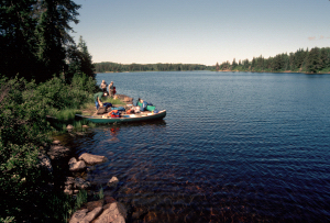 Doug arose before 7:00 to heat breakfast water on his stove and to put up lines for drying the gear. With the surroundings so wet, there was little hope of starting a campfire.
The rest of the crew arose around 8:00. By then the sun was beaming brightly and a pleasant breeze had sprung up. We set about the concurrent tasks of preparing breakfast and hanging or spreading our gear out all over the place to dry. Partly because of the drying efforts and partly because we had not yet established an efficient routine, we didn't break camp until almost 11:00. In fact, Larry and Rob launched the Tripper before Doug and I were finished packing. While they waited for us, Larry filtered water out in the lake.
Doug and I soon joined them with the Penobscot. As we headed northeast away from the campsite, we noted that the two guys in the yellow canoe were still in camp. Now that we were "ahead" of them, we hoped we'd have our pick of the best campsites that afternoon.
The weather was now delightful: sunny, breezy, with temperature near 70 degrees. The bright sun spurred Doug to don a pair of "sun goggles" that made him look like a creature from outer space. Rob had a field day with this piece of equipment. He dubbed Doug "Bugman" and suggested that Doug wouldn't need insect repellent for the rest of the trip because the bugs would think he was one of their own.
As we proceeded up the lake, we paused a couple times to snack on trail mix, power bars, etc. 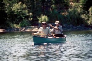 The lake widened and narrowed in spots, but for the most part it resembled a river more than a lake, especially with the trailing breeze creating a "current" at the surface. (In a sense, Crooked Lake is just a section of the Missinaibi River.)
At around 12:30 we spotted the remains of an old rusty water tower at the back of a clearing on the left shore. At the risk of arousing the local bug population, we decided to investigate. Larry, his competitive instincts aroused by the challenge of the yellow canoe, remained in the stern of the Tripper, waiting impatiently as we explored the water tower and casting apprehensive glances back toward the westward channel. The structure turned out to be so decrepit that it was hard to imagine that it had ever held water. The interior was full of junk and garbage. A partly overgrown access "road" snaked off into the woods behind the tower. Out of curiosity we followed it a short way, then returned to the canoes.
Just downstream from the site of the water tower were the remains of an old bridge. Presumably this bridge had once allowed access to the water tower from the opposite shore. As we canoed past the fossil bridge pilings, we spotted the guys in the yellow canoe less than a half mile behind us. So much for our "lead." It was already 1:30 PM. We had to decide whether to try to "outrun" them or stop for lunch. Hearty voyageurs that we were, we stopped for lunch.
A wise decision, as it turned out, because these guys were paddling with military speed and precision. As we drifted along enjoying our lunch and watching Rob fish, they passed us with a full head of steam, pausing only to shout "Hello". At 60 strokes per minute, they paddled with crisp efficiency and even switched sides to a sharp "Hut!" without losing a stroke. They looked as if they were in a race, but we couldn't figure out whom they were competing against (obviously we wouldn't be able to provide much competition!) or what they were competing for (the next good campsite?).
Given their speed, we figured we wouldn't see them again for the rest of the day. So it was surprising and rather curious that we caught up with them about an hour later at the portage from Crooked Lake into Missinaibi Lake. We talked with them enough to learn that they were father and son. Originally from London, Ontario, the father now lived near the southern reach of Georgian Bay and the son now lived in Victoria. They had started their trip on Lake Superior, paddled upstream on the Michipicoten River to the chain of lakes including Dog Lake, and were now in the fifth day of their trip enroute to Mattice, our own destination. They were carrying with them a couple of bicycle wheels, which aroused our curiosity. It turned out that they had used the wheels to turn their canoe into a "cart" for negotiating some long stretches of road that served as portage trails for the earlier stages of their trip. Their fiberglass canoe was longer and heavier than the Tripper or the Penobscot, but the son now hoisted it up on his shoulders like a toy and forged down the trail with nary a misstep. We later learned some things that helped explain this hardiness, not to mention the canoeing efficiency: the son was a member of the Canadian Forces Pararescue Team and a champion marathon canoe racer!
Even so, from a "competitive" point of view, portaging seemed to be their "Achilles heel". Either they had too much gear, or they didn't have the right bags to carry it, or perhaps the father (who appeared to be about 65, but in excellent shape) was unable to handle the portaging as well as the paddling. For whatever reason, they were slow getting through this 360 meter portage. We managed to get our canoes and gear to the other end of the trail before them and were well out into Missinaibi Lake before they completed their portage.
Once on the lake, though, they charged past us again as we paused for a snack. We watched them head for Red Granite Point on the right shore of the lake, then veer off toward Fairy Point on the opposite shore. They were almost out of sight by the time we resumed paddling. At this point the breeze had grown to a robust wind, creating substantial waves in the lake. Fortunately the wind was from the southwest. We needed to head southeast to Fairy Point, round the point, then head northeast; so the wind would be more or less behind us most of the way.
At Fairy Point we paused to look for Indian pictographs on the rocky bluffs at water's edge. At first we saw only orange lichens on the bleached rocks.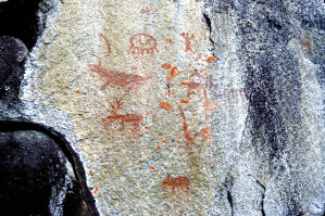 But eventually our eyes adjusted to faint red markings that suggested moose, bear, birds, and even men. Supposedly these pictographs were 500 years old! At first, we marveled that these images could have withstood the elements for so long. But then we began to feel concern that they might not, after all, last much longer, exposed as they were to the more modern effects of acid rain.
Pictographs were also supposed to be on another rocky bluff across from Reva Island, about a half mile south of Fairy Point. We debated whether to make this mile round trip detour, half of which would involve paddling into a stiffening wind. Curiosity won out over Rob's Reaganesce protestations ("You've seen one pictograph, you've seen them all.") However, these pictographs were less distinct and harder to find than the ones at Fairy Point, and we had to be satisfied with just a few faint markings scarcely worthy of a photograph not to mention having to put up with a Mosser diatribe about the "wasted" time and energy.
Once we resumed our northeasterly course, we made excellent progress because the wind was directly behind us.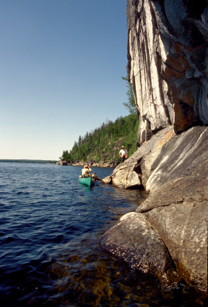 It was now about 5:30. We began to look for a campsite that had been recommended by Ownie. It was supposed to be on the northwest shore across the lake from the mouth of the Little Missinaibi River. But as we approached the Little Missinaibi, we could just barely make out that the campsite was already taken, presumably by our friends in the yellow canoe. Larry and Rob decided to investigate a potential campsite on a breezy, rocky bluff on the bay that formed the mouth of the Little Missinaibi. There they found more pictographs on a rock outcropping just below the bluff. Across the bay was a low sandy beach that would have made an ideal campsite, but it was guarded by a "No Camping" sign.
While they explored the potential campsite, Doug and I paddled farther into the bay to look at Whitefish Falls, a two meter waterfall where the river actually dropped into the lake. Then we headed for what appeared to be a portage trail sign past the waterfall. In the process, we encountered an unexpected oddity: a picnic table sitting in a small sandy clearing at water's edge. We decided to investigate this discovery after we had confirmed the portage trail.
It turned out that the picnic table fronted a small but serviceable campsite nestled just a few feet back in the woods. This site would certainly be an acceptable alternative to the site Larry and Rob were checking out. But we were curious about a trail that led away from the site back toward the falls.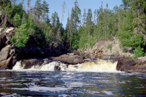 We began to follow the trail and, in the process, spotted Larry and Rob paddling in from the bluff. We shouted for them to take a look at the campsite, then continued along the trail. As suspected, the trail led to the falls. From there we bushwhacked up to a narrow chute just above the falls where the river dropped about four feet. The river narrowed so much at this point that we could almost leap to the other side!
We were soon joined by Larry and Rob. Larry announced that the campsite on the bluff had turned out to be unacceptable: poor access to the water and not enough level space for the tents. But the campsite with the picnic table had all the features we needed. In fact, as Rob pointed out, it even had a feature we had overlooked: a pit toilet!
We returned to the site and began to set up camp. There wasn't much level space for the tents; so we had to put them pretty close to each other. In fact, we had to position my Eureka Overlander so that it blocked the trail to the latrine, much to Rob's consternation. There wasn't much room for drying lines either, and the ones we put up were mostly in the shadows. The whole campsite was rather close and breezeless, and the black flies and mosquitoes began to ring the dinner bell. It was about time for our dinner, too; so Rob started a fire and began heating water.
Meanwhile, I decided to try out the latrine. I was surprised to find it in excellent shape. Like the picnic table, it showed little signs of use. In fact, when I lifted the lid, I found the mouth of the toilet full of cobwebs. Apparently this campsite was not well known- perhaps because it was not marked on the brochures.
We ate dinner at around 7:30.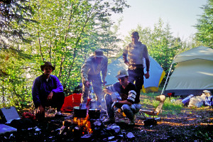 Larry and Rob had Wild Tyme Turkey, peas, and cheesecake. Doug had Richmore's Sierra Chicken. I had Cheese Nut Casserole, which turned out to be the least palatable of the AlpenAire freeze dried meals I had brought on the trip.
After dinner, Rob and I went out in the Tripper so that I could filter water and he could fish near the falls. There we encountered an elderly gentleman and his grandson fishing from a motorboat. We talked with them briefly and found out they were from Grand Rapids! They informed us they had just caught a half dozen walleye in a mere twenty minutes using jigs. This news really excited Rob, who decided to come back in the morning with his jigs. Now it was getting dark, and the mosquitoes were growing more and more voracious. In fact, we were surprised that the old guy and the boy had been fishing in shorts.
After we returned to camp, an effort was launched to hoist our food bags up out of the reach of potential bear visitors Then Larry and Rob settled down around the campfire to relax and enjoy their Dewar's Scotch and Bailey's Irish Cream. Doug and I couldn't relax because of the increasingly belligerent mosquitoes so we retired to our tent. Before long the mosquitoes forced Larry and Rob to retire as well.
That night most of us slept pretty well, the "white noise" of the falls pleasantly muffled by the surrounding trees and bushes. Our tent site was somewhat sloped, though, and all night we had to fight a tendency to slide toward the entrance of the tent.
Monday, July 11 (Day Three)
Cool morning; fishing at the falls; Jim suffers a migraine and nausea; strong winds on Missinaibi Lake; lunch on the boulders; the Narrows; moose encounter; Missinaibi River; encounter with Missouri canoeists; Quittagene Rapids; four moose; Cedar Rapids; tiered campsite; rigging tarps in the rain; campfire talk.
During the night the temperature dropped from a somewhat humid 65 degrees at bedtime to a low of about 42 degrees just before dawn. In my tent we had left our "windows" open, and by 5:00AM my sinuses had begun to ache from the cold air. By the time we were ready to get up (around 6:30) 1 had both headache and nausea- the classic signs of a migraine.
Rob still wanted to go fishing back near the falls; so I went out with him in the Tripper. We dressed warmly because the temperature was still just 50 degrees even after the sun had come up. We positioned the canoe on the edge of the turbulence just below the falls, and Rob began to work his jig while I attempted to update the log. We were there for only ten minutes when I suddenly got the heaves. Fortunately I could just lean over the edge of the canoe and barf directly into the water. Rob immediately halted his fishing, and as soon as my stomach would allow it, we paddled back to camp. I felt too nauseated to eat anything; so while the rest of the crew ate breakfast, I lay down in the tent.
My illness posed somewhat of a problem for the expedition. I had developed migraine headaches on the White River and Mississagi, but on those trips we had had a "spare" crewmember (Rob) to take over the paddling while I rested amidships. Now Rob was a fulltime paddler, and we had no spare. Unless I was prepared to paddle ill, we really had only two options: (1) Stay in this mosquito infested campsite till I felt better (i.e. for most of the day) or (2) Try to continue with just one paddler in the Penobscot. Option (2) was rapidly fading, though, because a vigorous wind was steadily building from the southwest, making it increasingly unlikely that one person would be able to control the canoe.
After lying down for about 45 minutes, I decided I didn't want to stay in this campsite any longer. I would just have to paddle through the migraine. I joined the preparations for departure, and we broke camp just after 10:00. When we were ready to launch, I took the stern of the Penobscot so that if I felt dizzy (as I usually do with a migraine), I'd have most of the canoe in front of me for support (in the bow it would be a lot easier to keel over into the water).
We started up Lake Missinaibi with a strong, steady southeasterly wind behind us. The wind made for excellent progress, but also made it difficult for us to keep the canoes straight. We spent much of the time "ruddering" to keep the canoes from swinging around into a broach position. Whenever we paused for a break, we had to hold the canoes together to create a stabilizing "pontoon" effect.
At one point, as we passed to the east of Mary Island, we spotted a campsite along the shore of the island and thought we saw the familiar yellow canoe with the bright orange tarp. It now occurred to us that the campsite we had lost across the lake from the Little Missinaibi had been taken by the fishermen we had met at the falls. The guys in the yellow canoe must have continued down this far to make their campsite. We were now "ahead" of them again.
The southwesterly wind continued to build, and the sky began to cloud up. We decided to stop for lunch in the lee of a large island in the middle of the lake. As we passed around a spit on the west side of the island, we noticed two guys (presumably fishermen) standing near a campsite on the island. We tried to ignore them and found a relatively calm spot on the far side of the island where we couldn't see them or their campsite. 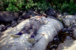 The shore here was just a jumble of large, angular boulders, but we were able to dock the canoes and find suitable perches for a relaxing lunch. I was still bothered by headache and nausea; so I declined to eat anything. Instead, I located a boulder with a relatively flat surface and just lay there trying to nap. The conditions were really quite pleasant. The temperature was about 70 degrees. The wind here was reduced to a bug chasing breeze, and whenever the sun began to get uncomfortably warm, a cloud would pass over to cool us off. I could easily have stayed here the rest of the afternoon.
When we resumed canoeing, we encountered the strongest winds yet whipping up huge waves with whitecaps. At times we felt like Hawaiians surfing in outrigger canoes! We were glad the wind was more or less behind us rather than in our faces.
Eventually we approached a spot called "The Narrows", where the lake became very shallow (maybe two feet) and harbored an extensive garden of bright green reeds. From a distance the reeds created the illusion of dry land, making it look as if we had come to the end of the lake. This shallow reed farm forced us to paddle along the western shoreline for about a half mile.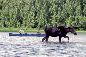 Just past The Narrows we encountered a cow moose in the middle of the lake casually munching on water weeds, her head just above the water. We stopped paddling, but the wind and waves blew us past the moose; so we paddled back "upstream" on either side of the moose to take photographs. The moose did not seem the least bit alarmed that we had "flanked" her, but eventually she decided to move to a more "defensible" position.
We continued across a more open stretch of the lake to a reedy point on the east shore where there were supposed to be the remains of an old Hudson Bay post called the "Missinaibi House". Doug and I got out of the canoe to investigate, but all we saw were a couple of brownish signs that said "Area Closed to Public Use." We got back into the canoe and struggled around the point, largely against the wind and waves, to catch up to Larry and Rob on the other side. After a brief discussion as to whether we should go back and investigate further, we decided to continue on.
Before long the lake narrowed into river width. We were now officially on the Missinaibi River. Larch trees appeared on the shore for the first time, to join the white birch, alder, black spruce, and white cedar. The wind died down a bit, and the clouds that had built up so quickly around lunchtime now pretty much disappeared. We started to feel pretty warm in the canoes.
As we approached a right bend in the river, we spotted a bull moose over on the left bank. The moose moved warily back into the woods as we fumbled with our cameras trying to take photos. Suddenly we realized we were in the accelerating current leading into Quittagene Rapids. Doug and I quickly back ferried over to the head of a portage trail on the right bank. Larry and Rob headed more directly to the right bank and just missed getting sucked into the rapids. To get back to the portage trail, Larry had to line the Tripper back upstream.
Once we had the canoes safely out of the current, we went down the portage trail to scout the rapids. At the end of the trail we encountered a party of four canoeists. Three of them were from Missouri and looked to be in their mid fifties. One was from Alberta and looked to be younger, maybe in his late thirties. They told us the rapids were easily runnable, but we decided to investigate further. Back up the trail we found a side trail that took us over to the rapids. From there we could see that the rapids were OK except for some pillows and a rooster tail over on the left side. Back at the canoes, we tied everything down, donned our PFD's, and then launched. Our strategy was to start out on the left side, where the water was a bit deeper, then maneuver over to the right side to avoid the pillows and rooster tale. The strategy worked fine for both canoes, although we both took in water from large standing waves near the end of the run. This run our first of the trip was lots of fun and whet our appetite for more.
At the bottom of the rapids we looked up to find four moose lining the river, two bulls and a cow on the left bank, one cow on the right.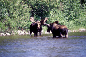 We approached as close as we could to get photos, but the three moose on the left bank moved back up into the woods. The cow on the right bank moved downstream just ahead of us for a while, but eventually she also lumbered up into the woods and disappeared.
Continuing downstream, we encountered Cedar Rapids, which we ran without scouting. About a half mile beyond these rapids, we noticed a campsite on the left, but the site did not look especially appealing, and in any case it was still a bit early to make camp. (Later we would learn that the guys in the yellow canoe had taken this site.) The sky began to cloud up again rather quickly, and many of the clouds looked dark and rain-laden. By now the effects of the migraine were wearing off, and I began to feel much better.
At about 5:00 PM we passed the confluence of the Missinaibi with the Hay River, which entered from the right. Rob thought there would be good fishing here, but we couldn't stop because we had begun to look for a campsite that had been recommended by Ownie. On the map this site appeared to be the last decent campsite until Allen Island, which was more than a day's canoeing away, and we wanted to make sure we got it before the Missouri party or the guys in the yellow canoe caught up with us.
As we moved into the "homestretch" leading to this site, we spotted a promising looking campsite high up on the right bank. We considered stopping to investigate, but since we had not yet reached the point that Ownie had indicated on the map, we decided to pass this site and return to it only if there was a problem with the recommended site. This decision was a calculated risk, though, because our "competitors" might reach this site before we had a chance to get back to it.
We continued downstream for almost another mile, but there were no signs of the recommended site. We finally gave up and decided that the site Ownie had in mind must be the one we had passed and that he must have just misidentified its location. We turned around and headed back upstream at a breakneck pace, hoping against hope that the campsite was not already claimed. Fortunately we found the campsite empty. It was ours for the taking.
The campsite turned out to be fairly attractive, with one tier for the kitchen/fire area, a higher tier for a couple of tents, and a still higher tier for another tent. Unlike our previous two campsites, this one was rather open which gave us some hope that the bugs wouldn't be so bad. But it was also less accessible from the river: We had to paddle fifty meters upstream of the site to find a suitable landing, and even there we could find no level area onto which we could pull the canoes. After unloading the canoes, in fact, we just left them floating in the water tethered to white cedars along the bank.
As we hauled our gear up to the campsite, we heard thunder, which signaled that we'd better set up camp quickly. We erected the tents right away.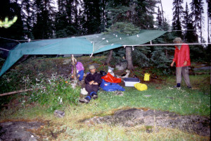 Then Rob and I gathered firewood while Larry and Doug tried to set up a tarp over the kitchen/fire area. When the storm hit, Larry and Doug were still struggling with a jury-rigged maze of ropes in efforts to secure a combination of Larry's polyethylene tarp and Doug's nylon tarp. Rob and I noticed a two meter log sitting by the fire ring and suggested they use it as a kind of "pillar" to prop up the whole mess. Somehow that, plus a couple additional ropes, did the trick.
When we took shelter under the tarp, though, we discovered that the mosquitoes had exactly the same idea. once we got the fire going, the smoke seemed to chase some of them away, but they continued to be a real nuisance the rest of the evening.
For dinner I had Almond Chicken and peas. I had planned to have Apple Almond Crisp for dessert, but the main course filled me up. In fact, I ate only one of my ten desserts during the entire trip. The AlpenAire main courses and vegetable dishes were all designed for two people, and Larry and Rob were sensibly splitting theirs. (This evening, for example, they shared a meal of Beef Rotini, mixed vegetables, and Apple Almond Crisp laced with Bailey's Irish Cream.) Doug, on the other hand, had divided his AlpenAire meals in advance and had repackaged them as one man portions in burnable plastic bags an equally sensible but more time consuming approach that had the advantage of leaving no trash to pack out. I ended up having to pack out both unopened desserts and used foil pouches.
After dinner, we sat around the campfire talking for a while as rain showers sporadically rattled the tarp. We were trying to decide what goal to set for our next campsite, which would determine, of course, how far we would paddle the next day. The only campsite marked on the map within a day's paddle appeared to be at Barrel Rapids, which was less than seven miles away. After that we would have to paddle another sixteen miles to get to a decent campsite at Allen Island. Twenty three miles would be within our range if the route were strictly flatwater. But we expected to encounter at least half a dozen rapids along the way, most of which would require time to scout and/or portage. And if we failed to make it as far as Allen Island before nightfall, we'd have to resort to "bushwhacking" a campsite, probably in some horribly bug infested area of Peterbell Marsh. Barrel Rapids was billed as a good place to fish; so we considered paddling a short day, setting up camp early, and letting Rob spend most of the afternoon fishing. The problem was that we were now "competing" against two other confirmed parties traveling on more or less the same schedule as our own. Our "competitors" would surely pass us if we stopped at Barrel Rapids and then go on to take the campsite at Allen Island, which was billed as the best site on the entire Missinaibi route. We wanted at least a good shot at that campsite.
We decided to sleep on the issue and put off any decision till we actually reached Barrel Rapids the next day. After all, the campsite at Barrel Rapids might be so bad that we wouldn't want to stay there anyway.
We were all ready to turn in at around 11:00 PM. We were pretty tired, and rather than hoist the food bags out of possible bear reach, we just moved them away from camp down by the canoes. The rain had stopped, but the tents were wet, especially the Overlander. My Slumberjack pillow had fallen off my Therm a Rest mattress into a puddle of water on the tent floor and was now too soaked to use. I tried to jury rig a pillow with a pile of dirty clothing, then fell into an uneasy slumber, fully expecting to have a neckache in the morning.
Tuesday, July 12 (Day Four)
Rainy night; Rob's diaper rash; visit by the Missouri Bunch; toilet innovation; drying equipment and breaking camp; running Long Rapids; running class III rapids; Sun Rapids; running Barrel Rapids to avoid trail quagmire; paddling in the rain; separation anxiety; alternative undesirable campsites; exploring Peterbell; sleepless night amid the trains.
Another thunderstorm rumbled through the area around 4:00AM, pelting the tents with rain. But when we awoke at 6:30, the sky was completely clear, with a hearty breeze and temperature near 60 degrees. We remained in the tents for a while listening to some birds raucously chasing each other through the air out over the river. Then Doug left to chop some firewood and start a breakfast fire while I reclined on the Thermorest catching up the log.
Larry, Rob, and I all exited the tents around 8:30 to begin hanging and spreading our stuff to dry. Rob complained of a case of "diaper rash" caused by the poor breathability of the bright lavender nylon pants he had worn since the start of the trip. He asked if anyone had zinc oxide ointment, but no one had brought any on the trip. It appeared the only solution was to go around bare assed for a couple days, which would of course offend our delicate sensibilities. He finally had to resort to Benadryl cream.
Before we had a chance to eat breakfast, we received a surprise visit from the Missouri Bunch, who were apparently early risers (unlike our friends in the yellow canoe). They had spent the night back at Quittagene Rapids, where we had first encountered them. They stayed to chat for almost half an hour. Doug in particular quizzed the "odd man out" from Alberta, who had canoed quite a few Canadian Rivers including the Missinaibi two previous times and pronounced the rivers in the Chapleau region better than any out west.
After the Missouri Bunch had departed, we exchanged concerns again about the competition for the campsite at Allen Island. The Missouri guys were now ahead of us; the guys in the yellow canoe were probably not far behind; and we were nowhere near being ready to break camp. The prospects did not look good, and all this competition was beginning to adversely affect our "wilderness experience".
One "wilderness experience" I had been putting off was a first date with the new "port o potty" I had brought along. This cross between a toilet seat and a folding TV table promised to relieve us of the need to find logs in the woods suitable for sitting. Now I resolved to test the equipment. I carried it to a private but relatively breezy spot along the river upstream of the camp, where I quickly dug an appropriate hole, slapped bug dope on all the vulnerable body parts, completed the assignment in short order (including the requisite paper work), and back filled the hole to preserve the aesthetics of the scene. The beauty of it was that I could just leave the port o potty right there for subsequent users. In fact, Rob tried it next, and then Larry. All they had to do was move it over slightly and dig a different hole.
As the campsite warmed with the morning sun, we accelerated our drying operations, tilting the tents on their sides, for example, to increase the air flow to the saturated tent floors. With the drying operation and the unexpected camp guests slowing us down, some of us didn't get around to breakfast until about 10:30. We were still eating when Doug attempted to remove his nylon tarp so that he could pack it. The sudden reduction in tension caused our "pillar" to fall over, flipping the grill, spilling the hot water, and putting out the fire. Larry ended up boiling some more water on his stove.
We continued to break camp in this somewhat sporadic manner and didn't complete the job until almost 11:30 which suggested a default decision on the previous night's discussion: We'd have to take a short day of paddling now; so we might as well plan to camp at Barrel Rapids and give up the idea of "winning the race" to Allen Island.
When we finally launched the canoes, the sky was sunny and mottled with white, fluffy clouds. A brisk wind from the southwest promised easy canoeing. Doug and I switched in the Penobscot: Now that I no longer felt dizzy, I took the bow. Rob and Larry remained in their usual positions in the Tripper: Rob in bow, Larry in stern.
We soon came to Long Rapids, which supposedly had a 200 meter portage on the left. Larry scouted the initial rapids by simply standing up in the Tripper; then we ran them easily. After this run, Doug and I sling-shotted into the lead and quickly encountered a succession of four more rapids presumably accounting for the name "long rapids".  The first three rapids we ran without scouting and with little concern except for some large standing waves that put water in the bottom of the canoe. But the fourth rapids looked somewhat troublesome, passing to the left of a small island and extending around a left bend where we couldn't really see what we might run into. We decided to pull up next to the right bank just beyond the island so that we could examine the lower rapids. But as we approached the end of the island, we realized that the current passing around the other side of the island would make it impossible for us to "stop" along the right bank. We quickly executed a right eddy turn into the calm water just below the island, then turned around to survey the lower rapids. Meanwhile Rob and Larry went right on past us without a pause and ran the remaining rapids. We followed them with no further ado.
Next we came to some more formidable rapids. These rapids had no name, but the map indicated two 100 meter portage trails on the left around their upper portion. As we approached, we spotted the Missouri Bunch in process of lining the rapids along the right bank; so we decided we'd better scout them carefully. From the end of the portage trail we could see why the Missouri Bunch had not tried to run the rapids. There were two major pillows on the left side and three souseholes: one small one on the right, one big one in the center, and another small one just past the pillows. This was Class III whitewater and the biggest challenge we had encountered. After much strategizing and discussion, we decided to portage the gear and run the rapids in empty canoes.
Doug and I went first. We started from the center, pulled to the left between the two pillows, then pulled to the right between the center and left souseholes. We took some water, but otherwise completed the run without incident. Then we turned into an eddy near the left bank and paddled back upstream to get into position to take photos of Larry and Rob as they came through. Larry and Rob followed roughly the same path through the rapids and also completed the run unscathed.
After reloading the canoes, we paddled out to the middle of the river to enjoy snacks away from the mosquitoes. Under way again, we soon approached Sun Rapids. Ironically, the sun had now disappeared behind dark, heavy clouds! The rapids themselves were another series of three or four rapids, some of which featured large standing waves again, but all of which we ran easily.
Just beyond Sun Rapids we ran into a brief rainshower that soaked everything. Then we came upon Barrel Rapids, our "default" objective for the day. What a disappointment! The landing for the portage trail was a quagmire. The trail rose from the river at such a steep angle, and the rain had rendered it so muddy, that it was virtually unusable. It was hard enough to climb even without packs. With packs it would have been a slippery nightmare, and portaging the canoes would have been utterly impossible. We struggled up the trail in hopes that scouting would reveal that the rapids were runnable.
Not far from the trail head we found a small, muddy, miserable campsite. The brochure said there was a "really nice" campsite just below the rapids; so we continued to the end of the portage trail in search of this campsite. No sign of it. We even extended the search down an overgrown trail farther downstream, but soon gave up as our way was blocked by fallen trees and dense stands of fir. Fortunately the rapids looked runnable; so we returned to the canoes and shot the rapids fully loaded.
The time was approaching 5:00 PM. Now that we had given up on our default campsite, we had no idea where we would camp. According to the map, the next established campsite was at Swamp Rapids, at least thirteen miles away. That campsite sounded dismal, but even if it were worth pursuing, we wouldn't reach it until after 9:00 PM. Our only real recourse was to start looking for spots along the river where we might be able to "bushwhack" a camp.
As if to drive home this somber point, the weather became increasingly unfriendly. The sky clouded over completely and became a grey, sullen overcast. The wind shifted around into our faces and became dank and uncomfortable. Another rainshower hit, and the cooling temperatures forced everyone into raingear- everyone except me. My raingear was in my riverpack, and my riverpack was in the Tripper. By the time I could get to it, I would be soaked anyway; so I didn't even try. Instead, I took "shelter" under my PFD. For a short while the PFD shed the rain like an umbrella, but as the rain picked up, I became wetter and wetter. Finally I just donned the PFD as an insulating vest. Even though I was soaked to the skin, the PFD kept me warm as long as I was paddling; so Doug and I settled into a strong, steady paddling rhythm that soon put us well ahead of Larry and Rob.
Soon we came upon the Missouri Bunch, who had done exactly what we expected to have to do. They had bushwhacked a camp in a modest clearing on the left bank of the river. They admitted it was horribly mosquito infested, but as far as they were concerned, they had no alternative.
We resumed our northerly course downstream into the wind and driving rain. Doug and I pulled farther and farther ahead of Larry and Rob until we could no longer see them behind us. Then we rounded a bend to find a train trestle crossing the river just ahead. We were now just outside Peterbell, which was really just a railroad stop for canoeists, hunters, and fishermen. On the left bank of the river we noticed the remains of unidentifiable structures that had once been made of brick, cinder block, and corrugated metal. Jutting out from the bank was a dilapidated floating dock, and not far from it was an old aluminum boat. We decided to investigate.
The bank was extremely muddy. From there a short trail led up to an open, breezy area covered with wildflowers (clover, wild daisies, etc.). Near the center of this open area was a small pile of trash and rusted metal pieces. A winding, overgrown road led away from the site toward the railroad tracks, which were a couple hundred meters away. Along the way was the rusted out shell of a jeep or humvee. The whole area was breezy enough that we were not bothered at all by mosquitoes. But I had to move around constantly to stay warm.
We returned to the river to wait for Larry and Rob. No sign of them. Unbeknownst to us, they had stopped to investigate another site back upstream. Larry had blown his whistle to signal their intentions, but the wind and rain had kept us from hearing the signal. After waiting for ten minutes with increasing concern, Doug and I began to speculate that Larry and Rob had passed us while we were exploring this site. We returned to the canoe and continued downstream in hope of seeing them just ahead. We canoed under the trestle and then past the pilings of a previous trestle to a point where we could see well down a fairly straight section of the river. Still no sign of them.
Then we headed back upstream toward the last place we had seen them. After paddling for about fifteen minutes, we were about ready to give up. Confused and alarmed, we were prepared to turn around again and paddle downstream the rest of the afternoon until we caught up with them. Then we spotted the Tripper over on the left bank (our right, since we were heading upstream). A great weight of anxiety was suddenly lifted from our shoulders! Larry appeared and motioned us over, then led us up into a site that was pretty well overgrown with small fir trees but had just enough space for a couple tents. He and Rob had already started to set up my tent on his tarp. (Larry's own tent was in his riverpack, which was in our canoe.) The site was damp, of course, and pretty well sheltered from the breeze; so conditions were ideal for the mosquitoes. They enveloped us in a large, menacing cloud. My immediate inclination was to get away from this place as quickly as possible, but Rob invited us on a brief tour down a trail lined with wild strawberries. We had a brief discussion about the relative merits of the two campsites, but having seen both sites, Doug and I lobbied strongly for the more open, breezy site downstream.
Rob and Larry were not happy about the prospect of halting their camp setup and relocating; but our glowing reports of the other site aroused their curiosity enough that they were willing to go take a look.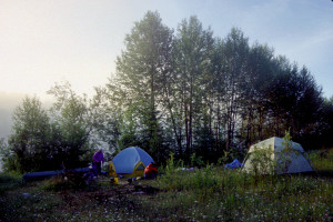 Our reports were colored, of course, by a strong desire to escape the mosquitoes. Larry and Rob were skeptical that any campsite would be free of mosquitoes. in these soggy conditions; so they were more interested in the aesthetics of the site. It was not surprising, then, that when they finally saw our site, they found it disappointing. Even so, we were all relieved to be reunited and making camp at last. We quickly set up the tents, then went about our separate affairs., Rob, for example, went for a relaxing pre dinner coctail.
Rob and I then decided to go exploring. We followed the overgrown road/trail over to the railroad tracks, then walked along the tracks over to a line of railcars parked on a side track. Most of these cars appeared to be designed for transporting some kind of liquid, but one was humming with a generator that produced electricity for lights (and presumably other equipment) on the cars, and a couple cars appeared to be designed for sleeping. We were tempted to knock on a door to find out if anyone was on board, but decided not to take the chance of waking someone who might work a night shift and sleep during the day. Besides, the last thing we needed was to be accused of trespassing by some irate rail worker.
Continuing down the tracks, we spotted a cabin just to the north with a sign over the front door: "Camp Cost a Lot". The cabin looked well used, but it was in pretty good repair, and the surrounding lot had obviously been mowed. It was also surrounded by a number of small sheds and outbuildings, one of which held a large supply of firewood. No access roads were visible; evidently this was some kind of hunter's cabin accessible only by rail.
Meanwhile, back at camp Larry was filtering water and Doug was exploring the remains of a sawmill back in the woods behind the camp. Doug then decided to hike over to the railway and walk out on the trestle to take some photos. He saw Rob and me over by the railcars in the opposite direction, but we were a good distance away at that point, and in the dim light he assumed we were rail workers and didn't respond when we waved.
When Rob and I returned to camp, Rob started a fire while I tried to get my portable stove going. After some struggle, I managed to boil enough water for my own dinner, which consisted of Shrimp Alfredo (my best entree of the trip), Mixed Vegetables, and Apple Almond Crisp (the one and only time during the trip that I made and ate a dessert). Everyone else's dinner used water boiled on the grate over the campfire. Larry and Rob had Cajun Rice with Chicken and Peaches 'n' Cream pie. Doug had Richmore's Turkey Supreme.
During dinner we resumed our discussion of the competition for campsites. We had not seen the guys in the yellow canoe at all that day, and the Missouri party was now camped 2 3 miles upstream from us. As far as we knew, we were ahead of everyone. If we broke camp really early the next morning and paddled hard through the flatwaters of Peterbell Marsh, we had a good chance of beating everyone to the Allen Island campsite. We decided to get up at 6:00AM the next morning, skimp on the breakfast preparations, forget about drying anything, and try to get on the river by 8:00AM.
That meant we needed to turn in early. But then, it was really too wet to do anything around the campsite anyway, and as the winds died down, the mosquitoes began to move in for their main course. Once again we skimped on the anti bear arrangements, simply hauling the food packs down to waterside away from the tents. Inside the Overlander I strung up a criss cross clothesline to air out my wet clothing. (An outdoor clothesline would have been pointless, as the rain continued sporadically well into the evening.)
Getting a good night's sleep was going to be a problem, though. As remote as this site was from population centers, it was like Grand Central Station for railroad traffic. A train rumbled across the trestle about every half hour, it seemed, and every train insisted on blowing its whistle as if there were anyone around who needed to be warned that the train was coming. At one point probably around midnight a train stopped nearby, made sounds as if it were backing up and jockeying for position, then took off with a loud blast of the whistle. The whole show might as well have been staged for our benefit!
After this cacophonous night, Rob found occasion each day for the rest of the trip to remind us how much he had "enjoyed" the train traffic at the campsite WE had recommended.
Wednesday. July 13 (Day Five)
Early departure; Peterbell Marsh; Rob catches a walleye; Swamp Rapids; Deadwood Rapids; Allen Island portages; encounter with a black bear; failed search for the wonderful campsite; camp at Wavy Rapids; Rob and Larry fly through Wavy Rapids; Jim and Doug submerge; bath below the rapids; Bill and Will; walleye appetizer; Toronto canoeists join our camp; another submersion and rescue; dinner preparations and bear-proofing.
By 6:00AM the sky had completely cleared, and the temperature had dropped to around 45 degrees. But everything was still very wet.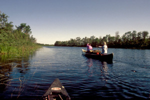 For breakfast we boiled only enough water (on Larry's stove) to make coffee and cocoa. Then we took down everything and packed it wet. The last items to get packed were the port o potty and shovel, which came into sudden demand just before our departure. We were on the river by about 8:15AM, more or less as planned. For a change, Larry and Doug took the Penobscot, and Rob and I took the Tripper.
As we approached the railroad trestle, we spotted the familiar yellow canoe up on the left bank directly under the trestle. Apparently our friends had spent the night nearby, but we couldn't see where they had pitched their tent. Now we were sure we were in the lead and that, for a while at least, we would have the best chance of laying claim to the coveted campsite at Allen Island. Just after we cleared the trestle, a train rumbled across it overhead, and the engineer leaned out the window of the locomotive to wave at us. We waved back and, in so doing, bid a fitting goodbye to this noisy place!
We proceeded into Peterbell Marsh at a good pace. The wind was in our faces, as it had been the previous afternoon, but it was now light and refreshing. The sky was bright and sunny. After several miles of reed and lily gardens and oxbow lakes, we paused for snacks. Rob decided to fish for a while. Almost right away he caught a walleye just under two pounds. He put it on the stringer, then handed me a rod with a jigging worm while he prepared another rod with his "Erie Dearie" lure. We fished for another twenty minutes but caught nothing.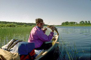 Meanwhile Larry filtered water while Doug stretched out and relaxed. Larry's water filtering reminded me that I was low on water. (I hadn't had a chance to filter water that morning or the previous afternoon.) Rob had packed his water bottle in a bag in the Penobscot; so he didn't have any water at all. We both ended up pretty thirsty by the end of the day.
After this break, we were a little concerned that we might have lost some of our lead over the competition. We resumed paddling at a vigorous pace, slowed only by the walleye dragging in the water at the end of the stringer. By 11:00 AM we had reached Swamp Rapids, which marked the northern terminus of Peterbell Marsh. A 200 meter portage trail on the right skirted two sets of rapids and supposedly passed by an old cabin. Only the cabin's foundation remained. After briefly scouting the rapids, we ran them both with little ado. Then we encountered a series of four unnamed rapids, which we ran without scouting. The third rapids featured a nasty pillow near the end. Larry and Doug went first, then signaled to us from below the rapids that we should go to the right. We were a little late interpreting the signal, but still managed to avoid the pillow, just skirting it on the right.
A mile farther downstream we encountered Deadwood Rapids, which was supposed to have a 135 meter portage on the right. Larry scouted the rapids standing up in the Penobscot, then pronounced then runnable. The run went without incident. We were having so much fun now running all these rapids that we almost forgot about the "race". We briefly discussed whether to continue on to Allen Island to make sure we would get there first. But we were all getting hungry; so we decided to stop for lunch.
For the entire morning we had been paddling more or less north. After Deadwood Rapids the river curved to the south. When we resumed paddling, it took only about a half hour to reach Allen Island. The island itself was almost a mile long and had rapids on either side at its farther (southern) end. The brochure said that we could take the river on either side of the island. If we took the right fork, we would encounter two portages around rapids: one 180 meters on the left, followed immediately by a 135 meter portage on the right. If we took the left fork, we would encounter one 310 meter portage on the right around some falls. From the information we had, we couldn't tell where exactly to look for the great campsite we had heard about. Larry's book on Ontario rivers recommended the left fork, but Ownie's notes suggested it was on the right fork. As navigator, Larry decided to take a chance on the right fork.
As we approached the first of the two portages, we noticed a large logjam that had apparently formed at the top of the rapids, obscuring them from view. On top of the logjam was a black bear, the first one we had ever seen on any of our trips. The bear stared at us for about thirty seconds, then lumbered off into the woods along the right bank. We didn't have time to pull out the cameras, and we never saw the bear again. Nevertheless, we vowed to hang the food packs high at our next campsite.
The portage trail was a real mess. The landing was difficult to approach and extremely muddy. To the left of the landing was a badly damaged and clearly abandoned fiberglass canoe. The trail itself was tortuous and full of roots, rocks, potholes, logs, and slippery, uneven spots. There was certainly no wonderful campsite here! At the end of the trail, we looked back upstream at the rapids from the other side of the logjam. We could see that they were too rocky for us to have run, even if the logjam hadn't been there. The rapids just downstream appeared to be a better prospect. They curved around to the right into some large standing waves, but the only real problem was a large pillow right in the center just above the standing waves. After launching the canoes, we passed through a center "V", then pulled to the right to avoid the pillow, then crashed through the standing waves, taking in plenty of water.
Below these rapids we rounded the southern tip of the island and noticed over on the left the rapids/falls that marked the end of the left fork. We could also see the end of a portage trail on a section of the island just below the rapids. We decided to check whether the sought after campsite was somewhere along that trail. Hiking up the trail, we encountered increasingly dense undergrowth, "low overheads", and multiple confusing trail offshoots all of which suggested that this trail was seldom used, least of all for portaging canoes. There was no sign of a campsite anywhere. We finally gave up and concluded (mistakenly, as we later learned) that the wonderful Allen Island Campsite was just a myth.
Not far downstream from Allen Island we came upon Wavy Rapids, which marked a sharp bend in the river back toward the north. Since we couldn't see very well what was around the bend, we decided to use the 180 meter portage trail on the right to scout the rapids. Near the end of the trail we found a beautiful campsite nestled among the trees, with a nice fire ring, plenty of tent space, easy access to water (including a potential bathing area), and lots of places to hang or spread things out to dry. The time was only about 3:00 PM, but the decision to make camp here was a no brainer!
The rapids themselves featured an abrupt drop off followed by almost a dozen huge haystacks and rooster tails. There was no way we would risk running these rapids with loaded canoes, but with empty canoes we could turn the run into a challenging game, and if we lost the game, the only penalty would be a good soaking. The river just below the rapids widened out into a calm bay; so if we capsized in the rapids, we'd have a fairly easy time recovering ourselves and the canoes; and then we could just dry ourselves in camp afterwards in the warm sunlight.
We proceeded to portage the gear, set up the tents, string up drying lines, hang some stuff on the lines, and spread other stuff out on the rocks in the sun.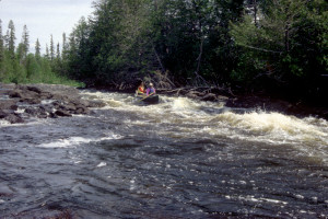 By about 4:00 we were ready to run the rapids. First, we reshuffled the lineups: Larry went back to the Tripper, and I went back to the Penobscot. As usual, Larry took the stern, Rob the bow. As Doug and I waited on the rocks with cameras poised to capture the run, Larry and Rob swiftly entered the "V", plunged over the initial dropoff, crashed through the first haystack, shot up in the air, slammed down on the second haystack, and continued through the remaining waves as if they were riding a bucking bronco. They even let out a rodeo yell befitting the experience.
After witnessing this spectacle, Doug and I could hardly wait to get back to the Penobscot for our run. We decided that I would take the bow and Doug the stern so that the canoe would be tilted back somewhat to reduce the amount of water it would take in hitting the waves. We were somewhat frustrated at the start because, in order to reduce the gear portaging distance, the Penobscot had been parked in a rock garden downstream from the point where we need to start our run. We had to paddle, poke, and pole our way through a rocky obstacle course to get far enough back upstream. Meanwhile Larry and Rob waited down on the rocks to get photographs of the run.
We started our run in pretty much the same fashion as Larry and Rob. After hurtling over the initial dropoff, though, we plowed right into the first haystack, taking in an enormous amount of water. As we plowed into the second haystack, we could feel the water in the canoe shifting to the left. The canoe began to list; the water inside the canoe joined the water outside it; and together they dragged the canoe beneath the remaining waves. Doug and I were both washed out of the canoe like a couple of ants.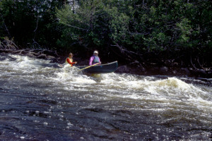 Doug held onto the gunwale on the upstream side of the canoe, and I swam away from the canoe to avoid getting hit by it. The rushing water felt wonderfully refreshing, but our immediate concerns were to make sure we hadn't lost any gear and to get the canoe over to shore. We managed to hold onto our paddles, and I was able to grab a few odds and ends floating in the water, but we were missing Doug's hat, my headnet, and one of my kneepads.
As Doug pushed the canoe over toward the right bank and I swam after them both, Larry made his way through the underbrush along the shore to throw us a line. Eventually we got the canoe close enough to shore for us to touch bottom. We inverted the canoe to let the water out and flipped it back over to refloat it. Then all three of us got into the canoe to go look for the missing items. We circled around the bay below the rapids in a counterclockwise direction, but we couldn't find anything. As we completed our circle and approached the current at the end of the rapids, Larry issued a warning from the middle of the canoe: "Be careful, the current may destabilize the canoe." Within seconds, the current caught the canoe and nearly flipped it. We took in some water, but managed to regain our equilibrium. Then we headed straight for camp.
After this adventure, we all decided to take a bath. Larry and Doug found a spot just off the "sandy" beach where the water was deep enough to bathe but not too rocky or mucky. While they bathed, Rob filleted the walleye, and I filtered water while crouching on a rock out near the rapids. (I had had only one cup of water all day and was very thirsty.) By the time I finished filtering, Rob was bathing, and Larry and Doug were dressing.
As I prepared to take my own bath, the guys with the yellow canoe showed up. They finally introduced themselves as Bill (the father) and Will (the son). They informed us that the Missouri party had made camp at Allen Island. Apparently the legendary wonderful campsite was on the left side of the island and well upstream from the portion of the portage trail we had investigated. We had completely missed the campsite because we had taken the right fork. Bill and Will now intended to do the portage, then paddle farther downstream until 7:00 PM. Because they seemed determined to keep going for another couple of hours, we didn't think of inviting them to join us in this nice campsite. But afterwards we felt bad that we hadn't at least extended the invitation.
I finished my bath, put on some clean dry "camp clothes" (i.e. clothes worn only around camp, never in the canoe, and never when it was raining), and then began hanging up more things to dry and/or air out while snacking on some smoked Edam and wheat thins left over from lunch. Meanwhile Rob began breading and pan frying the walleye, and Larry went out on the rocks next to the rapids to filter water and sip Dewar's. I joined Larry, and while we were talking, Doug brought to us the fruit of Rob's labors: freshly cooked walleye. It was fantastic the perfect appetizer! Soon afterwards we went back to the "kitchen" for "seconds".
At around 7:00 a party of four canoeists three men and a woman, all apparently in their late 20's or early 30's suddenly appeared on the trail passing through our camp. They began portaging their gear, but a couple of them stopped to chat. One of them, who introduced himself as Leo, mentioned that they were from Toronto. He and his friend, Jim, were accompanying a married couple, Mike and Kim, on a trip from Missinaibi Lake to Mattice. Mike and Kim had left two young children with her parents so they could make the trip. Since we still felt bad about not having invited Will and Bill to stay in the campsite, we extended the invitation to these canoeists. Kim seemed reluctant, but Leo readily accepted. Mike and Jim withheld their opinions until they could discuss the matter.
Meanwhile, Mike and Kim decided to run the rapids in their Pensobscot. We told them what had happened with my Penobscot and offered to wait for them just below the rapids in the Tripper just in case they suffered the same fate. They accepted, although they seemed pretty confident they would have no trouble with the run. During their run, in fact, they made it successfully through the first three haystacks and had just begun to raise their arms in triumph when their canoe listed to the left and sent them sprawling into the water. It seemed that the Penobscot just wasn't made for these rapids!
Larry and I quickly paddled over to them and tried to grab their bow painter, but Kim's foot was tangled in it. She had to cut the line with a specially serrated knife she was carrying. We tried dragging the water logged canoe over to the left bank while they held onto the gunnels, but we weren't able to make much progress. Then we decided to try a textbook "rescue" technique: pulling the overturned Penobscot up across the middle of the Tripper and perpendicular to it, thereby emptying out the water, then flipping the Penobscot over and sliding it back into the water upright. After a struggle getting the canoe up on the Tripper, we managed to pull off this feat. Mike was then able to climb into the canoe, but Kim had a harder time of it. Now that the canoe was no longer water logged, though, we were able to get it close enough to shore so that she could touch bottom, stand up, and climb in.
As we returned to camp, we noticed that Leo and Jim were taking a bath clear evidence that they had decided to stay.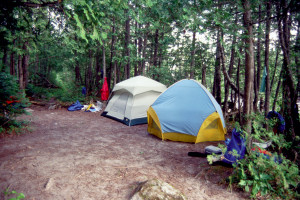 Once ashore, Larry turned his attention to dinner, and I went out on my favorite rock beside the rapids to work on the log. At one point Larry talked with Kim and Mike and found out that later in the trip they were planning to take the same "detour" we were considering: a one mile portage into Brunswick Lake.
Eventually (at about 8:30) Rob called for me to come eat. By this time, everyone else had already eaten, and the remaining hot water was boiling away. I used it for Wild Rice Pilaf with Almonds and a "side dish" of mixed vegetables. I also had some leftover mocha mousse, compliments of Larry and Rob. Their main course had been Beef Stroganoff. Doug had eaten Tuna and Noodles.
While we were eating, our "neighbors" decided they wanted to set up their tents where we had our drying lines. They said just to take our time, but they acted rather impatient; so we complied as quickly as we could. Having accepted our invitation to stay in this camp, they were beginning to act as if we were the intruders!
After dinner we spent quite a while trying to hoist the food packs high above the trail. After several broken limbs, we finally found an arrangement that worked and looked as if it would last the night. At this point it was getting pretty dark. I thought about going back out to the rocks to filter some water, but the mosquitoes were getting so bad that I decided just to wait until we were out on the river the next day. We all turned in around 10:30 PM, resolving again to get up at 6:00 the next morning for departure by 8:00.
The conditions should have made for great sleeping: the evening was cool and dry; the nearby rapids made a restful rushing sound; and I had had a chance to take a bath. But the struggle to hang up the food packs had made me all sweaty; the ground under our tent sloped toward the left of the door, causing me to slide over toward Doug every time I moved; and every hour or so a train went by, producing just enough raucous noise to break through the white noise of the rapids. (Apparently we had looped back toward the tracks that we thought we had left behind at Peterbell. Now they were only about a mile away!) I ended up sleeping rather fitfully.
Thursday, July 14 (Day Six)
Dew theories; portage around Greenhill Rapids; Rob flips for Hellpack; Bill and Will again; running many rapids; portage confusion; Calf Rapids; drifting lunch; portage around Split Rock Falls; portage around Thunder Falls; camp across from the falls; wine and dinner; good sleeping.
As planned, we awoke around 6:00AM. The weather was cool and clear, and there was no dew on the tent. Doug invoked the old saw that absence of dew indicates rain within 24 hours a rather discouraging notion because we had had rain every day of the trip so far. But I thought the evidence was inconclusive: In this case absence of dew might just mean the surrounding trees had prevented any dew from reaching the tent. Mist hovering above the surface of the river suggested that we would find dew on the canoes, which were out on the "beach" away from the trees. In fact, the canoes turned out to be wet with dew, and we hoped the converse old saw would hold true that presence of dew meant there would be no rain in the next 24 hours.
Because we wanted to get an early start again, we dispensed with a campfire and resorted to the stoves to heat water for breakfast. We tried to keep quiet to avoid waking up our neighbors, but their Jim emerged from his tent almost immediately. We talked with him for a while about various matters, including the startling increase in the daily camping fee. He expressed surprise and chagrin at the increase, but of course, as a resident of Ontario he did not have to pay the fee.
We broke camp at around 9:30. By this time, the rest of our neighbors had emerged. As we loaded the canoes, we remarked that we might see them again at some point farther downstream. We were just making casual, friendly conversation, but Kim replied rather bluntly, "We've appreciated your hospitality, but frankly I don't want to see you again." Apparently she and her party had expected a "complete wilderness experience", devoid of any people. Finding us at this campsite had been a real letdown for them. To avoid any more contact with people, they had decided to remain in camp for the day and even take a "day trip" back upstream to look at Allen Falls. Given Kim's decidedly unfriendly attitude, we were tempted not to inform them that they would likely encounter the Missouri Party, whom they had unknowingly avoided the previous day by taking the right fork around Allen Island.
After launching the canoes, we cruised downstream through calm water, keeping a lookout for the lost hat and kneepad. The water was so still it looked like glass. Larry decided to take several photographs of us in the Penobscot with our almost perfect mirror image below. But he had some trouble positioning the canoes to get the best angle for lighting.
The river flowed north for a couple of miles, then turned to the west. Soon we reached Greenhill Rapids, which was actually a series of five blind rapids. The portage trail on the left was a full kilometer in length and cut across a broad curve in the river to end at the mouth of the Greenhill River, which flowed into the Missinaibi from the southwest.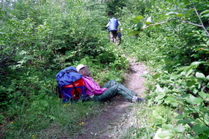 The trail departed so far from the river that there was no reasonable way to scout the rapids; so we resigned ourselves to the lengthy and arduous portage. A registration box at the head of the trail invited us to log in, but the registration book was full.
The portage trail featured a steep climb at the beginning, a steep decline at the end, and plenty of winding ups and downs in between. Rob decided to take the Hellpack challenge. As he started up the initial steep incline, he made the mistake of straightening up to peer over the top of the hill. This slight shift of balance was enough to flip him over backwards. For a while he lay on his back on top of Hellpack, struggling like a turtle to right himself and emitting a stream of creative curses. Eventually he managed to wriggle out of Hellpack's straps and start over again.
The rest of us proceeded down the trail with our respective burdens. Doug carried the Penobscot the whole way. Larry started the Tripper, and I finished it. Once we got away from the river, there was very little air movement, but plenty of bug movement. By the end of the first pass we were all drenched in sweat and covered with mosquitoes.
At trail's end we noticed a less conspicuous trail angling off to the left. We followed it and came upon Will and Bill, who had set up camp right at the confluence of the two rivers. They were just finishing breakfast. We paused to chat with them for a while. Rob and I settled into a conversation with Bill, who mentioned at one point that his son was a championship canoe racer. (That explained why they were able to make such good time on flat water.) Meanwhile Larry and Doug talked with Will, comparing maps and objectives. Apparently their goal was to reach Thunder Falls that day. Ours was to get to either Split Rock Falls or Thunder Falls.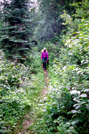 We figured we'd probably see Bill and Will several times during the day and hoped that we wouldn't end up competing with them for a campsite. On the other hand, we enjoyed their company enough that we were not averse to the prospect of sharing a campsite with them, provided there was sufficient room. We mentioned, in fact, that we would gladly have shared our Wavy Rapids campsite with them if they had not seemed so determined to push on.
We still had another round trip on the portage trail to complete; so we finally broke off our visit with Bill and Will and trudged back up the trail. By the time we had portaged our remaining gear, Bill and Will were breaking camp.
The arduous nature of this one kilometer portage raised serious doubts about our plans to do an even longer one mile portage into Brunswick Lake later in the trip. Larry and Doug had been in favor of that portage on the grounds that the lake would provide an interesting break from a long section of the river that promised to be relatively monotonous. Also, there were supposed to be remains of an old Hudson Bay trading post at the north end of the lake. Rob and I had been willing to entertain the idea, but were skeptical whether it was worth the trouble of a one mile portage through mosquito infested woods. In particular, I was willing to go along with the portage if the weather was cool and dry, but not if it was hot and humid. After the Greenhills Portage, Rob and I were confirmed in our desire to avoid the Brunswick Portage, and Larry began to have his doubts.
Once the Greenhill Portage was completed, we quickly reloaded the canoes and paddled out into the confluence of the two rivers, where Rob proceeded to fish for a while. When we resumed paddling, we noticed that Bill and Will had just launched from their camp.
Less than a mile downstream we encountered the next rapids, which had a 550 meter portage on the right. As we scouted the rapids from rocks along the right bank, Bill and Will came up behind us in their canoe. Will joined us on the rocks and agreed with our assessment that the rapids were runnable. Doug and I started the run first, passing through the "V" in the center and continuing downstream in the center through rocky shallows. Larry and Rob were right behind us in the "V", but pulled to the left and found deeper, faster flowing water that propelled them ahead of us.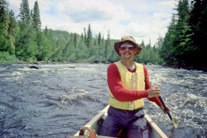 Bill and Will followed them almost immediately, then passed us all as we paused below the rapids to filter water. (My canteen was empty, and the long portage had really dried me out.)
When we reached the next portage, again less than a mile away, we were surprised to find Bill and Will still there. The rapids did not look especially challenging, but they did appear to be pretty shallow. Apparently they were too shallow for the heavier yellow canoe because Bill and Will were in process of portaging. We briefly surveyed the rapids and decided we'd rather run them than portage. During this bit of scouting we noticed some junk along the trail: PVC pipe and the apparent remains of some kind of pontoon raft. The run itself went pretty smoothly, although we did have to dodge some boulders near the end of the rapids.
The next portage was supposed to be 550 meters on the right around rapids that could be run. But the rapids at the start featured a major drop off, followed by a minefield of pillows just below the "V". They did not look safely runnable in loaded canoes. We decided we'd better portage. Rob and I loaded up with gear, started down the trail, and promptly lost the trail. Then we realized we were already past the rapids. The trail was only 60 meters long! Since the portage was so short, we ended up two man carrying the canoes. But now we were all confused about where we were with respect to the map. The 60 meter portage was supposed to follow a 550 meter portage. Where was the 550 meter portage?
We thought the next portage might be the missing one. But features of the river here convinced us we had reached Calf Rapids. The portage trail started in a small bay on the right and more-or less followed the curve of the river 500 meters around to the right. We hiked almost to the end of the trail to look at the lower portion of the rapids and noted that there were apparently more rapids farther downstream. The whole run looked challenging because there were so many rocks in the river, but we didn't see anything especially dangerous. We decided to do the run.
Larry and Rob went first, rounding the curve through a series of "V's", then picking their way through the center of the shallow rock gardens farther downstream. Doug and I started far enough behind them that we lost sight of the route they had taken. We made it through the series of "V's" with no problem, but we couldn't see any obvious path through the rock gardens. We back ferried over to the left bank so that we could scout the remaining rapids. Finally we decided to try the left side of the river the rest of the way. Almost immediately we ran into shallow water and hung up on some rocks. Working our way free, we meandered back toward the center of the river and eventually found enough water to get through to the end.
Now we decided to have lunch. The time was about 1:00 PM. The weather was sunny and warm, with only a slight breeze from the southwest. As we drifted along eating lunch, we kept expecting to see Bill and Will come through the rapids behind us, but there was no sign of them. Meanwhile we had to reposition the canoes several times to keep from drifting into the rapids that led to Split Rock Falls. Just as we were finishing our lunch, we spotted the familiar yellow canoe picking its way through the rock gardens back upstream. We paddled over to the portage trail on the left, then made room for Bill and Will to dock beside us.
The trail around Split Rock Falls was only 200 meters long, but it rose high above the falls, then descended sharply just beyond them.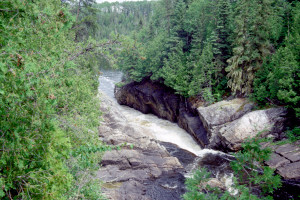 At the crest of the trail was a small campsite with a majestic view of the falls. We briefly considered stopping here to make camp, but decided it was too early. Besides, the campsite was almost too small for two tents, and access to water was somewhat of a problem.
We completed our portage pretty quickly, despite a pause for photographs of the falls, then launched into the river to filter more water. Bill and Will completed their portage shortly after us, then continued on downstream toward Thunder Falls. Since the eight miles to Thunder Falls were pretty much flatwater, we expected them to revert to "race mode" and leave us far behind. The big question was whether we would find room to camp at Thunder Falls. If not, we might have to bushwhack a campsite farther downstream.
This eight mile stretch of river leading to Thunder Falls was a foretaste of the paddling we would be doing for the next two days. The river was winding, relatively free of rocks, and pretty much devoid of any really interesting features. The banks were lined with living and dead white cedars angling out over the water, and behind them were stands of scruffy black spruce interspersed with an occasional birch. The sky gradually clouded up into a high overcast, but there was little indication of rain. The slight breeze died away, leaving the surface of the water smooth as glass. Mirrored in the water, some of the white cedar strainers looked like crocodile jaws and even like prehistoric monsters. We paused a couple times for snacks and pictures.
We reached the approach to Thunder Falls at about 6:30 PM. The approach consisted of two minor rapids the first fairly straightforward, the second requiring some tricky maneuvering through a rock garden and around strainers to get to the portage trail on the right. The trail started on a steep embankment that made it a struggle for us to get the gear and canoes up. Nearby were hints of a cramped, close, mosquito infested campsite.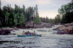 We started to investigate a trail that led back upstream along the bank in hopes that it might lead to a better campsite. No luck. When the rest of the crew turned back, I continued upstream out of sheer curiosity. The trail led all the way back to a spot just above the first rapids. Along the way I noticed both moose and bear tracks in places where the trail bogged down in black mud. At the end of the trail I found an old "sawed off" canoe (the kind used with a small outboard motor) and an ax buried in the side of a tree.
When I returned to the spot where we had left our canoes, I grabbed some gear and started to portage. Rob appeared on the trail and informed me that I might as well take the gear back because we would be camping here. My reaction: "No way. There's no place to put the tents." But he showed me a couple of miserable, weedy places next to the trail where we might be able to fit the tents. The prospects were quite unappealing.
We went to look for Larry and Doug. A narrow trail perpendicular to the portage trail led through stands of white cedar and underbrush out to an open rocky area with large driftwood logs scattered about. Just beyond this area we found Larry and Doug next to the falls taking photographs. Larry pointed out a campsite on the left shore across the bay below the falls: "I think that's the one Ownie was referring to." The campsite was empty ours for the taking. We were all relieved that we wouldn't have to settle for the miserable campsite back at the head of the trail. I asked what had happened to Bill and Will. Larry said he had seen them on the next portage trail, which was over on the right shore of the bay. He figured they would probably take the campsite along that trail, leaving us the site on the opposite shore.
Eventually we finished the portage, loaded the canoes, and paddled across the bay to the campsite. The site was a sandy area beneath towering white cedars. There was room for up to a dozen tents, and most of the tent sites were pretty flat and level. Near the well used fire ring were a homemade bench and a "food prep" table. This campsite would do very nicely.
While setting up camp, we noticed a small dark grey squirrel scampering around the trunk of one of the white cedars chattering away and homing in on my bag of bagels. 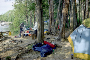 I had removed the bag from my pack while rummaging around in it for my "camp shoes" (the clean, dry ones). I decided to move the food away from the tree. The squirrel lost interest, ascended the tree, and disappeared. We were concerned that the squirrel might get into our trail mix while we were preoccupied with other matters. We didn't see the little rodent again while we were there, although we did occasionally hear it scolding us from the upper reaches of the cedars.
After making camp, we celebrated reaching the "halfway" point of the trip. Doug had brought along a bottle of Black Tower white wine. He poured some into everyone's mug, and we toasted the completion of six days of canoeing. The wine was excellent!
Now it was time for dinner. We had little trouble starting a campfire. There was plenty of dry firewood lying around just about everywhere. In short order we had hot water for the meal. Larry and Rob had Chicken Primavera, Mixed Vegetables, and Apple Cobbler. I had Chicken Primavera and Sweet Corn. Doug started out with broccoli cauliflower soup, then had Beef Stroganoff.
Right after dinner I took a bath. Very refreshing! For the first time on the trip I was able to go to bed completely clean and free of sweat. Before turning in, though, Larry and I loaded the food packs into the Tripper and paddled them out to a rock in the river where they would be relatively safe from marauding bears or curious chipmunks. Shortly afterwards, Doug took a bath in the rapidly fading light. Across the river we could see light from what seemed to be a campfire in the woods. We assumed that was where Bill and Will were camped. We all retired to the tents by 11:00. The level tent sites, distant rumble of the falls, and cool overnight temperature made for ideal sleeping conditions.
Friday, July 15 (Day Seven)
Leisurely morning; rash talk; taking stock; first rapid of the day; bypassing the Brunswick Portage; Fire River confluence; Rob catches and loses a Pike; mule moose sighting; island campsite; fishing below the rapids; dinner conversation; securing the food supplies.
We woke up around 6:30AM, greeted by a temperature in the mid 50's and sunny sky flecked with fluffy white clouds. There was no wind, but there was dew away from the trees a suggestion that the good weather would continue for awhile. Morning routines were more leisurely than usual. Doug started a fire and retrieved the food packs from the rock out in the river. Rob took a bath. I lingered in the tent to update the log. When I emerged, the hot water was ready for cocoa. I noticed that my bagels had begun to mold; so I decided to try using them up as quickly as possible. I scraped the mold off a couple of the bagels, and Rob toasted them for me near the edge of the grate over the campfire.
As we hung around the campfire eating breakfast, we talked about our next "goal". We officially abandoned now the idea of portaging into Brunswick Lake. Instead, we would try for an island campsite the map indicated was about nineteen miles from Thunder Falls. The entire day would be canoeing there would be no need for any portages so we could expect to cover those nineteen miles well before dark.
Rob's "diaper rash" had subsided, apparently helped by the Benadryl cream and an occasional stint of paddling while kneeling with his pants down (a comical sight, needless to say). But now Doug reported a rash on his feet. He thought it might be an allergic reaction to the polypropylene socks he had worn every day so far. I thought it might be athlete's foot brought on by wearing wet shoes all the time. Most likely it was a combination of the two. I suggested he walk around camp barefoot, with maybe some Muskol sprayed on his feet to ward off the beasties. Rob suggested he try the Benadryl cream and maybe a Benadryl tablet at bedtime.
Doug also expressed concern that he might run out of film, bug dope, and toilet paper (much of his toilet paper supply had been soaked when the Penobscot had overturned at Wavy Rapids), and he was mildly alarmed that his food supply seemed to be disappearing so rapidly. The film shortage was easily resolved. My camera was working erratically; so I had virtually stopped taking any photographs.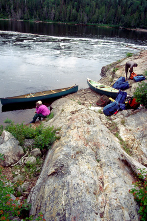 As a result, I had an overabundance of unused film that Doug could use. Bug dope was in somewhat shorter supply, but among the four of us we had enough to make it through the trip. We also had plenty of toilet paper, and ever the good Samaritan, Rob offered to loan Doug some "used" toilet paper. Food was not much of a problem either. We had more than enough for the rest of the trip, although the excess was largely in the form of odds and ends like peanut butter, jerky, crackers, and freeze dried vegetables.
Doug had another complaint that turned out to be common to the entire crew: He was having trouble getting drinking water. His gravity feed water filter was rapidly diminishing in effectiveness. My own water filter was no longer working very well either, and I figured I'd have to clean it at the next campsite. Cleaning would probably solve Doug's problem as well. Larry was having problems with his water filter, too, having to pump forever just to get small amounts of filtered water. But his problem seemed to be more mechanical in nature, and it wasn't clear how he could solve it.
After a relatively uneventful morning, we finally broke camp around 11:15 our latest in several days. At one point Rob thought he saw some people up on the rocks next to the falls, and we became concerned that we might be back in the thick of the competition for campsites. But there was no further sign of anyone. In fact, we wouldn't see anyone for the next two days!
While Rob and I finished packing, Larry and Doug walked downstream to scout some rapids just below the campsite. If we couldn't run the rapids, we would have to paddle over to the other side of the river, unload the canoes, portage past Bill and Will's campsite, and reload. We didn't want to do that. Fortunately the rapids turned out to be runnable, although a bit tricky. The "V" was on the left side of the river not far from our campsite, but the main current pulled over to the right. Just downstream, the navigable water narrowed to a passage between a couple of large boulders in the center, and a rock ledge extended out from the boulder on the right, narrowing the passage still further. We had to follow the current over to the right, then draw left hard enough that the canoes just skirted the boulder on the left. Neither canoe had a problem with the run.
As we passed Bill and Will's camp, we saw no sign of their canoe or their tent and wondered if they might have already broken camp and departed. They had told us they were planning to stay an extra day at Thunder Falls so that Bill could rest. Now it seemed they might have changed their plans. The only other possibility was that their campsite was nestled back in the woods, out of view, and they had pulled their canoe into the campsite. If they had indeed left, though, they would be well ahead of us by the end of the day. Except for rapids at our next intended campsite, the next thirty miles were flatwater just the ticket for their "racing" style of canoeing. What concerned us, though, was that our next intended campsite was the only documented campsite for the next forty miles! If Bill and Will decided to take that campsite, we'd probably have to bushwhack a site in the underbrush along the way.
We continued now on still waters between banks lined with white cedars and lots of strainers. The river was pretty but rather uniform, and except for an occasional duck, there wasn't much to catch our attention. We began to play "trivial pursuit", using material from oldie goldie songs, movies, TV shows, etc. Occasionally Rob would interject one of his off color jokes. We paddled at a leisurely pace, occasionally pausing for snacks.
Just after noon we came upon what appeared to be the Brunswick Portage on the left bank. We had already decided not to portage over to Brunswick Lake, but Doug needed to take a "pit stop"; so we paddled over to shore while Larry and Rob continued downstream to investigate an orange marker they thought might indicate a campsite. When Doug returned to the canoe, he described a maze of trails, seriously bug infested ("with every species of fly known to man"), with plastic gas cans and other junk lying around. As we caught back up with Larry and Rob, we noticed the orange "marker" was just a cracked orange pail lying in the water. There was no campsite here, but there was a small campsite in the weeds on the left bank about a quarter mile farther downstream.
We continued along the river, noting that it looked the same as in the morning. A breeze had sprung up and seemed to shift directions unpredictably. Some stretches of the river were hot and sheltered from the breeze; others were breezy with a tailwind; still others had us paddling into a headwind. Clouds had begun forming in the sky, but the weather was still mostly sunny, and when we had the tailwind, paddling was a real delight.
At about 2:30 PM we came upon the mouth of the Fire River, which flowed into the Missinaibi from the left. We could hear rapids up the Fire River just out of sight, but there was none of the expected moiling and boiling of surface water we associated with the confluence of two rivers. Here we had a tailwind; so we decided to stop for lunch. As we drifted along munching on cheese and crackers, Rob fished, and Larry and I filtered water.
After lunch we continued down stretches of river that looked pretty much the same as before. But at about 3:20, we began to encounter rocks in the river, and up ahead we could see rocky narrows. Soon we began to hear rapids. These rapids were not marked on the map, but they turned out to be easily runnable. Near the bottom, though, we ran into unexpectedly large standing waves that left plenty of water in the canoes.
We stopped below the rapids to bail, then snacked a bit while Rob fished. Almost immediately he caught a two pound pike. He didn't have pliers to pry out the lure; so he had to resort to "surgery" with his knife. But the knife slipped, and instead of cutting the hook out of the fish, it cut the line. The pike dropped back into the water, the lure still stuck to its mouth. The fish paused near the surface as if trying to decide what to do next. Finally it swam slowly out of sight.
As we continued downstream, the river resumed its somewhat monotonous appearance. About an hour later, as we paddled in the shade along the left bank, Doug and I spotted a cow moose that looked like a mule. We alerted Larry and Rob, who were about fifteen meters behind us, but by the time they reached the spot, the moose had retreated into the woods out of sight. Rob then felt obliged to lecture us about the virtue of being quiet when issuing a "wildlife alert" so that others would get to share in the experience. We ignored him.
Soon afterwards we spotted our island objective nestled between two sets of rapids. A portage on the right started in a rock-strewn inlet just out of the current above the rapids. We went down the portage trail just a few feet and discovered a serviceable campsite. But just across the rapids we noticed a more interesting campsite on the island. To get to this campsite we had to "tightrope walk" on a bridge of bleached driftwood logs, part of a logjam just above the rapids.
The campsite turned out to be one of the best we had seen.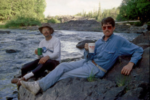 It was high enough to catch a breeze, but sheltered by towering white cedars that also provided plenty of shade. There was easy access to "running water" (the rapids). There were several relatively level tent sites with surfaces of soft cedar "needles". The well built fire ring was partially encircled by logs that would provide good seating. We had a good view of the river, both upstream and downstream. But best of all, the bugs were not bad maybe because of the nice breeze blowing through the camp.
The only problem was that we couldn't expect to portage the canoes and gear across the driftwood bridges we had used to get to the campsite. We would either have to portage the 50 meter trail along the right shore or run the main rapids over to the left of the island, then paddle back up to the campsite below the minor rapids and logjam. We didn't want to have to unload and reload the canoes; so we ran the rapids, which turned out to be relatively straightforward. Just below the rapids we spotted the "mule moose" again over on the left bank. Apparently this stretch of the river was its territory.
Rounding the northern tip of the island, we headed back upstream toward the campsite. The apparent landing for the campsite was extremely muddy. Just beyond the mudflat, though, we found a "rock dock" where we were able to unload the canoes. Getting the gear up to camp was somewhat of a struggle, though, because the bank was so steep above the dock. There was no place to pull the canoes up on shore, so we just tethered them to bushes and roots near the dock.
After we set up camp, I cleaned out my water filter with an old toothbrush I had brought along, then filtered enough water to fill my canteen and Doug's. It was amazing how much easier and more effective the filter became now. Doug was duly impressed and decided to borrow the toothbrush to clean out his own filter. Larry got into the act as well, applying his pocket knife to clean the charcoal filter of his pump. This "operation" improved the pumping action significantly.
Rob wanted to go fishing, and I wanted fish for supper; so we took the Tripper out to fish just below the rapids. We had some trouble finding a spot where it was both easy to keep the canoe in position and deep enough for walleye. On our first attempt we quickly drifted downstream through riffles and ended up having to "tie" the canoe to a large rock in the middle of the river. But the river just didn't seem deep enough here; so we paddled upstream to a large eddy just off the north end of the island. Here we tried fishing for a while, with Rob casting and reeling while I jigged. But the current tugged the fishing lines so hard that we kept getting dragged out of the eddy. Meanwhile the lines snagged and tangled, one of the jigging lures was lost, and one of the rods broke. Finally we just gave up and returned to camp.
Back in camp a nice cedar fire was crackling in the fire ring. We soon had enough hot water for dinner. Rob and Larry dined on Shrimp Cantonese, with Peach Pie for dessert. Doug had a repeat of the Enchilada meal he had eaten the first night of the trip. I had Shrimp Alfredo (my best meal yet), preceded by a couple of demolded and toasted bagels for appetizer and followed by leftover poptarts for dessert.
We talked a bit about the sudden lack of competition on the river. After seeing so many people the first six days of the trip, it was almost surprising to have paddled an entire day without seeing another soul. We wondered what had happened to Bill and Will. Either they had stayed back at Thunder Falls as planned or they had forged ahead at a breakneck pace all the way to Two Portage Falls, which was the next documented campsite, about 10 12 miles away. If they had done the latter, we were not likely to see them again.
Conversation then turned to our objective for the next day.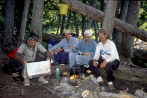 We expected to take about five hours to reach Two Portage Falls, which was supposed to have a "nice" campsite, as indicated by Ownie's annotated map. Then we would encounter a succession of falls, all of which would presumably have to be portaged around. The only other documented campsite in the area was near Devil Shoepack Falls. It was billed as "good", but we weren't sure which was better: "nice" or "good". In any case, the farther we went the next day, the easier would be the day after that, when we needed to get through a twenty mile stretch where there were no documented campsites. If we departed by 9:00 AM the next morning, we could probably reach Devil Shoepack Falls by 5:00 PM that afternoon. We set that campsite as our objective and decided to get up by 6:30 AM the next morning.
After dinner I took a bath in a rocky pool just below the rapids next to the camp. It was great being able to bathe for the third day in a row. But as usual, the bath had to be really quick: By this time the breeze had died down, the light was fading, and the mosquitoes were on the rise.
Now we had to turn our attention to protecting the food packs. The surrounding white cedars were so tall that there were no branches within reach that we could use to hoist the packs. We finally decided to hoist Hellpack on a tree angling out over the mudflat. The rest of the food packs were placed in the Penobscot, which was out in the water tethered to the roots of a white cedar next to the rock dock.
Doug turned in early, after taking a Benadryl for his foot rash and bug bites. The rest of us sat around the campfire talking, but before long the mosquitoes drove us into the tents. Once again we had excellent sleeping conditions: cool, clear weather with the pleasant sound of nearby rapids.
Saturday, July 16 (Day Eight)
Back on the flat, monotonous river; rock islands; wilderness veneer; logging bridge; lunch on the water; idle entertainment; rain and rapids; Brunswick River confluence; portaging and paddling at Two Portage Falls; portage around Pond Falls; short portage at Devil Cap Falls; struggling through the rock garden; camp at Devil Shoepack Falls; failed attempts to hang Hellpack (i.e., Larry competes in the hammer throw).
As planned, the crew arose around 6:30AM. The weather was cool (50 degrees), calm, and clear. During our usual succession of morning constitutionals, Larry discovered another campsite nestled among the trees and underbrush in the middle of the island. We wondered why anyone would want to camp in such close quarters; the bugs here were certainly much worse than where we were camped. We could only surmise that this site would provide better shelter from cold and rain for anyone who was camping in mid spring or early autumn.
We broke camp just after 9:00 AM. About a half mile downstream we spotted the "mule moose" again, this time on the right bank. But we never really got a good enough look at it to determine why it looked so much like a mule. Once we got away from the riffles below the island where we had camped, the river quickly resumed its "same old same old" appearance, winding lazily back and forth and lined with white cedars, black spruce, and various strainers. At around 10:30 we stopped for snacks. In a cloudless sky, the sun had driven away the morning chill. The air was now warm, the water virtually still. But some high, wispy cirrus clouds were just beginning to appear.
Shortly after we resumed, we saw what appeared to be a muskrat or river otter near the left bank. Then we encountered some rapids that were really little more than riffles. As we continued north, we noticed an increasing number of "rock tables" that formed tiny islands in the river. We stopped at one of them around noon for "relief". Then we drifted for a while so that Rob could fish and Larry and I could filter water. Occasionally now we could feel a light breeze, and the cirrus clouds were joined by some lower cumulus clouds.
It was about this time that we really began to notice a phenomenon that we had first encountered on our Mississagi trip two years earlier call it the "wilderness veneer" phenomenon. Now and then we would pass a spot where the riverside woods were broken by clearings on both sides of the river. Through these clearings we could see that the trees only a few hundred meters from the river where relatively new growth mostly maples, aspen, alder as if the forest had been logged over within the past twenty years and was only now beginning to grow back. We speculated that the riverside clearings might have been access points for dumping logs in the river, or possibly spots where the river had been crossed by some kind of logging bridge or ferry.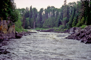 We were somewhat irritated to find ourselves canoeing through what amounted to a veneer of wilderness, especially considering the exorbitant fees we had paid for the privilege of camping in this "wilderness".
At around 1:00 PM we came upon a logging bridge still in use. It looked pretty sturdy for two thirds of its length and even had red painted "ice cutters" on the upstream side that were apparently designed like cowcatchers to prevent chunks of ice, logs, and other debris from plowing into the bridge struts during spring floods. But over toward the right bank the bridge looked rather rickety and skeletal, as if it were either falling apart or under major reconstruction.
Just beyond the bridge we paused for lunch. As we drifted in the bright, hot sunlight, we hoped that a more substantial breeze would spring up or that one of the billowing cumulus clouds would move in front of the sun. No such luck. But at least the slight current and modest breeze pushed us slowly downstream as we ate.
After lunch, we continued through "same old same old". To relieve the monotony, we joked and sang oldies, goldies, and moldies. At one point we had a poetry contest to see who could come up with the best doggerel containing the term "white cedar". As most contest entries were either obscene or obscenely poor, they are omitted from the log.
At around 2:30 a sudden rainshower passed over. Most of the crew grabbed raingear, but I welcomed the rain to cool me off and possibly rinse off some of the odor my clothing had acquired in eight days of canoeing. Soon after the rain, we encountered some rapids, which we ran without scouting. The rain picked up again, and it began to appear that we might have rain all afternoon. But the rain stopped just as we approached some more rapids.
Doug and I were all ready to run these rapids on the left side when we noticed at the last minute that what we thought was a "V" was actually a ledge. The real "V" was on the far right side, slicing in from near the right bank. We quickly back ferried over to that side as Larry and Rob passed us and went on through. Once through the "V", we encountered some hefty standing waves that splashed a fair amount of water into both canoes. But after the earlier stretches of monotonous canoeing in the hot sun, we were glad to trade a bit of bailing for some excitement. Besides, while we were bailing, Rob had a chance to fish. But as usual, no luck with the fish.
Within a couple miles we reached the point where the Brunswick River flowed into the Missinaibi from the left. At this confluence we would have rejoined the Missinaibi if we had made the mile portage over to Brunswick Lake the day before.
Another mile or so brought us to Two Portage Falls, which Ownie had marked on the map as having a "nice" campsite. The campsite was not bad, but we had set Devil Shoepack Falls as our objective; so we decided to push on. Before proceeding down the trail, though, Rob decided to abandon his broken fishing rod in the bushes. We protested that it was a form of littering, but Rob insisted someone else would take it and find a way to use it even in its broken condition.
The 250 meter portage trail was forked, with a left trail leading down to the water just below the main falls and a right trail leading past the campsite down to the end of the rapids beyond the falls. We had started to portage the gear and canoes because we could see that the falls were not runnable; but the rapids looked more promising. We decided to finish portaging the gear but carry the empty canoes down the left trail to the point just below the falls where we could run the rapids.
The run itself was interesting, but not difficult. From the put-in point we had to get out into the current quickly, pass through a "V" on the right side, then pull hard to the left to pass through two remaining "V's" in the center. At the end of the run we had to maneuver through a shallow rock garden, then swing around to the right behind a small island to get back up to the end of the portage trail.
After reloading, we continued for another mile in search of our next portage at Pond Falls.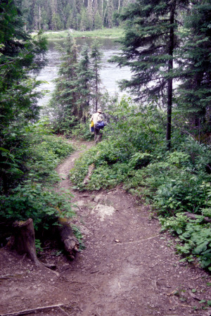 The map indicated that the start of the portage trail was close to the falls, which supposedly dropped six meters; so we wanted to make sure we didn't miss it. We knew we were close when we passed Buchanan Creek, which flowed in from the right. The portage trail started on the right, was about 200 meters long, and led to a rocky, jaggedy spot just below the falls. After we had portaged the canoes and most of the gear, we investigated a trail that branched off to the left from the portage trail and led over to the falls. On the way it passed a small but rather attractive campsite. We were tempted to camp here, but the site did not have particularly good access to water, even though it was near the falls. Also, we didn't want to carry the gear back up the portage trail; and we didn't see a good place to park the canoes. We decided to push on.
Right across the broad pool below Pond Falls was the start of a 125 meter portage around Devil Cap Falls. There was another campsite along this trail, but it was low and muddy and had been pretty well trashed by previous campers (most likely fishermen). Again we decided to press on.
Within a few hundred meters we passed through some minor rapids and then encountered more substantial rapids that we decided to scout.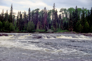 A 450 meter portage trail on the right enabled us to survey the rapids from various vantage points. The run looked fairly straightforward. There was big water in spots, but no obvious pillows or ledges. When we made the run, though, we discovered a rock garden near the end that caught both canoes. Larry and Rob had an especially hard time in the Tripper because Rob was trying to take photographs instead of paddling. We eventually completed the run all right, but had to meander all over the lower portion of the rapids to avoid ledges and submerged rocks in the shallow water.
Another few hundred meters brought us to Devil Shoepack Falls, our objective for the day. The time was about 5:00 PM. The portage trail on the right was about 150 meters long. Only a few meters down the trail we were pleased to find a "good" campsite comparable to the "nice" campsite we had passed up at Two Portage Falls. The site was nicely sheltered by white cedar, black spruce, and birch, but close enough to the river to pick up some breeze and to allow us easy access to water. The "kitchen" area featured a well used fire ring bracketed by logs arranged perfectly for seating. The only drawback was limited tent space. Larry and Rob set up their tent near the kitchen, while Doug and I had to set up our tent on the other side of the trail, partially jutting out into it.
There was plenty of firewood; so we soon had a fire going for dinner. Just beyond the white cedars behind my tent was a rocky outcrop that turned out to be a good place to fetch water free of silt and debris. It was also a good spot to filter water while taking in a view of the rapids. (It wasn't clear why these rapids were called "falls"; they didn't seem to have enough of a drop off to qualify as falls.)
For dinner I had Almond Chicken again (same as Monday's dinner). Larry and Rob had Shrimp Cantonese, and Doug had Sierra Chicken again.
During dinner, we had our usual discussion about the next day's plans. The next campsite was pretty obvious. There were no documented campsites in the twenty miles between Devil Shoepack Falls and Beaver Rapids. From Beaver Rapids it was only about ten miles to Glassy Falls, which was billed as having one of the best campsites on the entire route. From there the distance to Mattice (the end of our trip) was only about eight miles. If we arose early the next morning, we could probably make it all the way to Glassy Falls before nightfall.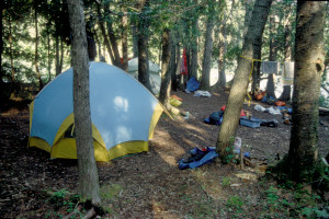 That would ensure we'd reach Glassy Falls before any of our "competitors". But then we'd end the trip the following morning a day earlier than originally planned. We were having such a good time, we were reluctant to shortchange the fun. So the obvious goal for the next day was Beaver Rapids, and we would go to Glassy Falls the day after. At this point, having seen no one else on the river for two days, we were fairly confident we'd beat any competitors to Glassy Falls.
After dinner we went through the usual process of trying to decide where to put the food packs. Larry spent a while recklessly tossing a hammer up into the canopy in a futile attempt to put a line through the crotch of a leaning tree. It was evident this effort was both motivated and undermined by the ample quantity of Dewar's he had consumed. He succeeded only in bashing Hellpack several times and came close to breaking some of the gear in the Duluth pack. Finally we decided just to put the foodpacks down by the landing where we had parked the canoes.
That night we stayed up relatively late (11:15PM) drinking Dewar's and Bailey's around the campfire and generally trying to ignore the mosquitoes. Doug turned in earlier, though, with the drowsy effects of a Benadryl tablet.
Sunday, July 17 (Day Nine)
Morning portage; rapids and riffles; fishermen; lining at Devil Rapids; traversing Albany Rapids; lunch on a rock island; Lower Albany Rapids; afternoon rain; reconnoitering the difficult muddy portage at Beaver Rapids and an alternate trail; choosing a campsite; rough topography at Beaver Rapids; dinner under tarp with mosquitoes; rainy night.
The morning was clear and cool again, with the temperature hovering in the low 50's. As usual, Doug was up first (6:30AM) to fetch the foodpacks and get the campfire going. The rest of us were up around 7:00. After a leisurely and somewhat extended breakfast, we broke camp in a gradual, desultory fashion and were not ready to depart until after 10:00. The first order of business was to complete the portage. Although the trail was only 150 meters long, it was rough and slippery, with a full complement of roots, rocks, and potholes. We were finally ready to launch at around 10:30.
After launch, we cruised through almost a mile of continuous rapids and riffles nothing very challenging, but enough variety to make it an interesting passage. As we emerged from one set of rapids, we encountered a couple of fishermen in a motorboat over near the left bank the first people we had seen in two days! They told us the best fishing was back just below Devil Shoepack Falls where we had camped. We almost hated to hear about the great opportunity Rob had missed for pike, walleye, and bass.
The sky was starting to cloud up now, and the air was growing warmer and more humid. The sun was still in charge, though, and there was only a hint of a breeze.
After running so many rapids without pause for scouting, we were becoming a bit overconfident. As we approached one set of rapids, Doug and I positioned the Penobscot for a run through an apparent "V" in the center, then suddenly realized these rapids might be more than we bargained for. We started to backferry to the right, then noticed that Larry and Rob had veered off to the left. We turned completely around and headed for the left bank, paddling furiously against the current to keep from getting sucked into the rapids. By this time, Larry and Rob had already reached the left bank, which was mostly a jumble of rocks. We joined them, then exited the canoes. From the rocks we could see that the "V" we had almost taken dropped off suddenly into a huge sousehole, followed by enormous standing waves. We had arrived, in fact, at Devil Rapids, which was actually more of a falls than Devil Shoepack Falls. There was supposed to be a 70 meter portage trail over on the right side, but we had seen no portage sign or any other indication of a trailhead.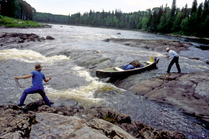 Rather than try to paddle back upstream and over to the other side looking for the portage, we decided to try lining the canoes along the shallow left edge of the rapids, which featured a modest two foot drop.
Larry and Rob neatly lined the Tripper straight through the drop, then pulled the canoe into an eddy along the bank downstream. When Doug and I tried the same maneuver with the Penobscot, it swung out a bit too far, and the current pulled it sideways over the drop. Then the lines yanked it suddenly into a canoe sized inlet just below the drop- almost as if we had swung the canoe into a parking stall! The maneuver may not have looked textbook perfect, but it worked well enough, and from this "parking stall" it was an easy matter to pull the canoe around to the eddy.
From Devil Rapids we passed through another seemingly continuous succession of rapids and riffles. In some places the river was wide enough that both canoes could run the rapids at the same time. Not only were we having great fun; we were also making great time!
At around 12:15 PM we entered a calmer stretch of river, where we decided to pause for snacks and fishing. A more robust southwesterly breeze sprang up now, and clouds began to pass regularly in front of the hot sun.
Shortly after 1:00, we approached Albany Rapids. From upstream we could see no obvious way to go. Boulders were scattered up and down and across the river in random profusion, as if a giant had spilled a great bucket of rocks, and the river looked shallow everywhere.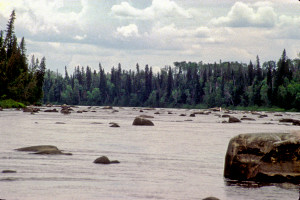 There was no sign of any portage on either bank; so we decided we'd just have to pick our way through this obstacle course. Larry and Rob plunged into the fray and almost immediately hung up on a submerged rock. Doug and I veered to their left but wedged between a couple more submerged rocks. We freed ourselves in short order and continued through this half-mile long rock garden, weaving back and forth to avoid further hang ups. Amazingly we made it through the rest of the course unscathed. Larry and Rob soon followed.
By this time we were getting hungry. We stopped for lunch on a rock island in the middle of the river just past the rock field. This island marked the beginning of an open stretch leading to the lower portion of Albany Rapids. With mostly cloudy skies now and a steady breeze from the south, the island was free of bugs and almost a perfect place for lunch. In fact, this was the first time in six days that we were able to eat lunch without having to drift in the canoe to avoid the bugs.
After lunch, we relaxed on the island for a while and/or explored it a bit. Doug stretched out on the rocks and took a short nap. Larry discovered a bird's nest with four well camouflaged eggs among the grass and scrub bushes. I went rock hopping, trying to follow a series of "stepping stones" in the water that led to a jumble of boulders jutting out of the water just to the east of the island. I slipped into the water several times, though, and finally turned back when I encountered an expanse of water too wide to jump across. Rob fished for a while, but lost the tail of a "weedless" lure to a suspected small mouth bass.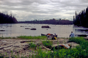 He noted that little stagnant pools in the rocky surface of the island appeared to be filled with mosquito larvae. Fortunately the steady breeze continued to chase away any flying mosquitoes.
We resumed canoeing just after 2:30 PM. In the lower portion of Albany Rapids we passed through a couple more sets of fast water. One of them looked challenging enough that Larry and Rob started to backferry over to the rocky right bank to do some scouting. Before they actually reached the bank, though, Larry decided the run would be OK. They proceeded through the rapids, and Doug and I quickly followed.
The last of the Albany Rapids featured a rock island in the middle, with major drop offs on both sides. We pulled over to the rocks on the left bank to scout, then noticed a more modest and safer looking "spillway" just downstream on the far left. We decided to walk the canoes through this spillway. But the current turned out to be stronger than expected and pulled both canoes through the spillway so quickly that we couldn't quite control them. They wedged against submerged rocks just below the spillway, and we had to struggle to get them free while standing in the rushing water.
Before we got back into the canoes, we noticed that dark clouds were moving toward us from the south. We paused to pull out our raingear, then continued on downstream. Light rain followed within a half hour, then tapered off. The air was warm and humid enough that we removed our raingear. But then the rain started up again. Larry and Rob went ahead and donned their raingear again, but Doug and I hesitated.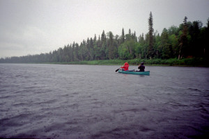 We were waiting for a visible curtain of rain that would really justify the tradeoff (uncomfortable warmth vs. comfortable protection from getting drenched). From time to time we looked behind us for the curtain. Finally it appeared upstream just a quarter mile away. We scrambled into our raingear just in time. It rained more or less steadily for the rest of the day.
At about 5:00 PM we reached Beaver Rapids, where we hoped to camp. After parking the canoes on the left bank, we explored the 300 meter portage trail looking for the documented campsite. The trail was horrible: steep, slippery uphill and downhill sections transformed into mud by the rain and churned to a slippery, treacherous mess by previous portage traffic. There was no sign of a campsite.
About 200 meters down the trail we noticed another trail heading at an angle back toward the south. This trail was narrow, overgrown, and rocky, but it appeared more level and less slippery than the main trail. We followed it to a small squared-off campsite overlooking the rapids. The rapids were actually falls: three meter drops on either side of a long, narrow, rocky "island".
We continued up the trail and came to another campsite, slightly larger but less defined. This site was out in the open, away from any trees, in grass and bushes among the rocks.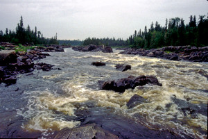 From here the trail continued back to the spot where we had parked the canoes. In effect, we had discovered an alternate portage trail that appeared, under these conditions, to be much safer than the main trail.
We then retraced our steps back to the main trail and continued to the end of the portage, where we found the documented campsite. This site was close, damp, and obviously well used. Rob and I were inclined to favor it over the other two sites because it looked more established and sheltered. (The others looked rather makeshift and were more exposed to the elements.) Larry and Doug wanted to go back to the most open site near the canoes.
We returned to that site and finally came to the unanimous conclusion that it was our best bet because it was most exposed to the breeze, which might provide some relief from the mosquitoes. In these damp conditions, of course, the mosquitoes were absolutely voracious, and we were all forced to wear our headnets. I had a notion to pitch our tent in the squared off campsite near the falls, but decided the tent should be closer to where Larry and Rob were planning to pitch their tent. Later we would use the squared off site for our kitchen and dining room.
Once we had set up our tent, Doug and I separately explored the rocky, slippery, canyon like area below the falls. This entire area was a moonscape: huge jagged shards of black basalt scattered everywhere in crazy profusion, with angular hunks of pink granite and piles of driftwood logs interspersed among them.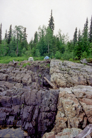 The footing was downright treacherous, and making our way through this minefield in these drizzly conditions was a major challenge. But the awesome ruggedness of the area and the sheer challenge of conquering it proved irresistible.
When we returned to the campsite, Larry and Rob had begun to set up the kitchen/dining room. We strung up the tarp from the smattering of trees around the squared off site, then settled under this shelter to prepare our dinner. The rain continued, soaking any wood we might have otherwise used for a fire; so we started up the stoves to heat water for the meal. Eating was somewhat of a challenge. The mosquitoes joined us under the tarp in great abundance; so we were inclined to retain the headnets. But the headnets interfered with the hand to mouth passage of the food. I still managed to enjoy my Leonardo da Fettucini, and Rob and Larry managed to down a Chili Mac with Beef dish they had prepared. Doug ate another round of Turkey Supreme.
Over dinner, we talked about Larry's experience with son Brent on the Buffalo River, Doug's experience with son Ian on the Sand River, and plans for our next trip, the Lower Missinaibi. We also had our usual discussion about the next day's plans. Our original plan was to go to Glassy Falls the next day, take advantage of the wonderful campsite there, then finish the trip the following morning. But if this nasty weather continued, the Glassy Falls campsite would be hard to enjoy, no matter how wonderful. I suggested that, in case of inclement weather, we might continue past Glassy Falls all the way to Mattice. Rob seconded the motion because he was looking forward now to some of the accouterments of civilization (cold beer, for example) and because he wanted to check on business back at the office. Doug was in favor of it because we could save some vacation time by getting home a day early. Larry was vehemently opposed. He wanted to maximize the wilderness experience come hell or high water. He was willing to go along with a group decision, but he preferred not even to discuss the matter until we actually had to make the decision. We left the matter there.
After dinner, we retired to the tents to escape from the rain and mosquitoes. It was only 9:00 PM, but we were all tired, and there wasn't really anything to do in these miserable conditions. We made no real attempt to secure the food, just leaving it "up for grabs". We soon fell asleep to the patter of rain on the tent walls with the roar of the falls in the background. The steady rain trailed off at about 2:30AM. After that there were a couple more "bursts" of fairly heavy rain. Then the rain stopped altogether.
Monday, July 18 (Day Ten)
Drying out; buggy morning; scouting Lower Beaver Rapids; slips and falls; running the rapids via a small bay and ledges; short vertical portage at Sharp Rock Rapids; Glassy Falls portage trail; beautiful campsite below the falls; thunderstorm; another thunderstorm with hail; a refreshing swim; reunion with Bill and Will; dinner rebellion; pleasant evening.
Dawn brought overcast skies with everything completely saturated. The temperature was about 60 degrees. We all awoke around 7:30, but it was hard to get going when faced with wet dreary weather and hungry mosquitoes just waiting for us to emerge from the tents.
After a quick breakfast of the usual granola and coffee or cocoa, we spread out our gear across the rocks in hope that some of it would dry before we packed for departure. Fortunately there was a steady breeze from the south. The floors of both tents were soaked; so we had to turn the tents upside down to dry them out. Rain had found its way into my riverpack; so I had to drape it on the end of a log extending out over a pile of basalt boulders.
Eventually we pulled everything back together and began to pack. The mosquitoes were horrible, but for some reason the black flies were even worse. In my case, they crawled past the front buttons in my shirt and left a constellation of bites on my chest and abdomen. I sustained more black fly bites between 10:00 and 11:00 that morning than during the entire rest of the trip!
We broke camp at 11:00 and completed the 300 meter portage via the alternate route. After launching the canoes, we paddled over to get a better look at the rapids/falls from below, then proceeded across the bay that separated Upper Beaver Rapids from Lower Beaver Rapids.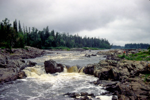 A 135 meter portage trail on the left enabled us to scout the lower rapids. While scouting, I slipped and fell on some sharp rocks in the underbrush and gashed my left hand and elbow and bruised my left hip. This accident underscored the need for me to replace my surf sneakers. I had acquired them for the White River trip and had since used them for a dozen canoe/kayak trips. They had lost so much tread that they no longer provided adequate traction in wet conditions. Larry had suffered similar slips and falls, and for the same reason: his surf sneakers were of the same vintage as mine.
The scouting itself was revealing. The main concourse appeared fraught with hazards: pillows, souseholes, large standing waves. But over on the left side, the river flowed more gently into a small "bay" rimmed with boulders, then dropped over several small ledges into relatively calm water below. It appeared that we could run the left center "V" of the main concourse, then pull to the left into an eddy just past some of the rocks rimming the bay, execute a sharp right turn, then power over one of the ledges.
Larry and Rob started out the run OK and successfully made it into the bay, but then missed the eddy and got hung up on a ledge with too little water. Doug and I started out too far to the right, but managed to pull back to the left OK, skirted the rocks rimming the bay, made it into the eddy, turned right, and powered over a ledge with plenty of water. As we watched from just beyond the ledge, Larry and Rob freed the Tripper, made a couple of unsuccessful attempts to reposition it for a better ledge, then finally achieved the right angle to escape the "trap".
After this adventure we paused for a while to relax while Rob fished. The sun was finally starting to come out, peeking through large white and grey mottled clouds with only an occasional patch of blue beyond.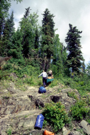 The breeze continued from the south, making conditions increasingly pleasant.
When we resumed, we soon reached Sharp Rock Rapids. These "rapids" were actually falls and were clearly not runnable. A 50 meter portage trail on the left started and ended on jagged basalt rocks that looked like large arrowheads bunched together. As a result, the trail was as treacherous as it was short. We decided to two man carry the canoes. The biggest struggle was just getting the gear out of the canoes and the canoes out of the water at the start of the trail, which was almost as steep as a cliff.
After the portage, Rob once again tried his hand at fishing below the falls. Still no luck. The time was about 1:00 PM. The wind was still behind us and strong enough to blow us north at a good pace. The sun had established more of a presence now, but to the south we could see dark, ominous clouds moving in our direction.
Under way again, we quickly reached Glassy Falls, our destination for the day. The 100 meter portage trail on the right was wide and "groomed" clearly used for off road vehicle traffic. From the canoe landing, the trail extended in both directions along the river. While the rest of the crew proceeded along the trail downriver in search of the campsite, I decided to explore the trail upriver. The trail hugged the river for about 250 meters, then abruptly veered east, heading away from the river and up the sides of the river valley in a meandering, roller coaster fashion. The trail was extremely slippery, and I fell several times, once wrenching my left arm. Eventually I came to a veritable pond blocking further progress. I could see the continuation of the trail on the other side of the pond, but the only way to get to it was by bushwhacking around the pond. The warm, muggy conditions and the increasingly hostile bugs made it hardly worth the effort. I turned around and headed back down to the river.
When I got back to the canoe landing, the crew was returning from the campsite they had discovered in the interim. Rob and I portaged the Penobscot and Tripper respectively to the water's edge across a wide, sandy beach below the campsite. The campsite was beautifully positioned on a modest bluff above the beach and just across a bay from the falls. The falls themselves were impressive- about a four meter drop. The tent sites were somewhat unlevel, but not uncomfortably so. On the whole, the campsite was open and breezy, but a dense woods of spruce came up just behind the tent sites.
While we were still portaging the gear, we had a visit from a groundhog, which snooped around the campsite for a few minutes before Doug tossed a rock toward it to scare it away. We weren't sure whether a groundhog would be interested in our provisions, but given its membership in the rodent family, we decided not to take any chances.
Soon after we had set up camp and begun to hang up our stuff to dry, dark clouds moved in quickly from the south. We scrambled to take everything back off the lines and to prepare the tents for rain. At about 3:15 a thunderstorm broke. While everyone else ducked into the tents, I went for a walk up another one of the "groomed" trails. Since these trails were apparently used by off road vehicles to get down to the falls from the main road, I thought I might be able to walk to the road just for the heck of it. But once again my progress was blocked by a virtual pond about a half mile up the trail.
When I returned to camp (at about 3:50), the sun was just starting to peek out, and the crew was in process of hanging things up again. They were also starting to prepare a late lunch. We ate lunch while sitting on the rocks at the edge of the bluff.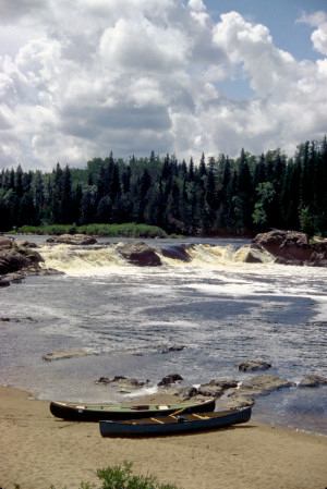 Afterwards, Larry and Rob went out in the Tripper to fish below the falls. Doug went down to the beach to swim/bathe. I grabbed the port-o-john and hiked back up the portage trail to look for a good latrine location.
By the time I returned to camp, dark clouds were massing again. I whistled for Larry and Rob and pointed to the clouds. Then Doug and I began removing things from the lines again and stashing them in the tent. Larry and Rob made it back to shore just in time to do the same. In order to eliminate leakage in his tent, Larry decided to drape a couple of tarps over it. When the storm hit at around 5:00, it brought not only lightning but also hail about the size of popcorn. From inside the tent Doug and I could hear the hail clinking against the aluminum tent poles. Strong winds also blew the tarps off Larry's tent and back into the woods.
The storm passed quickly, but left everything soaked. One consolation: When we unzipped the rear window panel of my tent, we discovered about fifty drowned black flies. These flies had managed to get inside the tent; so they would have feasted on us if they had not drowned.
Now that the storm was over, I resolved to go for a swim. Conditions were warm enough that skinny dipping was in order. The water was delightful, although not far off the sandy beach the bottom was covered with sharp rocks and sticks, making it necessary for me to wear at least my surf sneakers. I bathed for about five minutes, then swam well out into the bay for the next twenty five minutes. Rob joined me about halfway into the swim, then Larry toward the end of the swim. By the time Larry arrived, I was starting to feel pretty chilled; so I swam back to shore, dried off, and donned my camp clothes. Rob and Larry swam for a while until they too started to feel chilled. Afterwards we proclaimed this swim one of the highlights of the trip!
We now set about the arduous task of starting a dinner fire with wood and kindling that had been soaked from the two thunderstorms and the previous day's rain. We had to resort to Larry's fire-starter paste. During one of our several attempts to get the fire going, Will suddenly appeared over on the portage trail. He came over to chat with us for a while, and eventually he was joined by Bill.
We hadn't seen Bill and Will for four days not since Thunder Falls and it had been even longer since we had talked with them. They had spent two nights at Thunder Falls, as planned. On the second day of their stay, the Missouri Party had passed through their camp, informing them that the Toronto Party was not far behind and was planning to stop there. But they had never seen the Toronto Party. The next day they had broken camp earlier than usual and really assaulted the extended, boring flatwater stretch between Thunder Falls and the Brunswick River. They had covered over thirty miles that day, but had been forced to make camp next to the logging road that crossed the river just south of the Brunswick erecting their tent amidst the general clamor of construction work on the bridge.
They now decided to set up camp along the portion of the portage trail that skirted the beach. Their site was actually the "official" Glassy Falls campsite (i.e. the orange campsite sign was posted there). Our campsite although clearly more scenic in its position on the bluff and probably more heavily used was really a makeshift campsite. Meanwhile we gave up on the fire for cooking purposes and instead used Larry's stove to prepare water for dinner.
My dinner was Shrimp Alfredo now one of my favorites. Doug had Beef Stroganoff again. Larry and Rob officially had Pepper Beef, but Rob refused to eat it, resorting instead to leftover and/or unused lunch and snack fare: crackers, cheese, beef jerky, etc. This "protest" capped several days of grousing by Rob about Larry's food selection. Larry's position on the matter was that Rob could have purchased and brought whatever he wanted, but he had turned that burden over to Larry. Now he just had to live with it. After trading the usual Rob and Larry insults, both of them decided that Rob would bring his own food on the next trip.
After dinner we went through the ritual of hoisting the now largely depleted foodpacks out of bear (and groundhog) reach. A lone tree on the edge of the beach provided a sturdy limb for that purpose. Then we settled around the meager campfire to talk and finish off the Dewar's and Bailey's. The evening sky was mostly clear, with an almost full moon in the east. Menacing looking clouds occasionally appeared to the south, but they seemed to drift off to the east without reaching us. The wind died down, inviting the mosquitoes for a feast. I had been wearing sandals all afternoon, but I was now forced to put on socks and shoes for protection from the beasties. Eventually I even had to resort to a headnet. Finally, at around 11:00 PM, we were all forced into the tents. Meanwhile Doug had retired early after taking a Benadryl for his bug bites.
That evening was cool, dry, and very pleasant, with the restful sound of the falls drifting across the bay. At about 3:00 AM I awoke and, through the front window of the tent, observed a really eerie moonset over in the southern sky. The strange colors and shadows cast by the moon made it easy to imagine I was on another planet!
Tuesday, July 19 (Day Eleven)
Another cloudy, buggy morning; Pearl Rapids; running and capsizing at Crow Rapids; recovery after the spill; approach to Mattice; encounter with a film crew; finding Nancy's Restaurant; Owen arrives with beer; final encounter with Bill and Will; showers and a film; pathetic lunch in Hearst; phoning home; dinner in White River; the drive south; key difficulties; the trip ends.
The morning started out clear and cool, but there was an unusually heavy dew. In fact, dew was dripping on my head through the back window screen! We began emerging from the tents just after 6:00AM.
As we ate breakfast and started preparations for departure, we noted with some dismay that heavy clouds were already approaching from the south. Meanwhile the mosquitoes mounted a last ditch, all out assault. It was somewhat discouraging having to resort to headnets so early in the morning.
After packing our gear, we were in the process of hauling it down to the canoes on the beach when Will appeared. We talked with him briefly, remarked that we'd probably encounter him later that day, either on the river or in Mattice, and wished him well in case we didn't see him again. Then we launched at around 8:30. Larry and Rob maintained the same positions in the Tripper they had held throughout the trip: Larry in stern, Rob in bow. Doug and I had been alternating bow and stern in the Penobscot, and it was my turn to take stern position. But my left arm was bothering me so much that I asked for the bow, where I wouldn't have the strain of J stroking to keep the canoe on track.
Just downstream from the campsite we ran several sets of small rapids in succession. One set was a pale imitation of the rock garden at Albany Rapids, but we had little trouble picking our way through it. The sky was now completely overcast, and a light drizzle was settling in. Before long we encountered Pearl Island, which we skirted on the right, and then Pearl Rapids, which we ran without incident.
Our last "hurdle" before Mattice was Crow Rapids. There was no portage here, but the brochure said, "Run with caution". The rapids were spread all across the river, and there was no obvious "best route" through them. Larry and Rob decided on a passage to the left. Before entering the rapids, though, Rob loudly and emphatically reminded Larry that he (Rob) was the "eyes and ears" of the canoe- responsible for scouting out any rocks, pillows, and other hazards ahead of the canoe. Having thus tempted fate, Rob and Larry boldly entered the rapids.
Meanwhile Doug and I had chosen a course right through the center of the rapids. After passing through an initial "V", we appeared to be heading straight for several large boulders. We started to backferry to the left, but then noticed a promising passage between two of the boulders. We powered through this passage, but then had to draw hard to the right to avoid a large pillow.
Doug and I continued downstream a short way until we heard Larry and Rob shouting behind us. We turned around and watched with alarm as they shot over a ledge and frantically struggled to avoid a pillow dead ahead of them.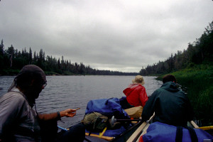 The Tripper hit the pillow, swung around broadside to the current, and then rolled over. We quickly turned around and headed back upstream, collecting water bottles, pads, hats, etc. that had spilled out of the Tripper. We then attached the overturned Tripper to the bow of the Penobscot, transferred some of the gear to the Penobscot, and tugged the swamped canoe laboriously toward shore. Clinging to the side of the Penobscot while treading water, Larry suggested that we try emptying the water out of the Tripper by using the same maneuver we had used to assist the couple from Toronto back at Wavy Rapids. But we were now close enough to the left bank that they would soon be able to stand up. In fact, Rob was able to touch bottom only a moment later.
Once they were both at standing depth, they raised the Tripper enough to empty out the water, then flipped it over and set it back afloat. Then they used the Penobscot as a brace to climb back into the Tripper. Once back in the Tripper afloat, Rob and Larry began to take stock of what had been lost in the spill. The biggest casualty seemed to be Rob's fishing gear, including the tackle box loaded with lures. The tacklebox had not been secured to the canoe and was not the least bit bouyant. Rob was annoyed, of course, but he jokingly remarked that the fish were going to have a regular "lure orgy" at the bottom of the river.
After treading water for about fifteen minutes, both Larry and Rob were cold. Larry wanted to change into some dry clothing before we continued; so we paused along the left bank while he proceeded with that operation. Rob declined to change. He thought his raingear would keep him warm enough, especially once they were paddling again. At this point we were less than four miles from Mattice and would probably reach our takeout point in little more than an hour. So we weren't too concerned about the risk of hypothermia.
About 45 minutes later, in fact, we began to encounter signs of civilization. First, a fleet of canoes and aluminum boats appeared on the right bank. Then we noticed a line of recreational vehicles (campers, motorhomes, etc.) on a ridge above the bank. A bit farther downstream on the same side were some cabins. Then we spotted what looked like a radio broadcast antenna rising above the trees. Finally, rounding a westward bend in the river, we came upon the buildings of Mattice, the Highway 11 bridge, and the Canadian National railway trestle. On the bend itself was a historical site: an Indian burial ground. The site was well above the river, and wooden steps descended from it to the riverbank. Oddly enough, though, the steps ended in a tangle of weeds and reeds rather than in any kind of landing or dock. Doug and I investigated the site from the river, but Larry and Rob pressed on past us toward the town; so we decided not to pursue it any further.
Soon we were passing through the artificial rapids created by the side by side bridge and trestle. We assumed our takeout point would be somewhere beyond the bridge on the right bank, but we weren't sure where. When we came upon a wall of red painted piles lining the right bank, Doug and I decided to land the canoe and investigate. Meanwhile Larry and Rob continued downstream a bit to see if there was a more promising landing.
Climbing over the piles, Doug and I walked up a grassy embankment into what was obviously a park. We were surprised, and rather dismayed, to find ourselves in swarms of black flies here. Nearby about a dozen red Mad River Explorer and Revelation canoes were scattered across the grounds, and a group of people were milling about next to a gravel parking lot just beyond. A middle aged gentleman dressed for outdoor activity greeted us and asked where we had come from. We told him where we had started and how long we had been on the river, then asked about the crowd of people nearby. "Oh, that's the film crew for Backpacker Magazine," he said. "They're about to depart on a trip downriver to make a documentary film about the Lower Missinaibi." Ironically, this film crew was following up on the very magazine article Doug had copied for us before the trip!
We were supposed to call Owen from Nancy's Restaurant and have him pick us up nearby; so I asked the gentleman where the restaurant was. He pointed at a two story building up near the highway that looked to me like an ordinary house.
By this time Larry and Rob had turned around and brought the Tripper back to the red pile wall, which they were now climbing over. Doug and I explained the situation to them, and then we all began unloading the canoes and hauling the gear up next to the parking lot. After we had brought the canoes up next to the gear, Larry asked where the restaurant was.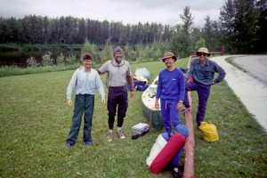 I pointed to the same building that had been pointed out to me. It was the wrong building, of course, but after learning that the hard way, Larry quickly found the right building and made the phone call.
About twenty minutes later Owen arrived with his pickup truck and several bottles of cold Molson's Ice, which we gratefully downed in short order. We told him about the trip and described some of the "discrepancies" we had encountered as we tried to follow the annotated map Ownie had given us in Missanabie. While we were talking with Owen, we noticed that Bill and Will had just arrived down at the red pile wall. Rob and I wandered down to talk with them while they unloaded their gear. Doug and Larry eventually joined us to describe the mishap at Crow Rapids; then Doug took a parting photograph of them just before they hoisted their yellow canoe over the wall. We wished them well, then returned to the parking lot to finish loading the gear and canoes on the pickup truck.
Owen drove us back to his Shallow Lake Camping Park, where we planned to shower and change before starting back home. While transferring the canoes and gear from the pickup truck to the Aerostar, Owen unexpectedly offered to buy my Penobscot for close to what I had paid for it. At first I said no because I had vague plans in the back of my mind to do some more canoeing later in the summer and perhaps to take Chris on an outing the following year. But after talking it over with Doug, I changed my mind. When I indicated that I'd be interested in selling after all, Owen suddenly seemed cool to the idea, suggesting that he needed to talk it over with his wife, who apparently acted as his financial manager. We left for the showers with these "negotiations" still up in the air.
Larry and Doug showered first, but the hot water heater seemed to have very limited capacity because, by the time they had finished, there was no more hot water. I had to take a rather brisk cold shower, and Rob decided to forego the shower altogether. (But then, he had already had a good "shower" in the river earlier.)
After the showers, we drove back to the office/store to view a promotional film on fishing that Owen wanted us to see. Rob had politely expressed interest in booking a fishing trip through Owen's outfitting business; so we agreed to watch the film almost to humor Owen. Owen did not again mention buying the canoe; so we inferred he was not really interested after all. Finally we said goodbye and were on our way home.
The time was about 2:00 PM, and we were pretty hungry. Rob took the wheel, and we drove back to Nancy's Restaurant in Mattice to get lunch. But the restaurant was so preoccupied with serving lunch to the Backpacker Magazine film crew that it appeared we'd have to wait for a half hour. We decided just to drive on to Hearst for lunch.
In Hearst we circled around the "downtown" area looking for a suitable place to have lunch. Curiously enough, we passed Owen's wife and kids, who had earlier come into town to visit the dentist. We finally settled on a little hole in the wall restaurant that had a Pepsi sign out front. The young waitress seemed confused when we asked questions about the menu and had to turn for advice or information to a couple of older women at the table next to us. They all conversed in Canadian French. I could make out and understand some of what they were saying, but I didn't catch the thrust of the conversation. Finally the waitress seemed satisfied, answered our questions, and took our orders.
Rob ordered a hamburger and french fries, which he could have gotten at any fast food place. The rest of us wanted something more interesting and substantial; so we ordered lasagna. But this stuff turned out to be pre made, frozen, microwave heated lasagna. It was rather tasteless and not very filling, and we had to send it back to be heated some more because it was still cold in the middle. Meanwhile Rob happily enjoyed his burger and fries and felt full in a smug sort of way. Ironically, Rob had offered to buy us this wonderful lunch, but when he took out his U.S. currency to pay for the meal, the waitress declined to accept anything but Canadian currency. Doug ended up getting stuck with the bill.
After lunch we crossed the street to a motel/restaurant to phone home and let our families know we had safely completed our trip down the river. Rob called first, but had to leave a message on an answering machine. Doug and I managed to get through to family members: in my case it was Chris. Larry couldn't reach anyone. While the rest of us were making our calls, Rob wandered off to see if he could find another phone from which he could make some business calls. We waited for him for almost half an hour, at various times sending out "search parties" into the immediate neighborhood. Finally Doug found him in another restaurant behind the motel.
Rob now took the wheel and drove us west on Route 11, then south on Route 631 freely engaging in his roller coaster style of driving. I began to feel headachy and nauseated the tell tale signs of another migraine. I tried to sleep it off, but by the time we reached White River I was feeling pretty bad. We stopped at a souvenir shop in White River, then went to an A&W just down the road. I decided to go ahead and eat dinner with the rest of the crew usually a mistake when I have a migraine. But this time eating didn't seem to make me feel any worse at least not right away.
After dinner, Larry took over the driving. We fueled up, then detoured briefly past the White River Trading Post, whose proprietors had provided the shuttle for our trip down the White River six years ago. (we were surprised to see that the Trading Post was now attached to a Chinese food carry out!) Then we continued down Route 17 toward Sault Ste. Marie, which we reached at around 10:00 PM. It was in Sault Ste. Marie meandering through the maze of streets leading to the bridge over the locks that I felt the worst. Once we reached Mackinaw City, I started to feel better. Doug took over the driving, and the rest of us tried to sleep. By the time we reached West Branch, I was feeling well enough to drive. We stopped to refuel at an all-purpose store called "Honkers", where we also bought frozen yoghurt and other treats. I offered to take over the driving, but Doug was feeling really alert and wanted to continue.
We arrived in Brighton at around 4:00 AM. We removed the canoes, transferring the Tripper to the rack on Larry's van, and stacked Larry's and Rob's gear next to the van. Then Doug said his goodbyes and departed for home in the Aerostar. We needed to get into the house to fetch the keys to Larry's van, but I didn't have keys to the house with me, and I couldn't get anyone to answer the doorbell. I thought everyone was asleep, but then the porch light suddenly came on. Still no one would open the door. With some urgency Larry suggested that I knock; so I started banging on the door. Finally Emily opened the door.
Ironically Emily was already getting ready to go to work she was on a new 4X10 schedule that required her to work from 5:00AM to 3:30PM Monday through Thursday and Chris was still up he hadn't gone to bed yet! But Chris hadn't answered the doorbell because he was in the basement where he couldn't hear it; and Emily hadn't answered the doorbell because she thought it was Peter's girlfriend on one of her obsessive attempts to settle an argument with Peter, who wasn't even at home. Emily had turned on the porch light merely in preparation for her own departure for work.
Once the door was opened, though, we quickly fetched Larry's keys, and he and Rob proceeded to load the van and secure the Tripper. They finally left for home at around 5:00AM.
In effect, their departure ended the trip for me with one exception. During our eleven days on the river, I had not shaved. In fact, none of the crew had shaved. After the trip, I decided just to let my beard continue to grow. I thought it would make a nice souvenir of the trip, especially in the dead of winter. But after letting it grow for another six weeks, I couldn't stand it anymore and shaved it off in early September. Now my souvenirs consist of this narrative, a few dozen photos, and large number of scrapes and gashes on the bottom of my canoe!
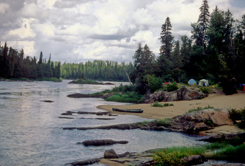
J. Brown
July, 1994
Edits and Summaries:
L. Walter
March, 2006