Chapleau River
Ontario, Canada
June 25 - July 2, 1995
This was the first Canadian trip for my oldest son, Drew, and for his Uncle Steve. It featured plenty of rocky rapids, tough portages, and even some swimming opportunities. The weather was uncharacteristically warm and the black flies and mosquitoes were intense. This is the only river trip in my experience where we mistakenly bypassed a portage necessitating extreme maneuvers to avert disaster. The trip ended in the hamlet of Elsas where we caught a train and rode in the boxcar back to civilization. What more could you ask for on a first trip? This journal was written by Jim Brown. - L. Walter
Saturday, June 24
Introduction; travel plan and limited sleep.
After five extended canoe-camping trips, Chapleau promised to be the first time I would have the chance to get some real sleep before the long, exhausting drive. Instead of assembling as usual at my house on a Friday night after work, we would assemble early Sunday morning. Steve had left Kansas on Friday to drive to Larry's house, and the crew (Larry, his oldest son Drew, and Steve) then departed from Ohio around 10:00PM Saturday, expecting to arrive at my house around 3:00AM Sunday.
The prospect of getting some sleep before the trip was most welcome, but it was thwarted in the usual way by the inevitable weekend commotion around the house. Both Peter and Chris had friends over to visit, and the noise and general hubbub, together with my excitement about the trip, kept me from falling asleep until almost midnight. Still, three hours sleep was better than the complete lack of sleep facing the rest of the crew when they arrived around 3:00AM.
Sunday, June 25
Travel arrangements; windy drive; Thessalon; tent rental; lunch at Aux Trois Moulins; fire ban; launch from the public dock; flora and fauna; Seven Mile Rapids; Henderson Lake; searching for a campsite; island camp; dinner and the failed net tent experiment; campfire strategy.
When the crew arrived, we went through brief greetings and desperately needed pit stops, then caught up on relevant current events while consuming goodies (biscuits, bacon, muffins, and coffee) Emily had made while I was "napping". Then we set about loading my canoe on Larry's custom designed wooden rack. (I had been unable to acquire a lease Aerostar at work that would have allowed us to use the wooden rack Jim Douglass had designed for the Wakami trip five years earlier; so Larry was forced to build and install a new rack on his Toyota Previa.)  We then rearranged the van to make room for my gear.
We departed my house around 4:00AM. The weather was warm, cloudy, and muggy, with just a hint of rain in the forecast. Larry managed to continue driving as far as Birch Run, where we refueled. Then I took the wheel all the way to Thessalon, Ontario. Along the way, we stopped once in Gaylord to have breakfast at the Flapjack Shack (featuring an incredible variety of pancakes), then at a rest stop south of Mackinaw City, then at a gas station in Sault Ste-Marie to fuel. We noticed an increasing amount of fog as we approached the Straits of Mackinaw, and once across the bridge, we encountered a brisk cross-wind that made the van wobble from time to time. The canoes remained secure on the rack, though, and I adjusted the driving to compensate for the wind. The sun peeked through occasionally as we proceeded through the Upper Peninsula and into Ontario.
We arrived in Thessalon just before noon. There we visited the Wilderness Outfitters store where we had stopped on our Mississagi River trip three years earlier. Larry was looking for Muskol insect-repellent-plus-sunscreen, but the store didn't carry the item and in general seemed pretty disappointing in what it offered. Really it was little more than a convenience store with an attached bait shop. One patron of the store informed us a major thunderstorm had hit Chapleau overnight. As we proceeded north on Route 129, with Larry now at the wheel, we saw increasing evidence of this storm as we splashed through puddles on the road. The skies grew increasingly cloudy, and a northwesterly wind remained steady and strong. It appeared we would encounter more bad weather in the Chapleau area -- a typical start to one of these canoe trips -- but nothing more than a sporadic, misting drizzle developed.
The cool windy conditions allowed us to make a couple of unscheduled "pit stops" along Route 129 without fear of attack by black flies. We noticed a profusion of orange hawkweed, wild daisies, and buttercups alongside the road as we headed north. We were tempted to stop for lunch at several places along the way -- including Johnny's Can-Op service station (another familiar landmark from our Mississagi trip) -- but we decided to wait until Chapleau.
In Chapleau we planned to drop off the Previa keys and pick up a token tent at Jean Guy's house. Jean would not be there, and in fact we would never actually meet him during the trip, but his name had already become the object of numerous jokes (mostly puns and double-entendres). The token tent allowed us to avoid the stiff daily camping fee that Ontario had begun to impose on foreigners just prior to our Missinaibi trip the previous year. Rather than pay $10/day X 7 days X 4 people ($280) to the Canadian government, we had to pay only $6/day X 7 days ($42) to the outfitter. A loophole in the law waives the camping fee for anyone who rents "accommodations" from a Canadian outfitter. Presumably the law has cabins and lodges in mind, but as long as the tent could be interpreted as "accommodations", we were within the letter of the law.
When we reached Chapleau, we quickly located Jean Guy's house and the dock where we were supposed to launch, then went to look for a place for lunch. We found a restaurant called "Aux Trois Moulins", which we jokingly took to mean "The Three Stooges' Place". Our waitress informed us matter-of-factly that it meant "At the Three Lumber Mills". She also informed us that, despite the heavy storm overnight, the region had received so little rain in the previous month that there was a fire ban in effect. This information added substance to the yellow "Feux Interdit" signs we had seen along Route 129 and threatened to put a damper on our camping plans, which included cooking dinner over a nice campfire each evening. Questions about the level of enforcement of this ban were quickly put to rest: The waitress said the MNR was enforcing the ban with helicopters, and several people had already been fined $1,000 for violating the ban.
With this disappointing news, we set to work on a heavy lunch, which we thought would enable us to get by with a very light dinner that evening at our first campsite. Larry and Steve went for cheeseburgers, while Drew opted for a pineapple and pepperoni pizza with an extra topping of pineapple. I settled for overcooked fish'n'chips. After lunch, we filled our canteens and water bottles from the tap at the restaurant's ice cream fountain, then set off for Jean Guy's house. We dropped off the keys, picked up the tent, then proceeded to the dock behind city hall. 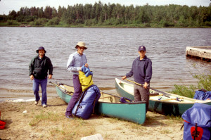 There we unloaded the canoes and gear and changed into our canoeing clothes. As we prepared to launch, we noticed some kids swimming just downstream. The conditions were still cool, cloudy, and windy; so we were impressed with this display of hardiness... until we sampled the water. It was unexpectedly warm -- almost like bath water -- certainly warmer than we had ever encountered before in this area. Apparently the drought that had led to the fire ban had been accompanied by warmer than normal temperatures, and the result was warmer than normal river water. We looked forward to the prospect of being able to swim comfortably on this trip.
We launched the canoes at around 5:00PM. Larry took the stern of the Tripper, Drew the bow. I took the stern of the Penobscot, Steve the bow. We would maintain these positions pretty much throughout the trip. From the very start we paddled into a stiff northerly wind. Progress was also hampered somewhat by the wakes of numerous motorboats. Cabins lined the shore on both sides of the river at the start, but gradually diminished in number as we headed north. Eventually we were flanked by woods and/or marsh, and we began to look for possible campsites. Several promising sites turned out to have isolated cabins on them.
As we continued into the wind, the Penobscot showed its advantage over the Tripper in lake-like conditions. The minimal rocker made it track straighter, and the low profile caught less wind. (These features would become disadvantages, though, once we had to negotiate white water.) Signs of wildlife gradually increased. We encountered a couple of loons, a blue heron, and several beaver lodges. At one point we spotted a small otter hopping along the right bank with a fish in its mouth. Waxy yellow water lilies began appearing in reedy areas along shore, and before long we saw our first blue flag. We also saw more of the now-familiar yellow "Feux Interdit" signs at various points on the left shore. Clouds gradually dissipated, and the weather became more sunny, although the wind remained steady, producing 2-foot waves in more open expanses of the river. There was no sign of black flies or mosquitoes yet, but heavier bugs -- sand flies and deer flies -- managed to cut through the wind to pester us from time to time.
At around 7:00 we passed through Seven Mile Rapids -- actually just a narrows with swift water -- and entered Henderson Lake -- actually just a widening of the river. Immediately we encountered two fishermen in a motorboat along the right shore. We noticed a promising campsite just behind them with no evidence that it was taken. Trying to be discreet, we asked the fishermen if they knew of any good campsites nearby. We hoped they would say, "Yes, right here behind us." Instead, they responded, "On the second island about a half mile downstream." Reluctantly and doubtfully we continued downstream, grousing that they had probably given us a bum steer just so we wouldn't spoil their fishing. About a half mile downstream, we saw no island, but we did notice a point on the left shore that looked like a prospective campsite. Larry and Drew put in to shore and investigated the site but found that it lacked enough level tent space. We continued downstream another half mile and, to our surprise, found the recommended island. It was small, oval, nicely treed with birch and spruce, and had a high backbone up in the breeze. There was adequate tent space, though not especially level, and access to the site was up a steep, eroded, sandy bank on the south side. Obviously the site had seen regular use, presumably by fishermen. The east end of the island featured a fire ring, the west end a pile of bear droppings. 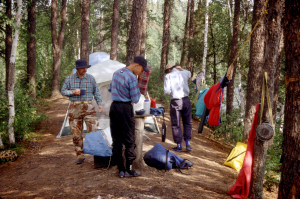 We decided to site our tents between these two points.
As we unloaded the canoes, we discovered sudden swarms of mosquitoes along the water's edge. They were protected from the wind by the island's high profile, but they managed to follow us up into the breezier campsite and were soon joined by a complement of black flies. We donned our headnets and applied bug dope for the first time.
Much like the canoe positions, our tent arrangements remained the same through the entire trip. Larry and Drew slept in Larry's veteran Sierra Designs Octadome tent, Steve and I in my Eureka Overlander. Since my Therm-a-Rest was full-size and Steve's was only half-size, Steve slept on the side of the tent where the door-flap opened, and I slept on the other side. As we set up the tent, though, we encountered a problem that would plague us the rest of the trip: The vertical door zipper kept separating, leaving the door open to the elements -- and of course to the bugs! Only by slowly and carefully zipping the door shut could we prevent the separation. But slowness and care are difficult to manage when you are desperately trying to escape into the tent from hoards of voracious mosquitoes and black flies.
After setting up camp, we were more tired than hungry; so we decided to forego the planned dinner of Cajun Chicken and just eat snacks: garlic bread crisps, gouda cheese, jerky, and granola bars. Larry had acquired a "net tent" which he thought would afford us protection from the bugs while we ate. We set up the tent in the "kitchen area" of the camp, but immediately discovered the tent's drawbacks. Larry had chosen a small tent (inexpensive and light to carry) without a floor (so we could quickly and easily get under the net while pursued by hoards of bugs). The problem was that it was difficult to put the tent down anywhere without trapping a fair number of bugs in it with us, and once we were "in" the tent, the sides kept rising up off the ground, allowing more bugs to enter from below. Meanwhile, we found the tent so cramped that we could not get into a comfortable position for eating, and the very attempt to relieve the cramped conditions tended to raise the sides off the ground, allowing still more bugs to enter. We stuck with the tent for the entire meal, but used it only once more (with even less success) during the trip. Clearly a good idea that needed some work!
Normally after dinner we would have sat around the campfire and talked. But the fire ban ruled that out, especially given the fact that we had heard the sound of patrolling helicopters at least twice since we had arrived at this campsite. Camping without a campfire seemed almost intolerable, though, so we decided to formulate a campfire strategy. Tonight we would turn in early because we were so tired after the long drive. But on subsequent nights we would start a campfire only after darkness had fallen -- so the smoke could not be seen from the air -- and only at campsites that were sheltered from view by surrounding trees and underbrush. Then we would have a tarp and water bucket ready to extinguish the fire the moment we heard the sound of helicopter blades.
As darkness fell, the breeze died down. The black flies gradually disappeared, but the mosquitoes grew bolder and more numerous than ever. We briefly entertained the notion of hoisting the food packs out of bear reach, but the island was so small, there were no obvious tree limbs from which to hang the packs, and we were too tired to conduct an exhaustive search in the gathering dusk. We finally decided just to wedge the packs between two trees away from the tents. We retired to the tents around 10:00PM. After a brief bout of bug-bashing to eliminate stray mosquitoes and black flies inside the tents, we quickly fell asleep to the omnipresent sound of mosquitoes whining in the darkness and the distant call of loons farther downstream.
Monday, June 26
Breakfast; D'Arcy Lake; portage to Robinson Lake; rapids; bear cub; tough portage; lunch on the water; high rocky campsite; camp activities; bathing, swimming & diving; firewood from the beaver lodge; fire and mosquitoes.
Overnight the wind died down completely, and the sky cleared. But the temperature did not drop as much as we would have expected with clear skies, and the humidity remained uncomfortable.
In the morning the tents were covered on the outside with hungry mosquitoes. The sun was shining, and a northerly breeze had sprung up again. Out on the water we could hear ducks cavorting. The island was not far from shore, and in the nearby woods we could hear woodpeckers and a rich variety of bird calls. At about 7:30AM a motorboat passed slowly by the island, presumably taking fishermen to their favorite spots downstream. We began exiting the tents around 8:30.
Breakfast this morning, and every subsequent morning, consisted of bagels (until they ran out), coffee-or-cocoa, and granola-or-oatmeal. This first morning of camping we were not terribly well-organized; so it took a while to get through the various morning routines and into a camp-breaking mode. Eventually we were able to launch by 11:00AM.
With a fairly good night's sleep behind us and a beautiful day ahead of us, we were in pretty good spirits, despite the fact that we were again paddling into a steady northerly wind. 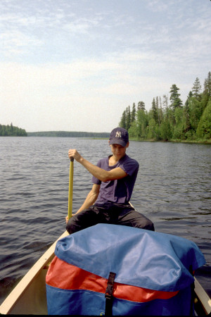 After about an hour's paddling, we passed through another narrows into D'Arcy Lake -- again just another widening of the river. The terrain varied little from the previous day: reeds at various points along the shore, occasional clumps of water lilies, mostly black spruce or alder along the banks, with birch higher up.
At around 1:00PM we came to our first portage. The rapids here would probably have been runnable, except they were blocked by a logjam. The 225 meter portage trail rose gradually to the crest of a heavily wooded hill, then dropped more abruptly to Robinson Lake. The portage was relatively easy, and the bugs were not bad. Once out in Robinson Lake, we paused to filter water and snack on granola bars and trail mix.
At the other end of Robinson Lake we encountered rapids which a 90 meter portage trail supposedly circumvented on the left. We couldn't find the portage trail, but we didn't look very hard because the rapids were easily runnable. Once past the rapids, we were again officially on the Chapleau River. Almost immediately we spotted a small black bear (evidently a cub) drinking water along the left bank. It quickly scampered back up into the woods.
Soon afterwards we came to Portage #3, 290 meters on the left around a set of 4 rapids. The rapids were in a left bend in the river, and the portage trail cut more-or-less straight across the bend; so there was no way to scout the rapids without major bushwhacking. Drew was champing at the bit to run some real rapids, scoutable or not, and he would maintain this gung-ho youthful enthusiasm in the face of stodgy old reason and common sense for the whole trip. But this time common sense prevailed: We decided just to portage.
The trail here was much tougher than Portage #1 -- lots of roots, rocks, ruts, and moosemuck -- and the bugs were considerably more bothersome. We were anxious to launch out into the breeze, but discovered we were missing a bungee cord. Steve said he had seen it near an especially swampy spot near the start of the trail but couldn't pick it up because he was carrying the Penobscot. I returned up the trail, found the cord, then continued to the trailhead to make sure we hadn't left anything else. When I returned, the crew was more anxious than ever to get away from the bugs. We launched, then stopped in open water for lunch. 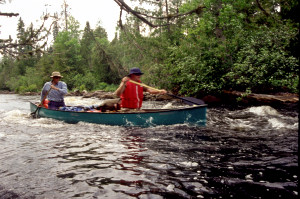 But the breeze wasn't strong enough here to blow away the bugs; so we paddled farther downstream before resuming our lunch. Lunch consisted of granola bars and peanut butter and jam on bagel crisps.
As we continued downstream, the sky began to cloud up -- which brought welcome relief from the hot sun -- but the breeze also began to subside. It was still early, but we decided to start looking for a potential campsite, since no campsites were marked on the map until Portage #9, which was well beyond our reach for this day's paddling. We thought we might end up having to bushwhack a campsite, but at about 5:30 we found a good prospect on the left bank, just past a beaver lodge.
A rock landing, offset by a large log extending out into the river, formed a convenient dock, and to our surprise there was a blue plastic marker on a tree near the water indicating an "official" campsite. A quick investigation revealed a well-used campsite that had apparently been created by clearcutting a rocky embankment. Much of the ground consisted of large hunks of granite covered with crunchy moss and lichens, but there were a couple of OK tent sites. The "kitchen area" had a large and carefully crafted hearth -- about the nicest one we had seen on any of our trips -- and next to it was a rock "porch", about two meters above the water, with an impressive view downstream. The site was high enough to catch a breeze, but the breeze was not strong enough to keep away the bugs. Steve and I set up our tent in a bunchberry garden extending just into the woods. Larry and Drew found a tent site on somewhat higher ground in the open. Both tent sites were level, but not very even.
Once the tents were set up and clothesline strung among the trees for drying and airing out our stuff, we went about our separate pursuits. 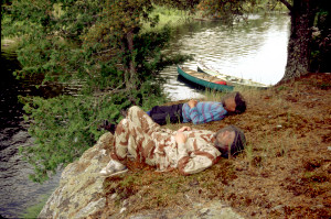 Drew and I each made use of the portable latrine for the first time. Then Drew took the canoe out into the river to escape the bugs. I worked on the log for a while, but the bugs forced me to stroll about the campsite as I wrote. Steve stretched out on the "porch" and dozed with his headnet on. Larry also took advantage of the porch, settling down in his camp chair on the "porch", fortified against the bugs with double-barreled headnet, nylon shirt, and a cup of Dewar's scotch. While pouring the scotch, he dropped the cap of his scotch canister into the water below. Drew paddled over to retrieve it but couldn't reach far enough down into the water. Eventually I climbed down the rock face into the water, rolled up my sleeve, reached down among the submerged rocks, and grabbed the cap.
Afterwards, since I was already wet, and the water was pleasantly warm, I decided to go for a swim/bath. But the only clothing I removed was my shirt. I kept my water shoes on to protect my feet from, and provide some traction on, the sharp, slippery rocks; and I kept my pants on to wash out the moosemuck from the earlier portage. The swim was very refreshing while it lasted, but then I was faced with the daunting task of removing the wet clothing, drying off, and putting on dry clothing while surrounded by voracious black flies and mosquitoes. I accomplished the task, but not without casualties. As I got dressed, Drew decided to go next, and in short order he was in the water. He discovered that our "porch" made a great "high-dive" platform; so he began climbing up the rock face and leaping into the water. 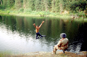 He was having so much fun that I almost decided to go back in the water and join him.
The sky gradually cleared as evening approached, and the breeze died down to almost nothing. The bugs grew steadily bolder and more numerous. Eventually we ate dinner: Cajun Chicken, peas, and cheesecake. Then we decided to have a campfire. First we needed firewood; so Drew paddled over to the beaver lodge just upstream and began pilfering wood from the beaver. He made a terrific racket throwing the wood he selected into a pile by the canoe, then loading it into the canoe. After Drew returned to the campsite, we watched as the beaver swam out to inspect the damage to his roof. (He must have decided to wait till we were gone before undertaking any repairs.) Drew then fetched some douse-water in the flexible bucket and set the tarp next to the hearth. We were all ready to implement our campfire strategy.
Soon we had a fire crackling merrily in the hearth, with just enough smoke to bother our eyes, but not enough to keep the bugs away. As darkness fell, we suddenly heard an airplane motor. Drew tried to douse the fire, but only managed to put out half of it. The motor sound gradually faded, though; so we decided to keep the fire going. As we sat and stood around the campfire, the gathering darkness made it hard to see anything. But we could hear the steady whine of millions of mosquitoes building to a crescendo in the woods; and if we flailed our arms, we could feel the hundreds of mosquitoes that formed a literal cloud right around us. At around 11:00 we decided it was time to retreat into the tents.
Earlier we had set fire to coils of PIC insect repellent in the tents. The idea was to liquidate any bugs that had entered while we were loading our sleeping gear into the tents. Now the tents seemed clear of the little beasties -- except for a few stray ones that entered with us and which we eliminated by the traditional swatting method. What we didn't realize was that some of the little beasties had escaped from the PIC by hiding in our sleeping gear. Those we discovered next morning -- gorged with blood, of course.
Sleep was difficult this night because the air was still, warm, and humid. I decided to try making it through the night without my sleeping bag, but by 3:00AM the air had cooled enough to force me first to use my spare clothing as a blanket and finally to resort to the sleeping bag. The omnipresent whine of mosquitoes continued through the night, broken only by the sporadic "gallumph" of bullfrogs in the marsh reeds downstream.
Tuesday, June 27
Sleeping late; other canoeists; shallow rapids and partial portage; portage trail and two waterfalls; multiple trails around rocky rapids and ledges; tortuous 585 meter portage; encounter with the three MNR canoeists; moose sighting; 215 meter portage ending in mucky morass; portage around a chute and a painful "knee walk;" an unpopular campsite; viewing the waterfall; dining with the mosquitoes; late fire; fretful sleep.
In the morning the weather was overcast, pleasantly cool, but unpleasantly muggy. I initially awoke to a loud buzzing sound at the top of the tent. I couldn't see what was making the noise, but Drew later mentioned that from outside the tent he could see a huge black fly buzzing around the tent fly. (It was ironic, I suppose, that the fly seemed to be attracted to its namesake!) Meanwhile, the usual hoard of mosquitoes perched hungrily on the windows of the tent, waiting for us to emerge. I worked on the log for a while, but when Steve showed no signs of getting up, I just went back to sleep. We didn't leave the tent until almost 10:30! By that time the overcast was beginning to break up, and the air was warming pretty quickly. Breakfast was already under way. We consumed the usual fare, then set about breaking camp.
At about 11:30 a man and two women passed by our campsite in a canoe. They continued downstream and were out of sight when we finished breaking camp at 12:15. This sudden appearance of canoeists, together with our tendency so far to break camp really late, caused some concern. We now had apparent competitors for potential campsites; and if we continued to break camp so late in the mornings, we stood a good chance of losing out on the best campsites.
Once under way in the canoes, we noticed that the wind had shifted. Instead of a headwind, we now had a tailwind as we continued north. The breeze was not strong enough to give us much of a push, but the southerly flow promised to make the warm, humid conditions even less comfortable. We began to hope the sun would stay behind the clouds as much as possible.
Soon we passed Racine Creek (which flowed into the Chapleau from Racine Lake to the west) and reached Portage #4, 65 meters on the left. 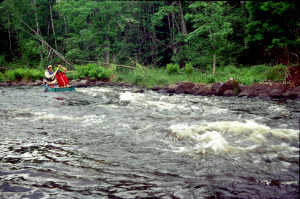 The rapids here looked shallow but runnable. We decided to portage the gear, then run the rapids in empty canoes. The canoeists who had passed our camp earlier were just ahead of us -- somewhat to our surprise -- and appeared to take the same approach -- portaging the gear and running the rapids empty. But we saw only the man and one of the women in the canoe -- as if the other woman had declined to run the rapids. We never saw her get back into their canoe, but when we reached the end of the portage trail, where we should have encountered her, she was not there.
We reloaded the canoes, continued downstream, and soon reached Portage #5, a 250 meter trail on the left around rapids with two waterfalls. Parts of the trail passed through deep moosemuck, but we wanted to see the falls; so after we had portaged the canoes and gear, we returned back up the trail and bushwhacked down to the noisiest part of the rapids. There the river dropped 2-3 meters in a thunderous rush of white water. We lingered for a few minutes, trying in vain to find the best camera angles to capture this dynamic scene. Then we returned to the end of the trail and continued on our way.
In short order we reached Portage #6, a 110 meter trail on the right. We attempted to scout the rapids here, but they were too long to survey from the head of the trail, and there were no convenient points along the trail where we could bushwhack over to take a closer look at the water. From upstream, though, it appeared there was a ledge all the way across the river about halfway down the rapids. We briefly considered lining the canoes, but there were few spots along the banks where we would obviously be able to walk, and feeling our way downriver along the shore would take too long.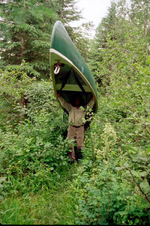 We decided just to portage.
We were barely under way again when we encountered Portage #7, a 100 meter trail on the left around rapids that were too rocky and shallow to run, and Portage #8, a 80 meter trail also on the left. These two portages were so close together that the trails were connected, making them seem like one continuous trail. As a result, we lost count of the portages.
Meanwhile, the weather turned variable. One moment it would be warm and sunny. Then the sky would cloud over. Then we would feel sprinkles of rain. Then the sun would be out again making us warm and uncomfortable.
Portage #9 was just downstream and also on the left. As we approached it, we thought it was actually Portage #8 and expected a mere 80 meters of trail. Steve and I hoisted Hellpack and the Tripper respectively, thinking we'd have an easy time of it. Instead, the trail turned out to be 585 hilly, tortuous, overgrown, and buggy meters of rocks, roots, and ruts, interrupted by fallen trees and interspersed with long stretches of moosemuck overlaid by ill-placed and slippery "logwalks". It was one of the toughest trails we had encountered on any of our canoe trips!
Shortly into the trail, we encountered the three canoeists we had seen earlier. They had already made camp for the day in a cramped, close, and brushy area just to the left of the trail. They were seated on the ground, apparently eating dinner, and surrounded by smoking coils of PIC. Amazingly they were not wearing headnets. Inititially we just said hello as we passed down the trail, but later we talked with them briefly as we returned up the trail to get the rest of our gear. It turned out they worked for the MNR and were heading up to Schewabik Lake on a bear research expedition. We wished them luck, then completed our portage, hoping that we would not have to settle for a campsite as uncomfortable-looking as theirs.
It was still early, not quite 4:30, when we finished the portage and resumed our course down the river.  But we began to wonder how much more progress we'd be able to make -- especially with all these portages in the way -- before we'd have to give serious thought to making camp. For the time being we had somewhat of a respite from portaging as we continued north along a straight stretch of the river. At one point we saw a moose with an impressive rack of antlers browsing in the reeds along the right bank. He waded and swam across the river to the left bank as we approached, then lumbered up into the woods and disappeared.
At about 6:00 we came to Portage #10. The rapids here were long, shallow, and rocky and extended around a bend to the right. The 215 meter portage trail cut across the bend, but presented no easy access to the water for scouting. Rather than spend the time bushwhacking to a good survey point beside the rapids, we decided to go ahead and portage. The trail was all right for most of its length, but it ended in a mucky morass that forced us to carry the gear and canoes through underbrush and around several tree trunks to get to a spot where the canoes could be loaded. Such extra maneuvering was not welcome at this point. We were getting tired of all the portaging, and with each portage the bugs seemed to grow worse.
Soon after we launched from this morass, we encountered Portage #11. A 225 meter trail passed to the right around a steep narrow gorge that turned the river at this point into an unrunnable chute. The salient feature of this trail was a fallen tree near the end that crossed the trail at about shoulder height. It was too low to carry the canoes under, but too high to pass the canoes over.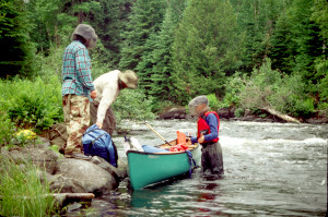 Larry and I, who carried the canoes this time, were forced to drop down and "knee walk" under the tree for a couple meters -- a rather painful exercise considering the sharp rocks embedded in the trail.
At the end of the trail was a small, close, breezeless campsite with a marshy, mucky area right in the middle. It was 7:15 by the time we finished portaging. Since the next campsite marked on the map was a good 4 miles away, Larry proposed that we stop here to camp. I was immediately opposed to the idea because the site looked miserable and bug-ridden, there appeared to be room for only one tent, and even that limited space was unlevel and lumpy. The only positive aspect of the site was its proximity to the rapids, which produced a pleasant white noise that would be good for sleeping. After all the portaging we had done this day, I was ready for some uninterrupted canoeing; so the 4 miles to the next campsite did not phase me even though I was tired. Steve felt the same way and was fully ready to go on. Drew didn't like the site because there was no place to swim.
But Larry held all the trump cards. He pointed out to Drew that by the time we reached the next campsite it would be too late to go swimming, even given a decent place to swim, and if we continued on, we would have no opportunity to view the magnificent waterfall/chute we had just portaged around. The prospect of visiting the waterfall seemed to change Drew's mind about staying. Then Larry observed that there was no guarantee the next campsite would be any better than this one. In fact, it might be worse because it was near a logging road and was therefore easily accessible to local fishermen and others who were likely to have trashed the place. 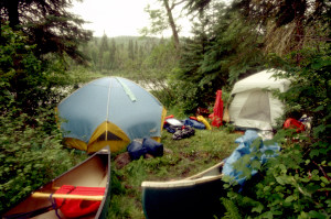 It would probably also lack the restful sound of nearby rapids. As for the lack of space, Larry was convinced we could carve an extra tent site out of the underbrush along the southeast perimeter of the campsite, and to demonstrate his hypothesis, he put Drew to work chopping away the weeds, bushes, and sapplings there. I had to admit the space he cleared was a feasible tent site, though just barely. But the leftover stubble appeared sharp enough to pierce both of my tarps and the floor of my tent. Larry offered one of his heavy-duty tarps to go underneath my usual setup for extra protection, and that pretty much solved the stubble problem. But nothing could solve the problem of lumpy ground -- we'd just have to grin and bear it. Eventually Steve and I decided we'd like to see the falls, too, and as much as we disliked this campsite, we did not relish the prospect of having to make camp in gathering darkness at some unknown later site. We weren't going to be happy campers, so to speak, but under the circumstances we could live with this miserable site.
After setting up the tents, we hiked back up the trail to a small clearing near a stand-alone fir tree that almost looked like an overgrown foundation shrub on a residential lot. It appeared this spot might have been used occasionally for a campsite, perhaps in cooler months when protection from the wind was more desirable. From here we bushwhacked over to the falls through a jungle of white cedars and black spruce. The falls were impressive, with white water surging through a long, narrow, rocky chute that dropped almost 10 meters from start to finish. Larry and I picked our way through the undergrowth at water's edge both up- and down-stream looking for good camera angles, but as usual there was no way to capture on film the power and dynamic nature of the river at this spot. 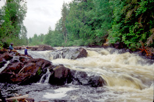 Meanwhile, Steve took a more practical approach to the scene, removing his boots and socks to soak his feet in the cool water, while Drew tried to turn the place into a water park, wading in an adjacent pool and immersing his head in a small cascade. Eventually we all began to get hungry and decided to head back to camp to prepare dinner before dark.
We ate at about 9:30. Dinner consisted of red beans and rice, garden vegetables, and mocha mousse. Eating was more of a challenge than usual because the mosquitoes were so bad here that we had to keep our headnets on, and the light was fading so quickly that we couldn't see the mosquitoes when we lifted the headnets to take bites of food.
After dinner, Drew started a fire. There was so little room in the campsite that the fire ring was right next to Larry's tent. Larry was obviously torn between the almost mystical appeal of the campfire and the more concrete desire to protect his tent from sparks and embers. Rather than put out the fire, he took to standing between it and the tent, using his body as a kind of shield.
The main topic of conversation around the campfire was the fact that we were now behind schedule -- partly because we had not been able to run as many of the rapids as we had hoped, but also because we had so far shown a woeful tendency to sleep late into the morning and break camp near or after noon. We couldn't afford to continue this habit because we would not be able to get back on schedule spending only 6-7 hours a day on the river. Getting up late the next morning would be especially bad because the MNR canoeists would have to portage right through the narrow confines of our campsite. We resolved to get going early the next morning.
We enjoyed the campfire for only about half an hour. By this time it was almost 11:00, and everyone was tired from the 8 portages we had tackled that day. We all decided to turn in. Drew doused the fire and then, mindful of the MNR canoeists just behind us on the river, threw the half-burnt firewood out into the river to remove any evidence of a campfire. Meanwhile, we had one remaining task to accomplish: stashing the food packs. It was too dark now to look for a sturdy limb or crotch from which to hoist the packs; so we decided just to take the packs up the trail away from the tents. If a bear devoured our food supplies at this point in the trip, we could make it back to Chapleau within two days -- hungry, but not starving.
Once in the tents, we went through the usual ritual of whacking mosquitoes that had managed to get in. Then we settled down for a less-than-restful night of trying to sleep while tossing and turning on the lumpy, uneven ground. Eventually the sound of the nearby rapids lulled me to sleep, but Steve was never able to get comfortable enough to enjoy that luxury.
Wednesday, June 28
Brave beaver; campsites we might have had; confusing portage trail; difficult 595 meter portage; Steve wrenches his knee; lunch among the cedars; more portages leading to Schewabik Lake; moose sighting; sandy spit campsite on the lake; pre-dinner swim; dinner without a fire again; besieged by mosquitoes; moose in the night.
Once again it was warm enough that I tried sleeping through the night without my sleeping bag. But again the humid air became chilly enough by 3:00AM that I had to release the sleeping bag from its stuff sack and pull it over me like a quilt. By "sunrise" the air was still cool and humid, but there was no sun: the sky was again overcast. Larry issued a wake up call at around 7:30, but I was already working on the log at that point. We all managed to exit the tents by 8:00.
After a quick breakfast, everyone in succession took a "morning constitutional". It was hard to find an acceptable place to go because the undergrowth was so dense in every direction, especially along the portage trail. I managed to locate a passable opening in a spruce grove about two-thirds of the way back up the trail. The mosquitoes were bad there, but then they were bad everywhere along this portage trail.
We broke camp at around 10:00, still a bit late, but much better than the previous two mornings. Shortly after launching, we spotted a small beaver crouched on top of its lodge along the right bank. We expected the beaver to drop into the water, or at least retreat into the bushes behind the lodge, but it just sat there staring at us as we passed.
The sky remained overcast, and for the time being the air remained cool, though humid. We continued to receive a slight push from a moderate southerly breeze.
About a mile downriver from the campsite we had just left, we noticed another campsite on the right shore. This campsite was not marked on the map, but it was obviously larger, more open, more level, and more breezy than the one we had just suffered the night through. We were discouraged, but not surprised, at having missed out on this nice campsite. We had already resigned ourselves to Murphy's Law in such matters.
After about 45 minutes, we reached Portage #12, where the effects of Murphy's Law were again evident: Here was a nice large, open, level, breezy campsite nestled among the jack pines above the right bank. Contrary to our concerns the night before, the site had not been trashed by fishermen or beer parties, although it was clearly well-used.
After unloading the canoes at the fairly convenient landing, we began to look for the portage trail. Our Chapleau brochure said the 225 meter portage trail went "straight across a logging road and through a low thicket." The only trail we saw looked like an ATV track heading north away from the campsite. It dipped down into mud puddles, then rose to join another track that extended more east-to-west. This second track was covered with grass and weeds, and at first we thought it might be the logging road mentioned in the brochure -- perhaps an old logging road that was no longer used. But there was no indication the first track crossed the second. We turned left onto the second track, and after about 50 meters we came out on a gravel road -- obviously the real logging road. 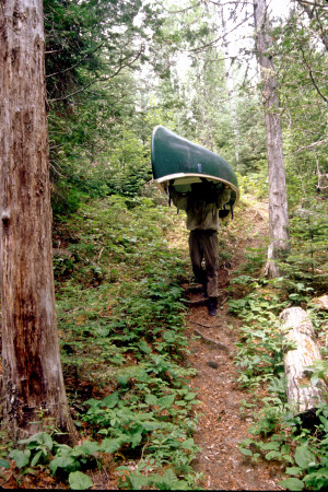 But again, there was no indication the track crossed the road. We turned left once more and headed down toward the river, figuring we'd probably have to launch at the base of a bridge we could see just down the road. But after another 50 meters, we noticed some colorful ribbon in a branch extending from the right side of the road. Here finally was the continuation of the trail "through a low thicket". Apparently the portage trail had once run closer to the river and crossed the road at this point. But once the ATV tracks had been forged into the campsite, the portion of the portage trail south of the road had fallen into disuse and had eventually disappeared in the undergrowth. We managed to locate part of this old portage trail as we returned to fetch the canoes and our remaining gear.
The portage trail ended in a jumble of rocks along the river, but the rocks did not interfere with our efforts to reload the canoes, and we were soon on our way. The sky continued to be overcast, the air humid and uncomfortable, and now the temperature was rising in earnest.
Not far downstream we came to Portage #13, a 595 meter trail on the left that we expected to be the toughest portage of the day and possibly the toughest of the trip. This time we prepared ourselves for hardship: We decided on a portage strategy right from the start. First we would carry the lighter packs and gear so that we could scout the trail for obstacles and pick out an appropriate "halfway point" for handing off the canoes. I would carry the Penobscot to the halfway point, then hand it off to Larry, who would portage the canoe the rest of the way. Steve would carry the Tripper to the halfway point, then hand it off to me. From that point, I would carry the Tripper the rest of the way, while Steve would finish portaging the gear that Larry had dropped when he had taken the Penobscot from me.
Scouting confirmed the need for such a strategy: The trail meandered through uneven terrain and was partially blocked by several fallen tree trunks, the thickest of which straddled a marshy depression that made passage very difficult. The moosemuck was knee-deep in places, and logs that had been laid parallel across these mucky stretches were extremely slippery and made for a treacherous boardwalk. We decided that the largest fallen tree would make an ideal halfway point, and it was here that I subsequently passed the Penobscot to Larry according to plan. However, the plan went awry when Steve wrenched his knee before he reached the halfway point. I had to backtrack to find him struggling to get past one of the earlier fallen trunks; and once I had taken the Tripper, we were both concerned he might not be able to finish portaging the gear Larry had left up the trail. He gamely shouldered the burden, though, and managed to struggle to the end of the trail.
There we found a rather pleasant campsite nestled among massive white cedars at the foot of the rapids. Surprisingly there was a nice breeze here; so we decided to stop for lunch. It was already almost 2:00: We had spent most of the day so far portaging! We broke out the lunch supplies and settled against the cedar trunks for a meal of gouda cheese and summer sausage on bagel crisps. Despite the breeze, we were soon joined by mosquitoes and black flies. We decided to light a coil of PIC, but it wasn't terribly effective. 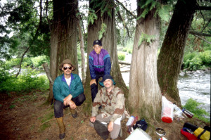 After we ate, Drew filtered water, Larry pondered the map, Steve snoozed in the crotch of a white cedar, and I worked on the log.
After lunch, we launched the Penobscot first so that I could filter some water. (I had used up my supply at lunch.) The Tripper soon joined us, and we continued to Portage #14, a 270 meter trail on the left around steep, rocky rapids. At this point we were still trying to catch up to our schedule; so we didn't spend much time trying to determine whether the rapids were runnable. We simply portaged.
The next rapids, however, looked promising. Portage #15 had a 35 meter trail on the right not far from the riverbank. From the trailhead the rapids looked OK; so we decided to portage some of the gear, then scout the rapids on return. Down near the end of the rapids we spotted a hazard that was not evident from upstream. The left side of the rapids was shallow and rocky out to a boulder in the center of the river. Just beyond the boulder and flanking it on the right was a menacing pillow, and just downstream from that was another sizeable boulder. There was enough room between the pillow and the downstream boulder for the canoes to get through; but passage would require a hard left just past the pillow. Such a maneuver in very swift current would leave no margin for error. Both the pillow and the downstream boulder could easily devastate the canoes. We decided not to take the chance and finished the portage by two-man- carrying the canoes.
Just downstream was Portage #16, with a 45 meter trail on the right. The rapids here were steep, rocky, and obviously not runnable. As we portaged, the sun came out briefly, making the air feel even warmer and more humid. There wasn't much air movement here, but surprisingly there were few bugs. Even so, we were glad to get back out on the river, where there was at least a hint of a cooling breeze. We now expected the river to widen gradually until it became Schewabik Lake.
About a mile downstream we spotted a large cow moose on the right bank. Steve whipped out his camera with a telephoto lens, but the camera jammed as he tried to take a picture of the moose. The moose quickly retreated through marsh grass and muck to the woods on the right shore, then disappeared into the underbrush.
As we continued north, the overcast thickened and the air became somewhat misty. The southerly breeze grew stronger, but because it was behind us, it provided little relief from the warm humid conditions. It did guarantee that we would not be bothered by bugs, though; so after a while I removed my shirt, which by this time was damp and smelly from perspiration. This exposure to the breeze was quite exhilarating, and I began to feel like paddling several more hours.
But the time now was about 5:00, and we had to start looking for a campsite. The map promised a campsite on the right shore about a third of the way up the lake, but we were concerned about the possible encroachments of civilization. This lake was large enough to draw fishermen -- even though they would have to be flown in -- and there was a chance we'd encounter cabins, motorboats, and other such eyesores. In fact, we began to see an odd patch of brightness to the north that suggested some kind of beacon. We hoped it was just the sheen of a smooth rock surface, but as we drew closer, we saw that it was the tin roof of a cabin. The cabin happened to be just north of the campsite we had targeted and well within sight of it. We decided to continue up the lake in hopes of finding a more isolated campsite.
There was supposed to be another campsite on the left shore about two miles farther north. But here too we spotted a cabin on the right shore that we thought would be clearly visible from the campsite. It was late enough, though, that we couldn't afford to go farther. On the right shore we investigated a small, sandy spit that looked as if it might front a campsite that limited the view of the cabin; but the site proved to be too small for two tents. On the opposite shore was a larger sandy spit. Paddling into a stiff wind, we crossed to that side of the lake and found extensive evidence of fishing activities, including numerous pike skeletons scattered across the sand. The campsite turned out to be back on the edge of the woods and faced south, away from the cabin. It featured a fire ring surrounded by sitting logs, crude tables for food preparation, and a cleared space for two tents. But tent sites were strewn with moose and bear scat; so we decided to locate the tents out on the beach.
Pitching the tents in this more exposed location proved to be a real challenge, for the southerly breeze had picked up to the point that it threatened to blow the tents back into the underbrush. Larry's tent, with its aerodynamic contours, was less at risk than mine, with its straight sides. But Steve partially solved the problem with our tent by weighing the tent floor down with rocks in each of its four corners. Despite the tent problems, we were pleased with the wind because it swept the campsite free of bugs. 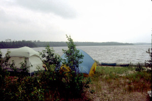 After setting up camp, in fact, we decided to take advantage of the bug-free conditions and go swimming. In this breeze, the air felt much cooler now, but the water was warm enough to make the swim quite enjoyable. As we swam, bathed, and did "laundry", we could hear a loon out in the lake expressing its surprise at the spectacle of four half-naked campers cavorting in the waves. Fortunately the loon was our only spectator. But later we did see a motorboat well to the south.
After the swim it was time to start thinking about dinner. Drew wanted a campfire and started to chop at some dead tree limbs to get firewood. It would have been nice at last to prepare a meal over a campfire instead of using the stoves, but this campsite was easily visible from a great distance down the lake, and a campfire would have shone like a beacon. We were far from Chapleau by now, but not beyond the reach of the MNR; and as far as we knew, the $1,000 fine still applied. As if to confirm our fears, the MNR party of three suddenly appeared as I was trying to collect dinner water out at the end of the spit. (We had decided just to iodize the water instead of filtering it, but along the shore there was too much debris in the water to make it usable. Larry and I eventually had to go out in the Tripper to fill the canteens, water bottles, and cooking pots.) By the time I returned to the campsite, the MNR party had disappeared, and we assumed that they had continued up the lake in search of a decent campsite. Later we discovered that they had made camp right across the lake in the spot we had considered earlier.
This particular dinner was a real crowd-pleaser: Beef Stroganoff, Green Beans Almondine, and Peaches'n'Cream Pie. It was all the more pleasing because the breeze continued to keep away the bugs while we ate. All the while, though, we were threatened by rain. Several times we were exposed to a dank misting, but nothing more substantial came of it.
After dinner, as we attempted to hoist the food packs up out of the potential reach of bears, the wind began to die down, and suddenly we were besieged by hoards of mosquitoes. As soon as the packs were secure, we retreated into my tent to play cards. We lighted some coils of PIC to neutralize the bugs that had gotten into the tent, then played a couple of hands of Hearts. But everyone was tired; so we soon broke up. Larry and Drew made a mad dash for their tent while Steve and I scrambled frantically to close up the entrance to our tent with its increasingly erratic zipper. So many mosquitoes entered the tent during this struggle that we decided to continue burning the PIC as we settled down to sleep. The smoke and smell were quite irritating, though, and made it difficult to fall asleep.
At one point during the night we heard a loud galloping sound -- apparently a moose visiting the campsite in the darkness. The moose stayed around for 5-10 minutes, then departed. At about 3:00AM a light rain began to fall, leaving the walls of the tents thoroughly soaked.
Thursday, June 29
Last encounter with the MNR canoeists; heavy rain; severe slippery trail around rapids and falls; bald eagle; mucky access to 90 meter portage trail; lunch afloat out of reach of black flies; island portage and a rock problem; portage around impassable rapids and falls; black fly problems; camp on a rocky rise; a cool swim; dinner with the flies; fun with fire.
In the morning we fell back into our habit of sleeping in late and didn't rouse ourselves until after 9:00. The weather was overcast, misty, and cool. Hoards of mosquitoes rested on the back window of our tent taking shelter from a moderate southerly breeze. When we exited the tents, we left them open and tilted them up in hopes they would dry out while we ate breakfast. After a light breakfast, we each in succession wandered down the beach and just into the woods to take what was becoming our "traditional" morning constitutional. Meanwhile we gradually broke camp, and by 11:00 we were ready to launch.
Out in the lake we were surprised to encounter the guy from the MNR, who who appeared to be exercising and enjoying a morning's paddle by himself. He informed us that his party had camped right across the lake in the spot we had rejected the previous afternoon. Apparently they had bushwhacked a spot for their tent and had spent a relatively uncomfortable night there. Since his party had intended to go only as far as Schewabik Lake, we knew we wouldn't see them again; so we said good-bye.
Shortly afterwards, as we headed up the lake, we noticed that the mist behind us was thickening rather rapidly. 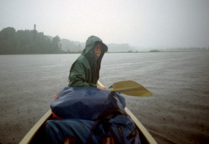 By now the air had warmed enough to make any waterproof apparel feel uncomfortable; so it was with some reluctance that we prepared to don our raingear. The rain arrived at around 11:30 and became heavy at times. Eventually the rain subsided as we approached the northern end of the lake around 12:30.
The lake gradually narrowed to river width and then suddenly funneled through a sluice with steep rocky shores on both sides. The river here dropped a total of almost 8 meters through a series of rapids and falls. Portage #17, a 125 meter trail on the right, proved to be one of the most difficult we had encountered on any of our trips. There was no real landing for the canoes -- only a jumble of large, angular boulders with very few footholds. From there the trail ascended an almost impossibly steep slope made treacherously slippery by the earlier rain. Unloading the canoes was hard enough, but getting the canoes out of the water and up the slope was a truly formidable undertaking. There was no way anyone could portage a canoe in the usual fashion; so we resorted to a 2-man drag/carry that seemed more like rock-climbing with a sled than portaging with a canoe. About 40 meters up the slope, the trail leveled off somewhat. 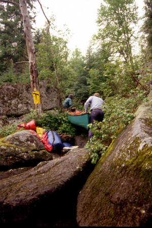 From there Larry and I carried our respective canoes over the crest of the hill and down another steep and slippery slope to a rocky landing almost as bad as at the start. As I descended with the Penobscot, the stern line came loose, dropped to the ground, and became entangled in the underbrush along the trail. For a moment the entangled line acted like an anchor until my persistent tugging, along with the downhill force of gravity, separated it from the canoe. Later I had to go back and unravel the line from the underbrush.
After the portage, we canoed up near the falls to take photos, then paused to snack and filter water. Once under way again, we spotted a bald eagle soaring above the river ahead. It soon passed over treetops on the right shore and disappeared from view.
About a half hour later we reached Portage #18, a 90 meter trail on the right around what were described as "impassible rapids". What we could see of the rapids looked very rocky; so we decided to portage. But getting to the portage trail was somewhat of a challenge. The landing was quite mucky and surrounded by rocks. It appeared that normally the canoes would float right over this mess to firm, grassy ground about 5 meters in; but lower water levels had exposed the rocks and muck, forcing us to 2-man carry the canoes through the sucking black mud. Once we were on the trail, though, the portage turned out to be relatively easy. The only real problem was the steady increase in black flies as we reloaded the canoes.
Upon launch, we paddled as quickly as we could out to the center of the river where we hoped the moderate breeze would give us some relief from the little pests. There we paused to filter water and eat lunch. The clouds were dissipating now, but the humidity remained, and the sun made us feel uncomfortably warm. While we ate, we drifted most of the way to the next rapids.
These rapids presented an interesting challenge. They flowed around both sides of a small, tear-shaped island. A 125 meter portage trail (Portage #19) began more-or-less on the middle bank of the island, passed along the island's right edge, and ended just to the left of the tear's upper point. The trail was rather pretty and lined with bunchberry. At the end of the trail we had to launch into the last 45 meters of the rapids. The rapids looked easily runnable, but there was a large rock on the left side that we needed to avoid. The problem was that the current coming around the right side of the island tended to push us right toward the rock. To avoid the rock, it was important to get the canoe pointed in the right direction, but the swift current made it difficult to position the bow for launch. Larry and Drew struggled for a while to get the right launch angle, but once underway they had no problem avoiding the rock. 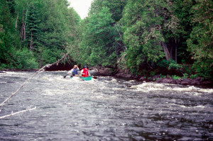 Steve and I had less trouble getting the right angle, but we still managed to come dangerously close to the rock.
Just around the bend from these rapids was Portage #20, a 125 meter trail on the right around what were described as "several impassible rapids and falls." The trail cut across a severe bend in the river; so we couldn't actually see what made the rapids impassible. But the trail itself was almost impassible at one point -- blocked by a fallen pine that was flanked by other trees in such a way that it was extremely difficult to maneuver the canoes around the blockage. Near the end, the trail suddenly dipped, and a covering of pine straw made the footing rather slippery. For some reason the black flies were especially bad here, and we seemed to be unable to shake them even after we launched out into the open river. For a while we paddled furiously in efforts to find a steady breeze that would blow the little buggers away. Eventually we reached a broad stretch of river just past a small reedy island. Here we were well away from any trees; and what little breeze there was gave us some relief from the flies.
Curiously, this ordeal with the black flies had not affected Drew, who seemed impervious (or maybe oblivious) to the little buggers. By the end of the trip we would find ourselves wondering if we shouldn't patent his blood and sell it as black fly repellant.
The morning clouds were pretty much gone now, and the sun was driving the temperature up into the 80's. The air still felt humid, and we longed for a stronger, steadier breeze. As we continued north, we noticed that the terrain was mostly marshy along the banks, but the land just above the banks seemed to alternate between stands of black spruce, jack pine, and white cedar and stands of alder and white birch.
At about 5:00 we began to talk about camping alternatives. Our target for the day was an established campsite at Portage #22 -- still five miles and two portages away. Since it was getting late, we decided to give serious consideration to any promising-looking campsite we might encounter along the way to Portage #22. At about 5:30 we came upon an oxbow lake that extended off to the left. On the right bank was a rocky rise leading up to a picnic table -- which of course suggested a potential campsite. We paused to investigate, docking in the shade of a large white cedar just past the rocky rise. Just above the rise, the site leveled off into an open, grassy area dotted with wild daisies, orange hawkweed, and buttercups. This area appeared to have been cleared back to the trees, which together with the underbrush formed an almost impenetrable thicket around the site. On the whole, the site seemed suitable for camping, but we were all rather ambivalent about making camp here.
On the positive side:
. Level space for two tents
. Good access to water
. Good place to swim
. Picnic table for food preparation
. If we stopped now, we'd have plenty of time to set up camp and relax.
On the negative side:
. Swarms of black flies (which would make it hard to relax)
. No trees in the campsite -- no shade, and no place to put drying lines
. Litter: ugly broken platforms (formerly used as tent bases?), rusty shopping cart in a nearby ravine, other junk lying around
. If we stopped now, we'd be behind schedule.
We decided to stay -- mostly because we were warm and uncomfortable and were looking forward to the prospect of swimming to escape the heat. Because we would now be well behind schedule, though, we vowed to break camp early the next morning.
As we were setting up camp, a large beaver swam by out in the river. It paused for a moment to survey our activities, then dove beneath the water with a loud slap of its tail. We didn't notice any beaver lodges nearby; so we assumed the beaver must live over in the oxbow lake just across the river. We didn't see the beaver again.
Once camp was set up, we all went swimming. By this time the sky was nearly cloudless, the breeze was waning, and the campsite, which faced the afternoon sun without benefit of any shade trees, was becoming very warm. By contrast, the water was cool and refreshing. The rock bank was slippery but relatively smooth, and we were able to enter the river rather easily, without having to worry about the usual sharp rocks. Only a few meters out, though, the bottom dropped off very suddenly to at least 7 meters depth. 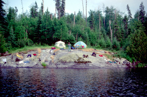 At one point I tried diving to the bottom, but the cold and pressure prevented me from reaching it. As long as we were out in the water, we were free of the black flies that plagued the campsite, but here we encountered a new nemesis: larger flies (of the horse-, deer-, or sand- variety) that kept dive-bombing our heads. We swam for quite a while, but eventually the cool water began to give us the chills. Then it became a mad scramble to get out of the water, dry off, and dress before the bugs discovered the meal. Since there was no place to hang a line, we had to spread our wet clothes out on the rocky slope to dry them.
The sky was clouding up again, but the breeze had died completely, and the black flies seemed to become more voracious than ever. It was time to start the dinner. Larry put Drew in charge of dinner tonight, and Drew set about preparing the main course, Chicken a la King, with a side dish of peas and carrots. I broke out my Whisper Light stove for the first time so that I could prepare the dessert: apple cobbler. Drew and I both ran into some trouble. Drew spilled the veggies while pouring hot water into their pouch, and he had a problem getting the main course back into its insulating pouch after he had added the hot water. Meanwhile, I was having trouble interpreting the apple cobbler instructions, which called for high-medium-low heat modulations that were beyond my stove's capabilities. Even so, dinner came out pretty well, and the Chicken a la King turned out to be the best-tasting main course yet.
When dinner was ready, we tried again to use Larry's net tent to provide shelter from the relentless black flies. But once again we were defeated by the cramped conditions and by the virtual impossibility of getting us all under the tent without also getting hoards of bugs under the tent at the same time. Finally we had to resort to the usual dinnertime strategy: eating while "walking around". But with the flies swarming this badly, no strategy worked very well. I ended up with more fly bites during a couple hours at this campsite than during the previous four days of the trip.
After dinner, Drew and Steve started a fire. Unfortunately the fire was too close to the edge of the rock surface, where it gave way to grass and wildflowers. The grass here was brown and dry -- apparently scorched from the sun's heat reflecting off the rock face. We had to douse it thoroughly with water to keep it from catching fire. Meanwhile, Drew kept tossing hunks of wood on the flame until it became a raging bonfire in the waning light. He also tossed in a few oxygen absorber packets from the freeze dried food pouches and enjoyed the pyrotechnic effects that ensued. We hoped the fire would chase away the bugs, but no such luck. As darkness fell, we began to hear the familiar and ominous "mass whine" of the mosquito community as it prepared for its evening meal. It was time to retire to the tents. With some disappointment, we drowned the campfire and prepared to go to bed. Since there were no trees in the campsite, we couldn't do much about bear-proofing the food supplies; so we just put the food packs out in the canoes, which were tethered to the large white cedar where we had landed.
We had PICed the tents before dinner; so they were relatively bug-free when we entered them. But apparently the PIC just narcotized the bugs, causing them to drop to the floor in a stupor. Later, after we opened the windows to let in fresh air, the bugs would revive and have their blood feast while we were sleeping. I made it that much easier for them to feast tonight because I again started the evening without my sleeping bag in order to get relief from the heat and humidity. Once again, though, the air cooled off enough by 2:00AM that I was forced to use the sleeping bag as a quilt.
Shortly after I resorted to my sleeping bag, I heard a loud "kerplop" outside the tent. I asked Steve if he heard it, and then we both pointed our flashlights out the front door and out into the river. We couldn't see anything, and we didn't hear anything more; so we settled back down. About ten minutes later I heard the noise again moving away from us. Evidently it was a moose on the other side of the river wading in the reeds along a kind of peninsula that separated the river from the oxbow lake.
Friday, June 30
Morning moose; running shallow rapids at portage #21; clearcut logging; another portage; drifting lunch; beaver lodges and hunter's camp; running the rapids at portage #23; maneuvering through the rapids at portage #24 and a temporarily lost paddle; more rapids; difficult scouting at portage #26; missed portage and resultant difficulties in the rapids and rocks; rainy campsite at portage #27; moose and calf sighting; shelter and dinner preparations; smoky campfire.
I awoke in the morning at around 7:00 and worked on the log for a while. The sky was mostly clear, with just a few high clouds, and the air was already starting to warm. A loon called not far away, probably from the oxbow lake. Back behind the tents, the woods echoed with the staccato sound of woodpeckers, almost like native drummers trying to communicate with each other.
We exited the tents around 8:00. While preparing breakfast, we spotted a moose wading along the shore upstream from the camp. We assumed it was the moose we had heard in the dark. Evidently we were in its "territory".
After breakfast we started the process of breaking camp and managed to be ready for launch by 9:45, our earliest departure yet. By this time it was already warm and humid, with very little breeze, and the bugs were already becoming bothersome. Such oppressive weather conditions were very unusual for this part of Canada, and we were glad to get out on the water, where the air seemed just a bit cooler.
Within a mile or so we came to Portage #21, a 110 meter trail on the right. After briefly scouting the rapids, Larry and Drew decided to run them fully loaded in the Tripper. The water looked rather shallow to me, and the Penobscot tended to ride lower than the Tripper. Steve and I decided to portage our gear, then run the rapids without a load.
The river proceeded through the rapids in a broad backwards "S". The plan was to enter the rapids in midstream to avoid a strainer and a ledge on the left and a large pillow on the right. Once past the pillow, we would steer toward the right, then ride the deeper water near the right bank as it curved back toward the left. We wanted to avoid a large rock in the center just past the pillow and a jumble of rocks farther downstream on the left.  However, when Larry and Drew launched into the rapids, they deviated from the plan by veering right too soon, which necessitated a sharp turn around a boulder to the left and then another turn to the right. They then paddled furiously back over toward the right bank to get back into the deeper water. Larry seemed pleased that they had been able to maneuver so effectively despite the misdirection. Steve and I were concerned that these wild maneuvers might indicate an unforeseen hazard. But since we couldn't hope to follow their crazy path, we went ahead with the original plan and, much to our relief, made it through the rapids without incident.
Just past the rapids we paused for a while to filter water and snack on trail mix. Once under way again, we encountered direct evidence of the massive logging we had suspected all along -- a clearcut area along the right bank that served as a window into more extensive clearcut extending well back behind the trees lining the river. Once again we were observing a phenomenon we had observed on the Mississagi and Missinaibi trips: a facade of trees along the river apparently left to give the impression of wilderness when, in fact, the whole surrounding area had been extensively logged over. As in the past, this phenomenon saddened and angered us, but it did not surprise us.
By now the sun was out in full force, and the air was almost unbearably warm. From time to time we were relieved by clouds passing in front of the sun, but never for very long. After a half hour of paddling, we came to Portage #22, a 180 meter trail on the right around steep rapids ending in falls on the right. A convenient landing fed into an easy trail, which passed through a meager campsite near the end and terminated in an equally convenient launch.
We reloaded and launched the canoes as quickly as we could because the mosquitoes here were especially bad. Then we paddled out to a widening of the river and paused for lunch. The time was now about 12:30. After strapping the canoes together, we passed around smoked gouda cheese and summer sausage. Meanwhile I filtered water to fill my canteen. Gradually we drifted over near the right bank. Normally we would have been concerned about bugs near shore, but in these warm conditions, we welcomed the shade from the trees along the bank. However, Drew seemed anxious to keep moving; so he laboriously paddled the lashed-together canoes back out into the current and, to our chagrin, back out into the hot sun. This maneuver quickly brought our lunch to an end. We would rather be paddling than just drifting and baking in the hot sun.
It was 6 miles to the next portage. This stretch of the river was relatively straight and passed through terrain that could be described as "typical": Reeds along the shore, white cedar and/or black spruce lining the bank, with white birch farther back. Every half mile we encountered a beaver lodge. The lodges varied in size, shape, and sophistication (at least on a scale of beaver competence), but we found it interesting that they were so evenly spaced apart -- as if the beavers had a finely honed sense of territoriality.
We stopped once along this stretch for a water and snack break, and at one point we spotted a hunter's camp on the right shore. The camp featured a large rough-hewn wooden rack presumably used for bleeding and drying animal carcasses. Steve and Drew noticed a canoe resting on the ground in the underbrush. There was no sign of a tent, though. We speculated that an outfitter might be storing the canoe here for use by flown-in hunter clients.
Eventually we came to a stretch where the banks grew rocky and the river narrowed to rapids. The brochure said the rapids could be run "with difficulty"; otherwise we could take the 180 meter portage trail on the right (Portage #23). We paused on the right bank to scout the rapids, but they looked straightforward and easily runnable; so we launched right into the rapids, staying in the substantial waves on the right side. The canoes took a bit of water, but otherwise the run was as easy as it looked.
These rapids were the first in a series of six over a 3-kilometer stretch of the river; so it wasn't long before we reached the second rapids. Portage #24 extended 150 meters on the right, but the brochure said the rapids here could be run "in low water" -- a rather curious assertion, since low water usually exposed rocks and shallows that tended to make rapids unrunnable. We steered the canoes over to the right bank and then waited while Larry scouted the rapids. After a considerable time, he returned with a strategy. The river curved to the right, then back to the left. We could run the upper portion of the rapids on the left side, where large waves indicated plenty of water, but we would have to stay just to the right of the waves to avoid getting swamped. The current would then take us across the river directly into an eddy on the right side at the point where the river began curving back to the left. Larry proposed to pause in that eddy and scout the lower portion of the rapids. To begin the run, though, we would have to ferry over to the left side of the river.
Larry and Drew went first and were waiting for us in the eddy when we came charging across the river and slammed into a shallow, rocky area just below the eddy. Steve and I pulled the canoe into the bank; then Larry and I hobbled downstream through the jumbles of rocks along shore to scout the lower rapids. The lower rapids looked easily runnable, with big waves on the right side. After we made our way back to the canoes, Larry and Drew launched out of the eddy, pulled upstream a few meters, then peeled out into the current and continued through the remaining rapids.
Steve and I were all ready to do the same when I discovered that my paddle was missing. After casting about for it in vain, we concluded that it must have slipped into the water and washed downstream. Since there was no spare paddle in the Penobscot, and there was no obvious way to portage or line the canoe from this point, our only hope for finishing the rapids was to borrow the spare paddle from the Tripper. I hobbled back downstream along the bank, picking my way through the jumble of rounded, slippery rocks until I was within sight of Larry and Drew. I signaled to them that I had lost my paddle and needed a spare. Larry motioned for me to continue downstream around a bend and meet them in a marshy area below the rapids. As I stumbled through rocks and watery potholes toward the meeting spot, I noticed the glint of something shiny in the river well past the rapids. I shouted for Larry and Drew to check it out, and to our pleasant surprise it turned out to be my aluminum-stemmed paddle. While they retrieved the paddle and then canoed back upstream, I waded out to a small, reed covered island where they could easily dock. With the paddle to use as a kind of walking stick, I found it somewhat easier to make my way back upstream to the eddy where Steve was waiting. Then at last we launched out of the eddy and completed the rapids without further incident.
Within a few minutes we encountered the next set of rapids. We didn't see any portage signs in the area, although there were a couple of spots that suggested portage landings. The rapids looked easily runnable, with just a few shallow rocky areas to be avoided on the flanks; so we ran straight through the center. The rapids were broken by a short stretch of calmer water; so we concluded that we were passing both Portage #25 and Portage #26. This conclusion would prove to be erroneous -- with nearly disastrous consequences!
When we reached what we thought was Portage #27, we were faced with about 10 meters of rocky shallows to get to the portage landing. The water here was so shallow that, in order to float the canoes to the landing, we would have to unload the canoes and carry the packs to shore through the muck. We quickly decided to run the rapids if we possibly could. Larry and I scouted the rapids by walking among the slippery rocks along the bank almost to the end. At one point I lost sight of Larry in a tangle of white cedars and underbrush that made further progress very difficult. I decided to bushwhack over to the portage trail. I hiked to the end of the trail, where there was supposed to be an established campsite (according to the brochure), but I saw no campsite (because, of course, this was really Portage #26, not Portage #27). Then I worked my way back upstream on slippery logs piled up along the bank in zigzag patterns. Eventually I met Larry, who was still working his way downstream. We both thought the rapids looked runnable -- as long as we stayed on the right side in the big waves.  Returning to the canoes, we launched and made the run with little trouble -- just taking in a bit of water from the big waves.
Steve and I completed the run first and continued downstream, expecting not to see any more rapids for at least a half hour. When we encountered some swift water, we thought it was just riffles. We certainly didn't see any portage signs that would indicate a need for caution. But as we rounded a rightward bend in the river, we realized we had entered a major set of rapids with a profusion of rocky hazards. Quickly scanning the river for a safe haven, we spotted an eddy near the left shore where the river started another rightward bend. We headed straight for the eddy, but plowed into some submerged rocks just in front of the eddy. The current swung us around, almost turned us over, and then pinned us sideways against some more rocks just downstream. Initially it appeared the only way to escape from these rocks was to use the paddles to push away from them, but the angle was such that we would end up going downstream backwards. Finally I realized I would have to get out on the rocks and manhandle the canoe into the eddy. That's what I was doing when Larry and Drew arrived in the Tripper. Seeing our predicament, they pulled into the eddy farther upstream, thereby avoiding the submerged rocks that had caused us such grief.
From the eddy we paused to survey the situation. We still had at least three-quarters of the rapids to run. There was no evidence of a portage trail. There was no room to walk along the left bank, nor any walkable rocks from which to line the canoes. From this side of the river we could see no obvious safe route to paddle through the remaining rapids. It appeared our only recourse was to get to the other side of the river and hope we could spot some opportunities from there. Larry and Drew pulled out of the eddy, then ferried over to the other side of the river paddling upstream against the current. On that side Larry was able to walk downstream far enough to get a better look at the rapids. When he returned to the Tripper, he motioned for us to ferry over to that side so we could talk (the rapids were too loud for us to hear each other across the river). Steve and I made a couple of ferry attempts, but the bow kept getting hung up on rocky shallows just upstream of the eddy, spoiling the angle we needed to maintain for the ferry. Finally we tried exiting the eddy farther downstream. This strategy put us in a more precarious position, forcing us to paddle harder against the current to avoid being swept backwards into downstream rocks; but it succeeded.
When we reached the other side of the river, Larry revealed the results of his scouting. There was plenty of water on the left side past the rocky area where we had been hung up, but the large waves would have to be avoided. If we stayed just to the right of the waves, we could make it well down the rapids to a shallow area from which we could probably walk the canoes for a way. The only real hazard was a large rock just before the shallows. With this information, Steve and I paddled upstream a bit, peeled out, steered over toward the left bank, then followed the big water downstream, passing just to the left of the big rock into a distinct V which emptied into the shallows. But the shallows turned out to be a bed of submerged rocks. We crashed into one of them, then got pinned sideways against the others.
While we struggled to free the canoe, we heard a rumble of thunder. Dark clouds were rapidly approaching from the southwest, and it looked as if we would be caught in a thunderstorm right out in the open. By the time Larry and Drew arrived, we had freed the Penobscot and were walking it through the shallows toward the left bank. From there we walked both canoes across the mouth of a stream that entered the river from the left. At some points along this "walk" we were close to swimming, since the water was above our waists. Then we paused at a ledge that appeared to extend all the way across the river. There was a small break in the ledge on the left side, and from there big water flowed along the left bank, curving around to the right to the end of the rapids. We launched the canoes through the break, then bucked our way through wild waves to the end, dodging rocks and taking plenty of water during the ride. Larry and Drew became hung up on some rocks in the last chute (which Steve and I somehow managed to avoid), but they managed to extricate themselves without mishap.
Now that we were at last beyond the rapids, we paddled over to the right shore to look at the campsite at the end of what was evidently Portage #27. The campsite was not appealing. A mucky landing led to a cramped, breezeless site that promised to be buggy. On the other hand, the campsite did have two tent sites, a bench for seating and food preparation, and a promising area for latrine not far away; and unlike its predecessor, this campsite was nicely shaded by large white cedars. On the aesthetic side, there were several striking clumps of wood lilies, with their orange trumpets and maroon-speckled throats.
Our options were pretty limited at this point. It was already 5:30. Increasingly loud peals of thunder indicated the storm was only moments away now. We would have to wait here until the storm passed -- possibly as long as an hour. The next documented campsite was about 4 miles away, which would mean setting up camp as late as 7:30. But if we did continue to that site, we would be only 6 miles from Elsas, the end of our trip. That would make our last day's canoeing too short. We quickly came to the conclusion that we would have to camp here.
Once the decision was made, we scrambled to set up camp before the storm broke. First priority was setting up the tents, which we did in record time. But the storm broke before we could get our sleeping gear into the tents. Larry threw a tarp over much of the gear, but my thermorest mattress and sleeping bag didn't make it under the tarp in time and got wet. None of us had time to get into our raingear; so we waited under the trees and were eventually soaked to the skin.
After about 20 minutes, the rain tapered off somewhat. Larry and Drew climbed into their tent to change into dry clothing and raingear.  I decided to take care of an insistent "call of the wild". Grabbing the port-o-john seat, I trotted down the trail and found a surprisingly bug-free spot for latrine. When I returned, Larry and Drew were still in the tent, and Steve was still standing under the dripping trees. I climbed out on a couple of cedar strainers overhanging the water to get a better look at the southwestern skies. There I stood for a while, transfixed by a misty view of the rapids we had just run. Steve interrupted my reverie by pointing out a moose and calf that had just arrived on the opposite shore just downstream. We alerted Larry and Drew, but they never made it out of the tent. Steve managed to get a regular photo of the animals, but by the time he had his telephoto lens in place, they were retreating back into the woods.
The rain continued. I decided to hike up the 315 meter portage trail to determine why we hadn't seen any sign of a portage when we approached the rapids. The trail was pretty, with bunchberry blossoms lining it much of the way, and the terrain was easy, with no moosemuck, steep hills, or jumbles of rocks to overcome. Trees had fallen diagonally across the trail in a couple of spots, but someone had cut them into sections. Still, I had to maneuver around them, which was somewhat difficult because the trail was quite overgrown, apparently from lack of use. Evidently other canoeists had missed the trail, too, and I discovered why when I reached the head of the trail. The portage "sign" was merely a tiny yellow marker nailed to the trunk of a tree. To spot this marker, you would have to know exactly where to look; and you would look for the marker only if you were expecting a portage.
The rain continued sporadically. As I returned down the trail, the wet overgrowth saturated my clothing, so that I was even wetter than before. When I reached the campsite, Larry and Drew were just emerging from their tent, and Steve was just entering our tent to change into dry clothing. Since the rain showed no signs of stopping completely, Larry and I decided to put up a tarp over the fire/kitchen area.  We struggled with that task for a while as we tried to find angles to tie the tarp so that it would be high enough for us to move around under, yet spread out and slanted properly to shed rainwater. Eventually we worked out an adequate arrangement, and Larry began to prepare for dinner. The air seemed to be getting cooler in the wake of the thunderstorm; and I started to feel a bit chilly from being so wet; so I decided to follow the crowd and change into dry clothing. At about this time, Steve woke up from an impromptu nap and emerged from the tent, allowing me plenty of room to change. In the tent I donned dry clothes and a rain jacket, sprayed my feet with bug dope, then emerged wearing sandals. It felt great to be free of my wetshoes, which had been saturated for hours.
Dinner consisted of Chili Mac, corn, and cheesecake -- all excellent, especially the cheesecake, which Steve prepared in order to redeem himself from a cheesecake fiasco of several days earlier. After dinner, Drew and I went out in the Tripper to filter water while Larry and Steve washed dishes. My filter was badly in need of cleaning; so it took almost 45 minutes to fill my canteen. Meanwhile, Drew managed to fill two water bottles and a water pouch with Larry's filter.
When we returned to shore, Drew started a campfire. He had to use firestarter paste to get the damp wood burning. Then we all sat under the tarp watching the fire and choking on the (probably toxic) smoke from burning plastic food pouches. Drew threw several packets of "oxygen absorber" (a preservative in the food pouches) into the fire, which produced sparkler-like effects that made it seem as if we were celebrating Independence Day a few days early.
Eventually it was time to think about bear-proofing the food. Since we were only a few hours away from Elsas at this point, we weren't too concerned about losing our supplies to a hungry bear. It was too dark anyway to look for a good "hanging tree"; and the battery had just died on my spotlight. We decided just to put the food packs along the trail away from the camp.
By the time we turned in, the rain had stopped. The air was humid, but comfortably cool for a change. With the fatigue of a hard day in our bodies and the rush of nearby water in our ears, we fell asleep quickly and slept pretty well.
Saturday, July 1
Cool and damp; running rapids and portaging; "dumb duck" syndrome; running and lining at portage #30; paddling in strong winds on Kapuskasing Lake; sheltered campsite on a small island; camp set up and dinner in the cold, rain, and wind.
In the morning the sky was still overcast, and everything was still wet. The temperature was more typical of Canada: about 55. We all awoke just before 9:00 and had our usual breakfasts of hot and cold cereal washed down with camp coffee that seemed especially welcome in these cool, damp conditions. It took us a while to break camp because everything was so wet, but we were able to depart by around 11:00.
Just downstream from camp, the river narrowed and began winding through a series of riffles. After yesterday afternoon's experience of riffles turning into major rapids, we were just a little apprehensive about this. But the river soon settled into the usual bends and curves. A northwesterly breeze had sprung up; so at times we would curve into the wind and at other times away from it. At one point the overcast grew brighter, as if the sun were about to emerge, but then the overcast thickened, and a steady misting rain developed. Everyone paddled in his raingear -- more to keep warm than dry.
After a while, the river suddenly narrowed again. Portage #28 passed 270 meters around the right of the rapids here, but the brochure suggested that we could run the first part of the rapids and cut about 130 meters from the portage. We followed the suggestion, running the initial rapids just right of center, then portaged the remaining 140 meters. The lower rapids curved around a rightward bend, and from the end of the portage trail we could see some huge waves and a formidable sousehole.
Only half a kilometer away we could see Portage #29, a 225 meter trail on the right. When we reached it, we portaged the gear, then scouted the rapids to see whether we might be able to run them in empty canoes. 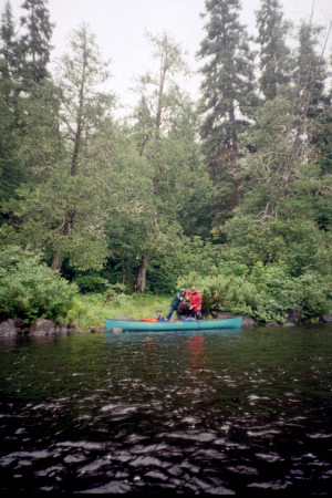 But large waves, nasty rocks, and wicked souseholes made the run look extremely hazardous. We went ahead and finished the portage.
We were now on the final leg of the Chapleau River. At around 1:30 we paused for snacks, but the snacks were interrupted when the canoes drifted into swift water. We paddled through the swift water, then finished our snacks. Soon after we resumed our northward course, we observed a case of what came to be known as the "dumb duck" syndrome. On previous trips, and earlier in this trip, we had observed mother ducks acting lame in order to lure us away from their ducklings. They would send their ducklings over into the reeds while they flopped around lamely out in the middle of the river trying to lead us away. As soon as we were far enough away, the mother would suddenly recover, take off out of the water, and fly back to the ducklings. Now we encountered a Merganser who didn't seem to know how to execute this maneuver. She acted lame, but didn't move away from her ducklings; in fact, she led them right across our bow, so that we almost ran over them. We speculated that this mother duck might be subject to prosecution by the MNR for negligent duckling abuse!
At around 2:30 we approached the end of our river trip. Portage #30 would take us 210 meters on the left around two sets of rapids into Kapuskasing Lake. As we approached the portage, we noticed that the northwesterly breeze had turned into a stiff wind. We were concerned about the impact this wind would have on our impending lake travel, but at the moment we had to concentrate on getting to the lake. We could not find the portage trail. There were no signs, and there was no evidence of a portage landing. The first set of rapids looked relatively innocuous; so we decided to run them and see whether the trail might start just before the second rapids. But once we reached the second rapids, we still could not locate the portage trail. These rapids were not runnable, but rocky shallows on the left side suggested the possibility of lining the canoes through the rapids. The lining operation went rather smoothly for both canoes, and we eventually pulled them to a spot from which we could run the remaining rapids.
We were now on an arm of Kapuskasing Lake. We paused briefly for snacks, then proceeded toward the body of the lake. Almost immediately we encountered a fishing camp on the right shore and a motorboat out in the water just beyond. Our "wilderness experience" was pretty much at an end.
As we continued out into the lake, we felt the growing force of the northwesterly wind, which whipped up ferocious waves that crashed into the sides of the canoes. The waves bounced the Tripper up and down like a bucking bronco, and with its high profile, the Tripper caught the wind almost like a sail, making it especially hard to steer. The lower profile of the Penobscot put it less at the mercy of the wind, but waves occasionally broke over its gunnels, threatening to swamp us and, in any case, leaving us wet and uncomfortable. To avoid capsizing, we could not paddle directly toward our northeast destination. We had to paddle diagonally into the waves for a while, then quickly come about, then paddle diagonally away from the waves for a while. This zigzag course slowed us down considerably, and steering the canoes to avoid broadsides to the wind was an undertaking both exhilarating and exhausting.
After what seemed like hours struggling through the waves, we spotted a small collection of white buildings on the north shore of the lake. At first we thought these structures might be part of another fishing camp, but when a freight train passed through, we realized we were looking at the town of Elsas. Now we had to reach the island that the outfitters had recommended for our last night's camp. The island was about one kilometer southeast of town, and although it was quite small, we could see it well enough from here. It didn't look very promising. A squall line was approaching across the lake from the west; so we quickly paddled to the north side of the island. The squall broke just as we beached the canoes on the smooth rocky shore. We walked to the east end of the island looking for tent sites that would be reasonably protected from the wind. But this island seemed to be nothing but rocks, marshgrass, and scrubby bushes. We would have to pitch our tents on slanted rock or on top of bushes and tall grass, and the wind would probably blow the tents away while we were trying to set them up. If we did manage to set up a camp, we would have virtually no privacy.
To the west we could see another small island -- with trees! To get to it, we would have to paddle straight into the wind, but under the circumstances we didn't have much choice. Just about anything would be better than this desolate, windswept outcrop. We paddled back out into the waves and struggled over to the other island, then circled it in opposite directions, Larry and Drew paddling clockwise, Steve and I counterclockwise. We met on the west side of the island, then returned to a rocky landing on the south side so that Drew could go up into the "woods" in the center of the island to look for a possible campsite. When Drew returned, he announced that a short trail led into a clearing in the middle of the woods with a nice carpet of clover where we could put the tents. 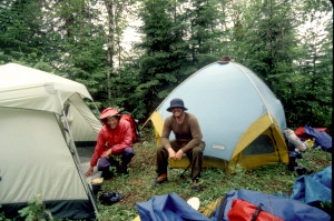 We were intrigued, but somewhat skeptical; so we all decided to take a look. The site turned out to be a dream come true -- at least under these cold, wet, windy conditions. The clearing provided a rather close campsite, but it was big enough for two tents and nicely sheltered from the wind. We decided to stay.
After unloading the gear, we pulled the canoes up into the rocks and tried to situate them out of the wind. Then we began to set up camp. As soon as we had the tents up, we strung clothesline wherever we could find an opening, then hung our stuff out to dry. We left the tents open to air out. For the first time since we had left Chapleau, bugs were not a problem. But even in this protected spot we could still feel the wind blowing, and the air seemed to be getting colder. All of us changed into warmer clothing -- pleased nevertheless that we were finally getting the cool weather we expected in Canada. From time to time we walked the trail back out to the rocks to check the weather conditions across the lake. Several times it appeared that another rain squall was approaching from the west; so we scrambled to close up the tents and take stuff off the lines. But each time it was a false alarm.
After a while, Larry decided to take a Scotch break. He pulled out his Dewar's and invited us to join him. Steve and I accepted the invitation. Meanwhile, Drew went exploring and found a piece of charred driftwood that looked like a dragon skull. He put a string leash on it and began "dragon" it around. 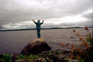 He also found an old "pipe rocket" which he tried unsuccessfully to light.
Eventually we started heating water for dinner. Tonight's dinner turned out to be "fielder's choice": Steve and Larry had spaghetti and green peas, while Drew and I had Pasta Prima Vera and garden vegies. Dessert was a repeat favorite: peaches 'n' cream pie. While we prepared to eat, a squall line approached across the lake from the southwest. We removed our stuff from the lines once again, served ourselves "buffet style", then all hopped into my tent just as the rain started. We finished eating inside the tent.
During dinner we discussed plans for the next day. The train was scheduled to arrive at around 8:00 the next morning. We wanted to make sure we were waiting by the tracks in plenty of time. We figured it would take about a half hour to paddle from the island to Elsas and another twenty minutes to haul the gear and the canoes up next to the tracks. Typically it had taken us at least two hours each morning to break camp; but we thought we could cut that to one hour if we postponed breakfast until we were positioned by the tracks and then just ate up the remaining breakfast bars while waiting for the train. Our target, then, was to get up at 6:00 in the morning.
It was still raining when we finished eating; so we pushed the dishes outside the tent where the rain could rinse them. We decided to finish cleaning them in the morning -- there was no need to worry about animals (even bugs, let alone bears) being attracted to the food residue way out here in the middle of the lake. We talked for a while longer, but by 9:30 we were ready to turn in. After all, we were all pretty tired from the hard paddle across the windy lake; the cool rainy conditions left us little to do around the campsite; and in any case, we knew we'd have to get up early the next morning. Larry and Drew left for their tent as soon as the rain let up a bit.
The rain continued sporadically for another hour, then tapered off. The wind never let up and, in fact, grew stronger at times during the night. The roar of air through the trees and the slapping of waves on the island's rocky shore produced a cacophony that was almost as comforting as it was disturbing. It was comforting to think about how nicely sheltered we were in the middle of this wooded island compared to what might have happened to us if we had camped on the grassy island we had first investigated. Above all this cacophony, though, we could still hear an occasional loon call during the night, and at one point in the early morning a train passed through Elsas with such a pervasive rumbling noise that it seemed right outside our tents!
Sunday, July 2
Early rise and departure; canoeists at Elsas; waiting for the train; refuge in the cook house; the well-educated cook; train ride to Folyette; shuttle back to Chapleau; the trip home.
When I awoke at around 5:30AM, the air was quite chilly, the wind was still blowing, and everything was very wet. The sky was covered with fast-moving clouds, and patches of fog drifted across the lake, but an occasional snatch of blue appeared in this cauldron of grey. I worked on the log for a while, then called out to ask Larry the time. (My watch was broken; so I could only estimate the time.) He answered that it was 5:51 -- almost time to get up.
As planned, we exited the tents at 6:00, skipped breakfast, broke camp in record time, and managed to launch the canoes by 7:00. Loading and launching the canoes was a bit tricky because our launch point was fully exposed to the waves charging in from the west. But once we were under way, the wind and waves pushed us more-or-less toward Elsas, so that we covered this last half-mile of paddling in just a few minutes. 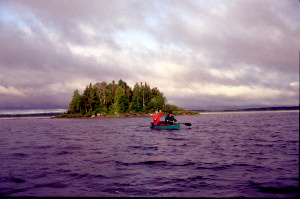 As we approached the long wooden dock at Elsas, we noticed especially dark clouds rushing toward us from the west. We fully expected to get drenched, but surprisingly no rain ever materialized.
While unloading, we were engaged in conversation by an older guy who, oddly enough, just seemed to be hanging around the dock at this early hour. Initially we thought he might be a fisherman getting ready to go out for the day, but it turned out he was with a party of canoeists (8 men, 2 women) from the Sudbury area who were about to embark on a trip up the Kapuskasing River. They had been dropped off by the train the previous evening and had spent the night in tents pitched right behind a utility building next to the railroad tracks. They were now in the process of preparing breakfast, and we found the aroma of bacon almost irresistible as we portaged the canoes and gear past their campsite up to the tracks. We had to console ourselves with the remaining breakfast bars, which we finished off while waiting beside the tracks.
For the next 45 minutes we sat around talking about the trip, watched a small flock of Evening Grosbeaks flitting around a truck parked next to the tracks, and occasionally walked around to keep warm in the chilly wind. At one point several railroad workers came out of a cabin across the tracks and boarded a diesel locomotive, which then departed heading east. Another older guy from the party of canoeists -- this one with a striking white goatee -- came up to talk with us. He mentioned that the train they had taken had arrived in Sudbury right on time and had been right on schedule when it dropped them off at Elsas. This bit of information gave us hope that the train we were waiting for would arrive pretty close to schedule. He also described a canoe trip he had taken two years earlier on the Lower Missinaibi -- which piqued our interest because we planned to do the same trip next summer. We tried to get a sense of the best time for that trip -- the best combination of good water levels, minimum people, and decent weather -- and he seemed to think late-June/early-July -- also, unfortunately, the worst time for bugs. He gave us the impression that if we did the trip in late August or early September -- to avoid both people and bugs -- we'd have problems with low water levels.
Shortly after the guy with the goatee returned to his party, we heard the dull rumble of a train approaching from the west. We moved the canoes and gear up closer to the tracks to signal our intention to be picked up. At about this time, we were approached by a small, willowy guy who had come out of another cabin across the tracks and farther to the east. He told us we'd have to move our canoes back away from the tracks because this train was a freight train and would not stop for us. We could recognize a freight train, he said, by the red-and-grey locomotive. The "Via" train we wanted would have a blue-and-yellow locomotive. Today's "Via" train, he informed us, was running more than two hours late. When we expressed surprise about this tardiness -- given the reports we had heard about the promptness of the westbound train the night before -- he pointed out that the westbound train came from Toronto -- only a couple hundred miles away -- while the eastbound train came all the way from Vancouver -- nearly two thousand miles away! Apparently small delays accumulated into hours during that extended journey.
The guy continued to talk with us for a while. We learned his name was Don Pledge, and he was employed by the railroad. For extended periods of work-related time he lived in the cabin down the tracks, but his "permanent" home was in Sudbury. After a while, seeing that we were uncomfortable sitting there in the cold wind, he invited us to go get some coffee in the "cook's cabin" directly across the tracks. We readily accepted.
The cook's cabin was a modular structure, somewhat like a double-wide mobile home, but surprisingly it had a basement. The main floor consisted mostly of a dining room and a kitchen. The dining room was largely occupied by a long table that could seat more than a dozen people. Against the wall was a dual-reservoir drink fountain featuring what looked like orangeade and lemonade. The kitchen looked to be well-stocked with food supplies and gadgets for food preparation. Although we didn't get to see it, the basement apparently had an entertainment center where the railroad work crews could while away the time after a hearty meal. The cook remarked that their favorite "entertainment" seemed to be watching porn films.
The cook, whose name was Aaron, was 27 years old and seemed remarkably well-educated for someone serving hash to Canadian rednecks out in the boondocks. He served us coffee and some excellent homemade banana nut bread and regaled us with stories and commentary on a wide variety of topics, including the German philosopher Nietzsche, the Central American republic of Belize, the Russian dish borscht, the Russian Lake Baikal, the history of Elsas, and the politics of Sudbury. We remained there in the dining room talking with Aaron until about 10:30AM. Then we decided it was time to go back out and wait for the train, which we thought would surely arrive within the half hour.
By this time the sun had fully emerged, but the cold wind continued to blow with vigorous gusts. Amazingly some black flies appeared and managed to annoy us whenever our bodies created a windbreak. 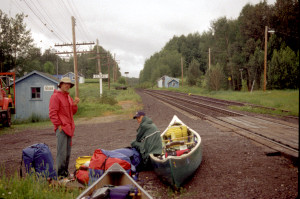 At around 11:00 we heard the deep rumble of an approaching train, and we prepared for its arrival with great anticipation. But once again, it was only a freight train.
The Via train finally arrived at around 11:40 -- about three and half hours late! We had planned to take photographs of the train as it approached, but when we saw that the locomotive was red-and-grey, we thought it was just another freight train. To our surprise, the train had two locomotives, and the second one turned out to be the blue-and-yellow one we were expecting. By the time we saw it, though, it was already passing us, and we were too busy gathering up our gear to pull out the cameras again. The train stopped rather quickly, and within 5 minutes we had the canoes and gear into a boxcar and were ready to go. We hadn't really thought much about where we would end up on the train; so we were not surprised to find ourselves simply standing in the boxcar for the duration of the 45 minute trip to Folyette. A conductor took our train fare, then returned to the regular passenger cars, leaving us with a couple of older fishermen who were apparently riding the train from Peterbell to Foleyette. (We had camped one night in Peterbell during our Missinaibi trip the year before.) One of the fishermen owned a cabin there and mentioned that, as he was boarding the train, a small party of canoeists got off with the intention of paddling the Missinaibi all the way to Moosonee on James Bay. Larry and I were surprised to hear this because Peterbell is so much harder to reach than Mattice, the usual starting point for that trip.
About five miles east of Elsas, the train slowed to acrawl as it passed a culvert repair project in progress. Apparently this was the destination of the work crew that had left Elsas on the single locomotive earlier that morning. Once we were past the repair work, the train resumed its 70kph speed, and we reached Folyette at around 12:25. Then we pulled the canoes and gear out of the boxcar just as quickly as we had put them in, and within a few minutes the train departed.
Mary, co-owner of Missinaibi Headwaters Outfitters, was waiting for us at the train station with the Previa. But she had to go pick up some other canoeists; so she left her assistant, Ivy, to ride back to Chapleau with us to settle our account. After we mounted the canoes atop the Previa and stashed the gear in it, Larry took the wheel, Ivy took "shotgun", and we drove to Chapleau. During the drive, we learned that Ivy was a freshman studying Geology/ Geography at Lake University in Thunder Bay. We found her surprisingly lacking in knowledge about this region and about Canada in general. For example, she thought the original growth trees in the area were jack pines when it's common knowledge that the logging industry had wiped out the magnificent stands of original growth white pine all across the Canadian shield. When she mentioned it was Canada Day, we asked her the origins and purpose of this holiday, and she had no idea.
We were close to running out of gas; so when we reached the outskirts of Chapleau, we stopped for fuel at Syd's Shell station, a familiar landmark from our Wakami trip: Jim Douglass and I had been stuck there for about an hour waiting for a flat tire to get repaired for his Aerostar. As we fueled the Previa, we noticed a sign for a "gas bar" -- in fact, we had seen similar signs at several places along the route from Foleyette to Chapleau -- so we asked Ivy what it meant. Apparently "gas bar" is the term Canadians use for the snack bar and/or convenience store often added to the automobile fuel and repair business of a service station.
At around 2:15 we finally reached the headquarters of the Missinaibi Headwaters Outfitters. It was tiny -- little more than a shed -- but it was crammed with canoe-related paraphernalia. We settled our account; Larry bought a couple of T-shirts; then we dropped Ivy off at Jean Guy's house. He still wasn't there, and after all the jokes we had made about his name, we were somewhat disappointed that we never got to meet him in person. Ivy recommended an Italian restaurant (I think) for lunch, but for some reason we gravitated back to Aux Trois Moulins. There Larry and I had dishes of very filling lasagna; Steve had a bacon cheeseburger; and Drew went for the pineapple pizza again. While we ate, we were surrounded by French Canadians chattering and laughing about some incident that had occurred "hier matin". We gathered it had been some kind of domestic uproar, but we never found out exactly what had happened.
We departed from Chapleau at around 3:00. From Chapleau I drove all the way to Gaylord. We paused once at a "rest stop" (which turned out to be just a pit toilet) near Bruce Mines, then in Mackinaw City to refuel, then in Gaylord to eat dinner at an Arby's. Instead of typical fast food fare, I tried to convince the crew to dine at a pasty shop, but no one was adventurous enough. Larry took over and drove the rest of the way to Brighton, pausing only once at a rest stop near Flint. We reached my house at around 1:30AM. Emily had made more pecan bread and coffee, which everyone enjoyed as we unloaded my stuff and said our goodbyes. Then the rest of the crew departed on the last arduous leg of the trip to Cincinnati.
J. Brown
July, 1995
Edits and Summaries:
L. Walter
February, 2006