White River, Ontario, Canada
June 22 - 29, 2001
The White River is (or at least was) one of Ontario's most beautiful rivers. It features numerous challenging rapids and waterfalls, including the extraordinary Umbata Falls. My first trip there in 1988 left me in awe. I planned a return trip in 2001 to share this wonder with my three sons before it was ruined by a damming project and increased clear-cut logging. Because we all had good whitewater skills, we were able to run many of the rapids that had necessitated arduous portages in 1988. It was a pleasurable outing, but I was unable to recapture the wonder of that first memorable trip.
Friday, June 22
The road north to Gaylord and a close encounter with a deer.
Several times during the week I had resigned myself to having to cancel the trip due to an ongoing crisis at work. On Thursday night, I confided to Drew and Brent that even though everything was packed and arranged, the trip might not happen. 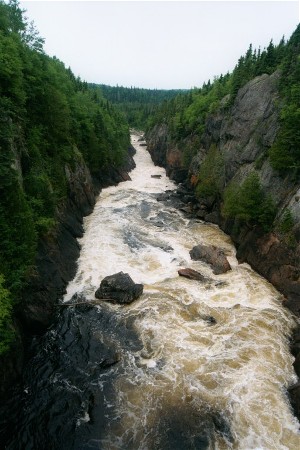 I didn't tell Chris, primarily because this was to be his first major canoe expedition in Ontario, and I just couldn't bring myself to break the news to him. On this Friday, it wasn't until 2:15 p.m. that I knew I would actually be able to go. It was the first time I smiled all day.
I was home by 4:00 and we pulled out of the driveway at 5:15, heading north on Interstate 75, the vintage green Old Town canoe strapped to the roof of the van. It was an uneventful trip for the most part. We stopped at Wendy's in Lima, Ohio for supper. The only event worth noting was a near miss of a deer at 1:00 a.m., just 30 minutes from our motel in Gaylord, Michigan. I had to hit the brakes hard and swerve left to avoid a serious accident. We were in bed by 2:00 a.m., setting our alarms for an early departure.
Saturday, June 23
The drive up the Lake Superior coast; camp at Hattie Cove.
We rose at 6:30 a.m., grabbing the free breakfast at the motel before heading north again. Soon we were across the border at the Soo and turning northwest on Canada Highway 17 skirting the Lake Superior coast. Near Wawa, we stopped for lunch at the Cedarhof Inn, a quaint, but unexceptional local restaurant. In anticipation of tomorrow's breakfast, we drove in to Wawa to buy doughnuts. I explained to the boys that there are always two things you can count on finding in every village in Ontario: a doughnut shop and a beer store. We were not disappointed.
When he took the wheel, Brent was particularly frustrated by the limited fare available on the few local radio stations. There was nothing on the air except a hockey talk show, country music, and a country/western melodrama. We arrived at Hattie Cove in Pukaskwa National Park around 4:00 p.m. It took awhile to get registered, find a campsite, and get set up. There was no running water available. Potable water was available from a tank delivered by truck. There were understandably few patrons of the park and we easily found a good secluded campsite in the woods.
Given the early hour, we had time to explore. We hiked over the rocky bluffs overlooking Lake Superior and viewed the beach landing site where we expected to end our trip in a few days. We ended the evening playing cards, having a small fire, and fighting off the mosquitoes.
Sunday, June 24
Put-in at White Lake; portage around the dam; running big rapids; Drew and Brent capsize; more rapids and portages; campsite near the "beach."
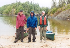
We were up by 7:30 a.m., eating doughnuts and breaking camp. 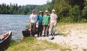 We met Carol Woito of Pukaskwa Country Outfitters in the main parking lot and loaded our canoe and gear onto her van. We left our van there as Carol transported us to White Lake, our starting point. After snapping a couple of pictures of us she was gone and we were left to load our canoes in the growing heat of late morning. We shoved off by 11:00 a.m. and paddled down the large lake into a strong headwind. We soon reached the small dam below which the river proper flows. We avoided all but a short portage on the right around the dam by paddling right up to the edge of the dam instead of taking out at the marked portage sign.
A short paddle brought us to the first rapids. After brief scouting, we ran the first rapid tightly along the left side to avoid a significant rooster tail in the middle. Everyone ran it without mishap, but the canoes took in much water and we had to stop and bail. We stopped for lunch at the end of the portage trail we had avoided by running the rapid.
Just down river was a long series of significant class II - III rapids with large haystacks and numerous rocks. It would have been possible, although arduous, to line the canoes along the left side on the intermittent rocky shelf beneath low hanging branches. That is what I had done on my prior trip on this river in 1988. However, training and experience make impossible rapids look possible. Chris and I ran the rapids first, while Drew and Brent observed from the rocky shore. We ran into trouble immediately, hitting submerged rocks, broaching, righting, then finally finding a clear path through the big haystacks and taking shelter in an eddy just before another rock garden.
Then Chris and I watched from the rocks while Drew and Brent took their turn. They ran the first sections well and had an exciting ride until hitting the last rock garden where a submerged rock caused the canoe to broach. 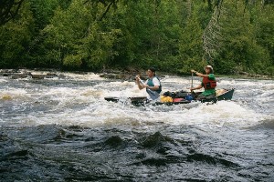 Drew in the stern had to leap from the canoe to avoid a capsize, which in turn destabilized the canoe again causing Brent to bail out as well. The canoe took in plenty of water but never did capsize. The boys made it over to the bank, canoe in tow, somewhat bruised and battered from the unexpected swim in rough water. Once we got the water out of the canoes, we waded through the edge of the rock garden before reentering and running the balance of the rapids.
Further downstream, we came to a small waterfall and rapid with a portage trail on the right. We portaged our gear to the end, then ran the canoes through the big drop over a ledge and eddied back to the right to pick up our gear. Generally, we were able to paddle through most of the subsequent rapids we encountered.
Next, we arrived at another big drop over a ledge with a 405-meter portage on the right. The drop was not runnable, so we did the full portage with the canoes. At the end of the trail was a small campsite in the woods just above a sizable sandy beach strewn with large rocks and driftwood. It seemed like a good place to stop. We set up our "kitchen" on the beach using an overturned canoe as a table and building a great driftwood fire. We dined on freeze-dried Sante Fe chicken, garden vegetables and cheesecake, sitting around the fire with the sound of the rapids in the background.
Although the boys claimed to be tired, they had enough energy to participate enthusiastically in games of baseball and various improvised track and field events employing rocks and driftwood. 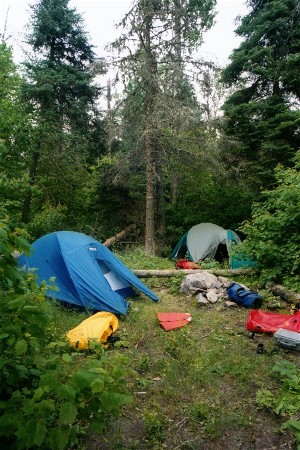 They had a great time.
Monday, June 25
Portages and rapids; difficult portage around Angler Falls; logged river bank; camp beside the rapids.
We were up by 8:00 a.m. and on the water by 10:00. By noon we had reached a portage on the left around a rocky ledge and waterfall. This was the spot of one of my favorite campsites in 1988, but we didn't pause long. Instead of using the portage trail, we paddled up to the rocky ledge and portaged a shorter distance over the rocks. We had our lunch a short ways down river, staying in our canoes to avoid the insects.
On this day we ran most of the rapids we encountered thereby avoiding lengthy portages. However, Angler Falls portage could not be avoided. It was a very difficult 630-meter trail with significant uphill sections and treacherous footing through boulder fields. The exceptionally warm weather made it even worse. Initially, we took a wrong turn and had to climb dramatically uphill to get back to the proper trail, an unwelcome task when carrying a heavy unbalanced load. We worked so hard on this trail that we barely glanced at the cross erected to commemorate a drowned paddler and we spent little time sight seeing at the dramatic falls.
Following Angler Falls, we were dreading the upcoming 800-meter portage, but we ended up running the extensive rapids all the way up to the edge of a significant waterfall. We then faced only a negligible portage and we were on our way again. A stretch of flat water followed before we came to more swift current. At the next short rapid, we saw the intrusion of logging for the first time. Loggers had degraded the forest right up to the waters edge on the left bank next to the rapids. We saw no people, but one logging truck was visible.
We stopped to camp at the next portage, 80 meters around a ledge. 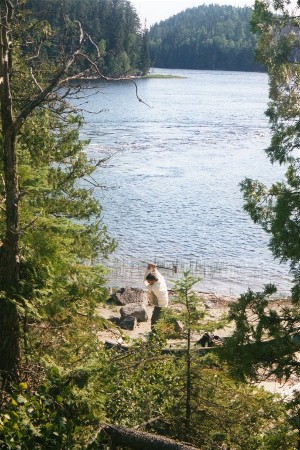 It was a wonderful spot next to the water rushing over the ledge. We set up our kitchen and built our fire on the rocky peninsula near the water. There was just enough room up the hill in the forest for our two tents. We were pretty tired and it was very buggy and hot, so we went to bed early.
Tuesday, June 26
Strong winds; man overboard; difficult scouting with a swim; tough portage; great lunch spot; grouse, bear, and beaver; campsite with difficult access; moose intrusion at dusk.
We rose at 8:00 and had embarked by 10:00. We paddled into a very strong head wind for a good part of the day. At times, the wind whipped up 2-3 foot waves that splashed over the bow and we were occasionally assaulted by sudden gusts of 30 miles per hour or more. Most of the morning was spent paddling into the wind on a long straight stretch of the river. Whenever we reached a sheltered area, we would stop to rest.
The first portage of 580 meters lay at a bend of the river. Drew and Brent had reached the portage, but as Chris and I paddled out from a sheltering bank into the full force of the wind a sudden gust hit us broadside, tilting the canoe and blowing the plastic map case into the water. As I desperately reached for the map case, the canoe was further destabilized and I had to leap from the canoe to avoid a capsize. The wind continued to render our recovery attempts futile until Drew and Brent paddled back to assist and I was able to crawl back aboard. Fortunately, it was a warm day and the cold water felt pretty good.
When we reached the portage, we found that the rapid was difficult to scout. There was no room to walk along the steep shore and a small rock island in the center of the river blocked our view down stream. Since I was already wet, I dove back into the cold water and swam for the rock island. I underestimated the strength of the current, the weight of my wet clothes, and the slipperiness of the rock, with the result that I was nearly swept downstream. Fortunately, I was able to find a purchase on the rock and pull myself ashore. My scouting paid off. We were able to avoid the first part of the portage by shooting over a small ledge between shore and island and running a short but significant rapid that followed before taking out on the right just before the river crashed through a ravine ending in a waterfall. Even so, the portage was about 400 meters and necessitated a detour through the brush to circumvent a fallen tree. On the way, we encountered a wild grouse.
We paddled for another half hour on flat water, then pulled out on a sheltered rock shelf on the left side, perfect for docking, stretching out, and having lunch, which we did. It was our favorite lunch spot of the trip.
The wind continued very strong the rest of the day. It was mostly flat water, but we ran a few rapids, including some significant haystacks near the large sand dune that served as a makeshift campsite in 1988. Along one stretch of the river we saw a black bear ambling along the shore. It looked us over carefully, then bounded off into the trees. We also saw a beaver along this stretch of river.
We were exhausted by the time we reached the vicinity of the 170-meter portage. We had covered many more miles on this day than I had planned. A campsite here was marked, but not very accessible. To reach it, it was necessary to climb up through a narrow gully through which a rivulet cascaded. It was a difficult climb partly because the soil was loose, sandy, and wet. The campsite was in a clearing out of sight of the river, situated on a granite outcrop. At the back of the site was the ATV trail that eventually leads to Umbata Falls. The site was a bit trashy and we were too tired to enjoy it much anyway. We used the gas stove instead of taking the trouble to start a fire and, following a perfunctory meal, we retired to our tents and away from the bugs. Although we were tired, we still played cards (separate two-handed games in each tent), before drifting off. Around dusk, we were awakened by the loud clumsy progress of a moose along the trail. Chris was the only one who actually saw the moose, but the sound was unmistakable.
Wednesday, June 27
The long, hot, Umbata Portage; hike to the falls; a refreshing swim; more significant portages and waterfalls; campsite in Pukaskwa National Park.
Everyone slept in a little longer in the morning. The boys were not up until 9:00. Soon we were struggling down the narrow slippery ravine and loading up the canoe. We stopped briefly to climb up the steep house-sized granite boulders on the right bank to scout the rapid that curved around behind them. We ran the rapid, primarily large haystacks, and avoided the 170-meter portage.
Soon thereafter, we reached the dreaded Umbata Portage, 2240 meters over a rocky trail on a very warm day. It was very hot, tough work, and the trail seemed interminable. Chris, who had been enduring the teasing of his older brothers about not carrying his weight, had sworn that he would carry the Duluth pack all by himself for the entire distance on this trail. The Duluth was perhaps the heaviest and most uncomfortable of our packs. So, he loaded it on his back, filled his hands with other paraphernalia, and headed out. He undoubtedly suffered for it, but he accomplished the feat. I told him to remember the date because that was the day he became a man.
When we had finished the portage, we gathered our lunch packs and water and hiked up to see Umbata Falls. This was a much more difficult trek than I remembered. We had to boulder hop for a few hundred yards, then bushwhack our way to a horrible overgrown and winding trail up the side of the gorge. 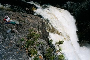 Considering that everyone was already exhausted, hot, and dehydrated, I nearly had a mutiny on my hands. At last we reached the top of the falls where we had our lunch. Everyone agreed it was an extraordinary place at the precipice of a canyon with a huge waterfall crashing into the abyss and mist roiling up into the air. The enthusiasm was still a bit muted, however, due to our state of exhaustion, and Drew was suffering a headache due to dehydration. Afterwards, we returned down the trail to our canoes, loaded up, and paddled out to a rock bar where we went for a refreshing swim/bath. It was around 3:00 p.m. and we actually felt surprisingly revived after immersing ourselves in the cold water.
So, we pushed on down river for another 4 or 5 miles, encountering 3 portages of 350, 300, and 97 meters around waterfalls. All of these portages were pretty tough, and each started with a dramatic uphill climb. The last one went straight up and then straight down over a ridge. Across from the waterfall near this portage was a campsite hidden above the rocks. We would not have known it was there had I not read about it in a journal posted on the internet.
We were in the Pukaskwa National Park now, so the campsites were more developed, with bear boxes, fire rings, and sand boxes for the tents. This site even featured an outhouse in the woods. Although we were physically spent, the beauty and convenience of this place revived us and we soon had our camp set up and a roaring fire to enjoy, looking out across the water at the impressive waterfall. We dined around 9:00 on red beans and rice and/or Cajun chicken with rice plus peas and carrots and for dessert, peaches and cream pie (all freeze-dried, of course). We made it to our tents after dark and drifted to sleep listening to the waterfall.
Thursday, June 28
The last portages; rope bridge over the gorge; lunch below the gorge; fog and a calm Lake Superior; return to Hattie Cove; we head home.
We were ahead of schedule, so we got up late, around 9:15. It was cloudy with sprinkles and a lot cooler. We ate breakfast and broke camp in a light rain.
It was a short paddle to the 217-meter portage on the left around a large waterfall. We paddled out below the waterfall to take a few pictures before continuing on to the next portage (our last as it turned out) of 690 meters. At the start of this trail, we took the short side trail to the rope bridge over the gorge. 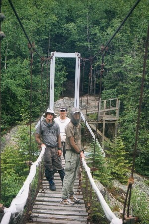 We spent awhile here bouncing on the bridge and admiring the view before trudging back to pick up our heavy burdens.
The first leg of the portage trail was a long exhausting upward climb. To make matters worse, it continued to rain thereby making the trail slippery and treacherous. However, there were enhancements to this trail such as wood planking through the boggy areas and stairways and railings. Near the end of the trail, out on the rocks overlooking the bottom of the gorge, was another favorite campsite from 1988. We stopped here to explore and Chris found a handmade primitive bow and arrow someone had left behind.
We spread out our lunch on the rock slope near the waters edge. Here we could enjoy watching the water shoot from the gorge and disrupt into various channels through the boulders. It was a dramatic sight.
It continued to sprinkle intermittently. We discussed whether to stop here and camp or push on to Lake Superior, and maybe even on to Hattie Cove. The consensus was to push on. So we loaded up and headed toward the mouth of the river. As we approached the lake, it became colder and rainier and we donned our raingear. We checked out the 20-meter portage that avoids the mouth of the river. It was a short trail to a campsite and to a view of the lake itself where we could view the wind and weather conditions. As we looked out across the lake, we were amazed at the clarity of the water and at how calm the lake was. It was also very foggy and visibility was limited to about 20 or 30 yards. Given these calm conditions, it made sense for us to keep paddling. Lake Superior is notorious for sudden storms and strong winds. We could be wind bound for days if we waited.
So, we went back to our canoes and paddled out the mouth of the river into the lake and the fog. 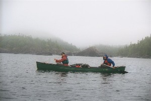 As we passed through the mouth, a group of sea kayakers had just come in to take a break. They were the first people we had seen since embarking on White Lake. Due to the limited visibility, we stayed close to shore and close together. Staying close to shore was not a problem because there were no waves crashing on the rocks. There was almost no wave action at all. It was a very beautiful experience paddling on the huge, yet mostly unseen lake, passing the rough, rocky islands and peninsulas in the fog and mist. The water was extremely frigid and the air was cold as well. I navigated with compass and map, but was still surprised when we arrived at our destination so easily and unexpectedly early. We arrived at Hattie Cove at approximately 4:00 p.m.
At Hattie Cove there were signs posted warning of bears in the area. In fact we saw a bear as we drove away from the campsites. There was still no running water or place to change at Hattie Cove, so we decided to just start driving. As always, the return to civilization was a bit jolting. We had a late dinner at Arby's on the Canadian side of the Soo, then continued on across the International Bridge to the U.S. We soon located a Holiday Inn Express with vacancy. We all had much-needed showers and called home.
L. Walter