White River
Ontario, Canada
June 24 - July 2, 1988
This early trip remains a favorite of mine. It was dramatically more challenging than our first trip, and the scenery, including Umbata Falls, was stunning. Our developing skills were severely tested by frequent boulder-strewn rapids, dangerous waterfalls, the cold waves of Lake Superior, and seemingly endless and precipitous portage trails. The trip was also replete with minor incidents we still reminisce about: the $50 bet, the sandy omelette, the grouse attack, the phantom bear on the road, the lost paddle disaster, and the big one that got away.
Friday, June 24
Evening drive north to Michigan; short sleepless night.
Rob and I left just before 8:00 p.m. and headed north on Interstate 75 toward Ypsilanti, Michigan. My Toyota van was loaded with packs and equipment and my Old Town Tripper was lashed to the roof. Rob provided me with a martini to go and took over the driving responsibilities.
The drive was uneventful. Sometime after nightfall, Rob purchased a 6-pack of Rolling Rock beer at a gas station. I purchased a package of sunflower seeds. Drought-crazed insects pelted the windshield in alarming numbers.
Around midnight, we reached the outskirts of Ypsilanti. Jim's directions specified an exit at Michigan Avenue, but there was no exit labeled as such. Consequently, we wasted some time backtracking and searching before finally reaching Jim's house around 12:30.
Both Jim and Emily were up, but there was little time or inclination to socialize. Rob and I crashed on a sofa bed by 1:00 a.m. The sofa bed had apparently been designed by a Nazi sadist. I was too excited about the trip to get much sleep anyway.
Saturday, June 25
Windy drive north; lunch in Wawa; White River Trading Post; shuttle to the White River; a friendly bet; embarking down the river; four portages; first camp.
We were up at 3:30 a.m. and hit the road north (U.S. 23) at 4:07. Emily had provided homemade cookies for our early morning sustenance. Rob and Jim dozed intermittently while I drove. We stopped around 6:30 a.m. for breakfast at an Elias Big Boy just north of Standish, Michigan.
It was a beautiful sunny day with strong gusty winds. It was also hot and dry. Air conditioning eventually became necessary. The farther north we travelled, the stronger became the winds. It became very difficult to keep the van straight on the road. We alternated drivers more frequently. The canoe acted like a sail atop the van and despite the tightness of the lashings, it began shifting from side to side.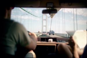 Going over the Mackinac Bridge, we feared we might lose the canoe to the winds. Whitecaps were visible on the water below.
The winds continued as we crossed into Ontario, Canada. The scenery along the coast of Lake Superior was beautiful and the winds were causing very large waves to crash on the rocky beaches. We would be canoeing on this lake in a few days and we wondered if it would be anything like this when we ventured out from shore.
In Canada, it suddenly became cooler and damper. The sky clouded over and it occasionally misted. We were dressed for the midsummer drought of Ohio and Michigan. It was a shock to step into the brisk wind . We stopped at a typical tourist trap/curio shop that advertised "See Our Moose." The moose was stuffed and hitched to a carriage out front so that tourists from the States could pose in front of it for embarrassing snapshots. We naturally followed suit, shivering in the wind, then retreating to the van for snacks. Instead of airconditioning, we now made use of the car heater.
We stopped at an A&W in Wawa, Ontario for lunch. Jim and I had cheeseburgers while Rob had something called a "whistle dog." The "obligatory moose" head was mounted on the wall of the eatery. Wawa was pretty dreary, with gravel streets and a weatherbeaten look.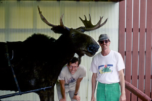 Its primary tourist attraction was a giant statue of a Canadian Goose.
We reached, the town of White River at 4:15 p.m. and made our way to the White River Trading Post. There we introduced ourselves to Lorraine Wilson and her business partner Allison (or Alice?). The Trading Post had everything: T shirts, curios, video tapes, groceries, hunting and fishing supplies, boat and canoe rentals, showers, delicatessen, toys for the kids, various provincial licenses, magazines, and much local color. We purchased sandwiches for supper, camping licenses, Rob's fishing license, and extra lures. At Allison's urging, we also purchased PIC mosquito exterminator. We also paid Lorraine $50 for shuttling our van to our destination at Hattie Cove.
After an hour of shopping and talking, we boarded the van once again. Lorraine and Allison drove us westward on Highway 17 and then south along a gravelled lumber mill road. We stopped at a point where the road crossed over the river. This road was not on our topographical map. According to Lorraine, this access point was below two sets of rapids that we otherwise would have had to portage around. It was impossible for us to know exactly where we were on the river and Lorraine was unable to pinpoint it for us on the map.
At this point, we were not sure how much we could trust Lorraine's judgment in these matters. She had made it very clear to us from the beginning that there was no way in the world that we could accomplish our trip as scheduled. She repeatedly predicted that we would not make it in less than 10 days. Consequently, we were starting to feel a little insecure about our plans. Perhaps we were being overly ambitious and unduly optimistic. After all, Lorraine had canoed the river before. This was her country, not ours.
We piled out of the van. It was getting colder and wetter. Before unloading the car, we made our way down the steep bank, over logs and rocks, to the river. It was our first view of the White River and we were instantly exhilarated by the sight. It was a beautiful river, even exceeding our expectations. Here it was relatively narrow, perhaps 30 feet across. The cold water rushed over the rocks beneath the bridge and flowed briskly to the west through a lush green forest. Our fears about the effect of the drought were dispelled.
Next came the difficult job of unloading the van and repacking our packs and fitting all the bulky and unwieldy gear into the canoe while balancing on slippery rocks. Lorraine and Allison seemed to enjoy the spectacle, occasionally poking fun at us, and marveling at the amount of baggage we were taking with us. Considering the weight of all that gear and our obvious ineptitude in assembling and stowing everything, it was not surprising that Lorraine bet $50 that we would not be back in eight days. Rob instantly accepted the bet.
At 6:30 p.m., with a light rain falling, we pushed off from shore and headed down the White River. We were giddy from exhaustion, cold, and excitement. We were finally on the river.
Between 6:30 and 9:00 we covered about 5 miles and hiked over 4 portage trails. The portages were well marked and skirted rushing rapids. The first two were very easy, relatively flat trails of approximately 150 meters each. The third portage was longer and rougher going, stretching for 380 meters over fallen trees, slippery rocks and boggy areas. Midway through this portage was an attractive campsite that tempted us, but we had a goal of at least 5 miles and intended to reach the horseshoe bend in the river where our map indicated another established campsite. The final portage was 215 meters and at its end was an even more beautiful campsite situated on the river bank next to a rushing rapid. This was our intended destination and we were pleased with ourselves for reaching our goal.
It was 9:00 and getting dark. We inexpertly set about establishing camp. Much of our time was spent hunting for dry firewood. The woods was damp, but we eventually got a blaze going by using the fire ribbon. We sat by the fire eating our deli sandwiches, drinking dri-lite (our beverage for most of the trip), and feeling very good. After cleaning up the campsite, stowing the gear, and hanging the food packs from a nearby tree, we crawled into the tent and were asleep by 11:30 p.m.
Sunday, June 26
Beautiful morning of a long day; Mr. Marsupial; morning portages; we run our first few rapids; lunch along the rapids; our canoe becomes a barge; near disaster in the rapids; canoe-loading mishap below the trestle; unexpected rapid around an island; swampy terrain; beach camp on Pakoawaga Lake; numerous leeches and a sloping tent site.
We awoke at 7:00 a.m. It was a beautiful, chilly sunny morning. A light mist hovered over the river. Our campsite was even more beautiful in the morning light. We were in a good mood, delighted with our surroundings and excited at the prospect of embarking on our first full day on the river. This was to be our longest and perhaps toughest day: 17½ miles and nine portages. Our destination was Pakoawaga Lake. We knew that if we could make it that far today, that we could finish our trip as scheduled, despite Lorrain's skepticism.
We spent considerable time taking pictures around the campsite, making a fire, and organizing our packs. Breakfast was freeze-dried blueberry granola with milk plus Rob's "camp" coffee. The granola was a hit (which was fortunate given our considerable supply) and Rob's coffee was also a crowd pleaser. Camp coffee was prepared by boiling water in a large pot, pouring in coffee grounds, and then skimming coffee off the top after the grounds settled to the bottom.
Much of our equipment was new and untested, especially Jim's and Rob's equipment. Generally, this was not a problem, as the equipment was of much higher quality than our last trip together. However, unfamiliarity occasionally caused minor delays or problems. This morning, Jim announced that he had lost one of the strap clips for his new waterproof portage pack. Our search for the small black buckle was fruitless. Later in the day, Jim discovered that it had been clipped to his pack all along.
Rob had new rain gear--dark Green heavy gage non-breathing urethane. The pants were extended halfway up his torso by suspenders and there were pockets everywhere. A particularly large flap pocket was located at stomach level and Rob frequently stuffed spare lashing straps, bags of granola, and other essentials into this pocket creating a prominent bulge. This feature caused him to denominate himself "Mr. Marsupial." Today, even though there was not a cloud in the sky, Rob persisted in wearing these rain pants because of the convenient pockets. He persisted despite the warmth of the afternoon sun.
The "Mr. Marsupial" name stuck. Before long, Rob had dubbed Jim "Mr. Plowhorse" for his determined plodding through the forest and brush burdened with excessive gear. I eventually became the "Taskmaster" due to my unpopular decisions regarding which rapids to portage and how many miles to travel at the end of a long day. In addition to devising these nicknames and regaling us with his usual litany of jokes, Rob got in the habit of singing out "I'm home dear!" or "Honey, I'm home!" (in the vein of Ward Cleaver returning home to June on "Leave it to Beaver") every time Jim would stumble or do anything clumsy. This refrain was frequently heard during the course of the trip.
With all of the packing and picture taking, it was 10:00 before we finally left our first campsite on the White River.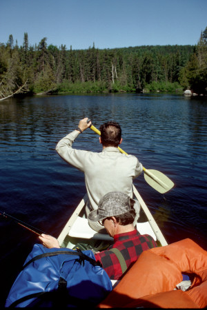 We pushed off from the bank, paddled out into the morning sunlight, around a small island and then, for the first time, turned due north. The river and the day were picturesque.
We paddled for approximately 2 miles before the day's first portage. The portage was on the left for approximately 395 meters around rapids that were mostly out of sight behind the foliage. The trail was relatively easy and clear. Rob carried the canoe the entire distance and I took several pictures.
A paddle of another 2 or 3 miles brought us to our second portage of approximately 300 meters. Although the initial stretch of this portage was a tough uphill hike, once at the top, it was straight as an arrow and flat. The trail paralleled the railroad tracks that were just above us about 30 or 40 yards. This land had obviously been cleared and graded by the railroad company. Halfway down the trail we found a small unappealing campsite with a trail running perpendicular, one route heading up to the railroad tracks and the other down toward the river. On our first carry with packs and gear, we continued onward and came out at a marshy reedy area by the river. Someone had left a canoe nearby in the brush. We dropped our gear and returned to the campsite. By taking the small trail to the river from the campsite we discovered that this was the point from which to embark. Access to the water was from a low rock ledge extending out into the river. We had carried our gear too far. We returned for the canoe and remaining gear. I carried the canoe this time. We pushed off from the intermediate access point and then paddled down river to the reedy area to retrieve our other gear.
The next two or three miles closely paralleled the railroad tracks. Our course was westerly again now and the tracks lay to the north. At several points during the day, our route came close to the tracks and we heard or saw trains.
The next four portage trails were close together.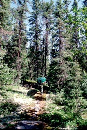 The river here was fast and exciting. We carried most of our gear on the first trip along the first two portages which were connected. The trails were fairly flat and grassy, weaving through the trees along the river bank for about 600 meters. Scouting the river was fairly easy given the terrain, the lack of brush. Jim and I went back to the canoe, tied in the remaining gear and ran the first set of rapids while Rob took pictures of us. We then slowed our pace allowing Rob to run down the trail for more pictures of us as we continued through the second set of rapids. The run was fast and exciting but required little maneuvering. Nevertheless, our whitewater confidence was greatly inflated. After the run, we pulled in to pick up Rob and the gear before continuing down river through swift water to the next portage. This rapid. Was beyond our capabilities and required a portage of approximately 145 meters. The trail ended in a beautiful open spot, tree-shaded with rocks to sit on by the water's edge. We had our lunch here of cheese, crackers, peanut butter, etc. The water was still swift and turbulent here and the sun was warm. We were enjoying ourselves.
We soon embarked and came to the fourth set of rapids. It was more challenging than the other two we had run. It required a 45° turn in swift water to miss a huge boulder, and there were numerous other rocks to avoid, but, assuming we could stay on course, it appeared to be a fairly straight shot with no complex maneuvering required. We scouted carefully for submerged rocks or other hazards, but it seemed runnable. This time we attempted the run fully loaded with Rob aboard. Our assessment of the rapid was correct, but, as I very quickly realized, our fully loaded state converted our canoe from a maneuverable whitewater craft to a barge. For a moment I didn't think we would make the turn around the boulder and I was relieved when we did, although not by the margin I had intended. Ahead was a straight shot through turbulent water, but we were directly on course. Then, without warning, we hit a submerged rock head on and turned sideways in the current. I expected to upset in the icy water but the canoe, true to its new barge identity, was heavy enough to resist the strong current. That momentary resistance enabled Jim and I, both madly prying and drawing, to right the canoe and propel it around the rock. We immediately hit another submerged rock and began to broach again and again managed to pry our way around the rock without upsetting. It was a close call and it taught us a lesson: Fully loaded canoes are not maneuverable in whitewater and they are vulnerable to submerged rocks that an unloaded canoe would obliviously skim over. We were happy to learn this lesson without paying more dearly.
A mile's paddle on flat water brought us to a bend in the river where we turned northward into a stiff wind. For 5 miles we continued northward roughly parallel to the railroad tracks. The water was flat with one or two swift areas. At last we came to a short portage on the left side that took us up over a railroad trestle, along the tracks for 30 or 40 yards, and then steeply down to a large pool below the rapids. After all the gear and the canoe had been portaged, I climbed back to the tracks to take a few panoramic pictures from this high vantage point. Below, Jim and Rob were busy loading the canoe. They had loaded three large bags and Jim was attempting to load the fourth by stepping into the canoe off center and swinging the pack in. The canoe abruptly moved away from shore and tipped. The bag fell in the water and the canoe took in water.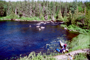 The canoe had to be unloaded and bailed out before proceeding.
After this minor fiasco, we again beaded north, passing through a small stretch of swift water and then beneath the highway 17 bridge, an abrupt reminder of civilization.
Shortly thereafter, we unexpectedly came upon rapids and a short portage on the right side. Our map/pamphlet incorrectly indicated this portage further to the north. The rapids were very fast but had a runnable passage through the left center. If these rapids were run, the strong current would carry us around the left side of a large island. We could not tell what lay behind the island perhaps a waterfall or more rapids. Given our recent near disastrous experience running rapids and the strong current around the blind side of the island, we initially opted for portaging. However, the short portage trail was blocked by fallen trees and was virtually impassible. Since we had no choice, we reluctantly prepared to shoot the rapids. We paddled back into the calmer water above the rapids, lined ourselves up along the left side and entered the V. Our barge weathered the heavy water and we were once again elated and confident. Going around the left side of the island took us out of the way, but the swift current made it worthwhile. We continued northward with eight portages behind us for the day and just one more ahead.
The portage was a mile ahead on the left side. Rob carried the canoe the entire 200 meters. We were all weary but worked efficiently as a team, intent on making Pakoawaga Lake before day's end.
After this portage, the river was flat and the terrain became more swampy. The river was bordered by low brush and anemic looking trees. There was an occasional small sand bar. We meandered with the river for 4 miles through this low country as the sun sank toward the horizon. It was becoming an endurance test.
The White River enters Pakoawaga Lake, winds around and then reenters through a wide reedy area. It is difficult to tell where the lake begins and the river ends. We explored this area, searching for established campsites, but everywhere looked marshy, buggy, and undesirable. We were tired of paddling around and it was 8:30 p.m., so we finally set off across the lake, intent upon a sandy beach on the far side.
It was a long paddle, but we finally reached shore around 9:00. We made camp on a sandy beach, tossing most of our gear over some large bleached out fallen trees lying near the treeline. There was evidence of logging operations here--rusty iron cables lay in the sand, and there was an old campsite back among the trees. We set up our latrine in the old campsite and pitched our tent on the sand where we hoped it would be less buggy. We set about making camp, collecting drift wood for a fire and stringing a long clothesline. We discovered animal spoor and at first thought it was a bear's. That made us uneasy, so we eventually persuaded ourselves that it must have been a moose. There were fresh moose tracks along the beach. Rob and I paddled the canoe out beyond the marsh reeds to get fresh water.
As night fell, we had a large fire and listened to loons for the first time on this trip. We ate freeze-dried mountain chili and corn, but skipped dessert because we were too beat. Later, clearing dishes and brushing teeth along the shoreline, we discovered hundreds of leeches in the shallow water.
We were very tired but very pleased with ourselves for reaching our goal. We now knew that we could travel this river on our terms, that we were in control of our schedule and that Lorraine did not know what she was talking about.
We gratefully crawled into the tent that night to escape hoards of insects and to get some much needed rest. Unfortunately, the tent was pitched on a slope and Jim kept slipping off his sleeping pad most of the night. Rob complained of the effects of the ranch chili and also expressed his suspicion that some feral furry beach creature was rustling around outside and possibly constructing a nest in his shoes which be had left just outside the tent door. As for me, I just slept, soundly and well.
Monday, June 27
Crunchy omelette; lining a rapid; 2 successive portages; strong winds; Elora Lake; tough portage along railroad tracks; unexpected aid via pickup truck; across White Lake in the rain; White Lake Provincial Park; wet and miserable camp at dusk; Jim climbs a tree; eating and sleeping amid intense mosquitoes.
We awoke at 8:00 a.m.. Rob's suspicions were confirmed-something had nested in his shoe during the night and then crept away before dawn. We slowly began the process of making breakfast and breaking camp. Rob cooked on the folding grate over an open fire. We bad bacon (the real stuff), camp coffee, cheese omelette, and bagels. Rob had scuffed some sand into the omelette so that it was a bit too crunchy to be enjoyed.
It was 11:30 before we finally boarded the canoe. We set off across the lake with the wind in our faces and the skies rapidly clouding over. A strong wind was in our faces most of the day. It continued to be cloudy and we were barely missed by rainstorms during the morning and early afternoon.
The first few miles after leaving the lake, we slowly meandered through more of the low marshy terrain. There were a number of small oxbow lakes and plenty of wild ducks and other fowl along the way. Eventually, we crossed under Highway 17 again, passed the confluence with the Bremner River, and came to our first portage of the day.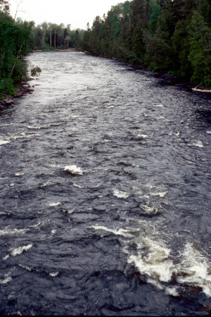 The portage was supposed to be along the railroad tracks on the left, but my extensive scouting failed to turn up any sign of a trail through the rough shrubs and rocks. The terrain was too impenetrable for easy bushwacking, so we lined the canoe through the rocky rapids, Jim and I handling the lines while Rob stayed in the canoe, paddle in hand, to fend off rocks.
A half mile down the river, we encountered another set of rapids and another portage, this time with a discernable trail. The mosquitoes were becoming a problem now due to the weather conditions and heavy doses of Muskol or head nets were essential on the trail. This portage was about 300 meters long and avoided some difficult rapids. I stayed behind on the first trek to repair the portage yoke which had become loose.
The third portage of 200 meters was very close to the second one. We grumbled about the frequency of unloading and loading, but these rapids were much too long and rough to run and the terrain was too steep and rocky for lining.
After the third portage, we turned in a more northerly direction into a very strong wind and significant waves. The river was wider here, with less shelter from the wind. We fought our way to the next river bend and found more shelter from the wind as we headed west again. We stopped paddling here and drifted. We needed the rest and it was lunch time. We eventually found a sheltered area by a rock ledge where we sat in the canoe and finished our lunch of cheese, crackers, and pemmican bars.
The river became wider as we made our way toward Elora Lake. Motor boats had access along this area, although we did not see any. At one point we saw several cabins on a bluff above the river on the right. Rob wanted to pull in and buy some beer. I refused, somehow believing that by refusing to acknowledge the existence of this outpost of civilization I was not allowing it to intrude on the "purity" of our wilderness experience. Rob, not subject to the same delusions as myself, was unhappy with my decision.
Rain appeared imminent as we passed through Elora Lake, but again we were spared a shower. Elora was a good sized lake, but somehow seemed to be more of an excessive wideness in the river than a real lake. Perhaps this was because of the sheltering islands, peninsulas, and narrow channels connecting its parts. In any case, we soon passed through the lake and into the somewhat narrower river passage.
We were traveling parallel to the railroad tracks again, this time to our left side. We were searching for the major one mile portage to White Lake that had to begin before the tracks turned inland again. At last we saw the obvious grassy docking point just before the swifter waters leading into a long series of rapids. The portage was marked by a few pieces of red tape on the bushes leading up the slope to the railroad tracks above.
The portage followed the railroad tracks for about 2/3 mile, then ran onto a dirt road by a bridge crossing the river. The final 1/3 mile was along the dirt road then sharply right through a weedy area and down the slope to a rock strewn promontory on the shore of White Lake. The railroad tracks were rough on feet. Jim and I were wearing our poorly padded neoprene surf sneakers and both the sneakers and our feet paid a price that day. As we struggled along the railroad tracks burdened with our heavy packs, we could hear and sometimes see the river far below us on the right side as it roared through numerous rapids. We had a good overview at several points and, upon reaching the road, we could walk out on the bridge for an even better view. The portage seemed endless. As we went down the road for the first time, we saw what looked like a black bear sitting by the road in the distance. As we came closer, we discovered that it was an Indian woman apparently awaiting a ride. We said "hi" and trudged on. This road led to the Indian reservation at Mobert and cars or trucks occasionally passed.
The second trip down the tracks, with the canoe, was even rougher. We were already exhausted and our shoulder muscles and feet ached. We frequently substituted the position of canoebearer, but exchanging the 80 pound canoe for an equally heavy pack brought little relief. When we finally reached the road, we put down the canoe and rested for awhile.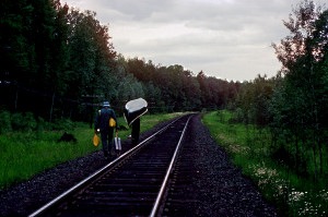 It was at this point that an Indian in a pickup truck happened by and offered to transport us and the canoe the rest of the way. We gladly accepted the offer although, at the same time, I resented this 20th century intrusion into our wilderness experience. I kept my thoughts to myself, however, realizing that this might be an unpopular view under the circumstances.
At last we all struggled down the slope with our canoe and packs and started across White Lake around 5 or 6 o'clock. White Lake is huge. It is bordered by a few lodges and cabins and the White Lake Provincial Park. We expected to see power boats on this lake and our expectations were realized. They were mostly smaller fishing craft.
A major rain storm was approaching from the north, so we propelled ourselves through the water as quickly as we could. Our first objective was Regan Point, a long peninsula with a long submerged sandbar extending well out from the shore. We paddled northward around the point and then westward a few yards out from the sandy beach. Millions of flies swirled in clouds along the beach. We could see sheets of rain falling across the lake to the north. We watched it progress swiftly towards us. As we reached and rounded the next point of land where we expected to dart across a leg of the lake to the Park headquarters, the rain hit hard. We immediately pulled into the beach just around the point and groped through our packs for our rain gear. After the rain had abated somewhat, we paddled across the lake to the Park.
There was no one around--just a few buildings, small boats, and vacant swimming beach. Jim availed himself of an indoor (or at least sheltered) pit toilet and seemed to enjoy it despite my pointed criticism of his disloyalty to the true wilderness experience.
It was chilly and wet and we could not find the canoe trip registration point we were looking for. It was also getting late in the day and we were tired and hungry. So, we embarked once again into the lake. We discovered the registration point a short distance down the lake. I went ashore to fill out the registration card, then we set off again through the drizzle and wind towards the southwest. We wanted to find a campsite well away from power boats and the lights of Mobert, the small ugly Indian town across the Lake to our left. We paddled a long ways, but everywhere seemed the same: wet, overgrown, inaccessible, buggy and inhospitable.
Finally, I saw a stand of white birch on one of the points to our right and went ashore to investigate the possibilities. There was an old camp there on the slightly elevated point among the birch trees. It was wet and buggy but would have to do. It was 9:30 p.m. and dusk.
There were signs of old logging operations here--old rusted cables and some wooden benches and racks that were now rotten and falling down. It was wet and cold and we could not have a fire because all the wood around was sodden. We toiled to set up camp before dark. Jim decided to undertake my usual job of tossing the hammer tied to a rope over a branch and down so that we could hoist our food bags out of the reach of bears. He took careful aim and tossed it perfectly through a small crotch of a tree far above the ground. Unfortunately, the hammer caught and Jim had to change shoes and climb the tree to retrieve it. It was a rather spectacular feat under the circumstances and Rob and I were relieved to see Jim return from the treetop with no more thanscraped shins and chafed fingers to evidence his heroic exploit.
Rob cooked supper on the campstove. It was cajun rice with chicken--good and spicy. We sat in misery on the cold wet ground in the darkness using our flashlights to find plate with fork. The mosquitoes were in thick clouds everywhere and they were voracious. Jim and I had our headnets on, surreptitiously slipping a forkful of food beneath the net to mouth and back again before the pesky critters could get in. For some reason, they didn't seem to bother Rob as much, or perhaps he was just psychologically in tune with the insects that night.
For the first time, we used the PIC mosquito exterminator in our tent. It worked well. When we finally crawled into the tent at midnight, we had the satisfaction of seeing the little devils drop from the walls of the tent to the floor. Something about that sight appealed to the savage soul.
We set our alarm for 7:30 a.m., intent upon getting out of this place as soon as possible. The mosquitoes buzzed in an endless frenzy outside our tent. Inside, we snuggled into our sleeping bags, warm and comfortable at last, and passed out.
Tuesday, June 28
Sunny morning; Squato; portage around the dam; first portage nearly missed; alternating rough portages and runable rapids; lining difficult rapids; near disaster at an unexpected ledge; catching a paddle and a fish; lunch before a long portage; respite by the falls; grouse attack; beautiful camp and a well-deserved feast.
We crawled out of the tent around 7:30 a.m. and had a cold breakfast of blueberry granola and bagels. The bugs were still around, but it was sunny and breezy. The wind was cool and now blew from the east. We were glad to be leaving this buggy, wet, enclosed area for the windy openness of White Lake.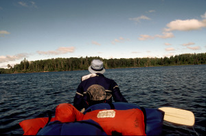 We shoved off from the sandy beach at 10:00 a.m., the wind at our backs. A stowaway caterpillar was also aboard, clinging to Rob's fishing pole. We dubbed him, "Squato," a joint tribute to the Indian lands we were passing through and the practical realities of a wilderness latrine.
We soon passed beneath the railroad bridge spanning the lake. Printed in large white letters across the side of the bridge was: "THIS IS INDIAN LAND." As we paddled toward the narrow end of the lake, we encountered a couple of small motorized fishing boats.
The first portage of the day was along the right side around the dam, from the lake to the river on the west side. Approximately ½ mile below the dam was a series of significant rapids and portages. The portages were not marked and we missed the first one. We were drawn into swift water and pulled into the right bank just above the rapids. Realizing that we had gone too far, we attempted to back paddle. This didn't work, so Jim and I got out and pulled the canoe backwards through the. swift water. The water was clear and cold. Smooth multi colored rocks formed the river bed. Finally, we made our way back and across to the left bank where we were able to get up the bank to the portage trail that had begun somewhere farther upstream. We portaged from this point. It was an arduous trail, up and down, over and around rocks and trees.
The portage trails along this section were all interconnected. After completing the first arduous segment, we elected to carry only gear over the second segment and then run the rapids rather than face another rough portage with the canoe. Fortunately, the rapids at this point were fairly easy. Jim and I ran them with a partly loaded canoe while Rob took pictures of us from the left bank. It was a fairly long, straight stretch of water with a fast current and standing waves.
After pulling back in to the left bank to reconnoiter and unload, we were astonished to see two people and a canoe further downstream. They were obviously scouting the big noisy rapids that lay just ahead. Rob went down the trail to see if it was safe for us to proceed downriver to that same point, very close to the dangerous rapids and to make sure there was reasonable access to the trail from there. He soon motioned us forward and Jim and I pushed out and down to the rocky point. The other canoeists were gone, but Rob had talked to them briefly. They were Canadian and they had lined this set of rapids after a first tentative attempt at running them.
It was hard to believe that anyone would seriously contemplate running these rapids in an open loaded canoe. The waves were huge and so were the rocks. It was a magnificent and exhilarating sight. Along the left side where we stood was a relatively flat shelf of rock extending into the river. After some scouting, we decided to line our canoe through these rapids. Given the velocity of the water, we had to proceed with great caution. Finally, we reached a point where lining was no longer feasible.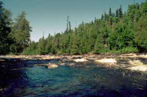 We ran through a short stretch of minor rapids with Rob lying flat atop the packs and then put into shore again. At this point, Rob took a pack and set off for the end of the portage trail while Jim and I scouted and prepared to run the rapids and meet up with Rob downriver. Rob was to signal us from the trail's end so that we would know where to put in.
While Jim and I prepared to make the run, Rob fished downriver. Jim and I pushed off into the swift water and were doing well until we discovered that there were significant rapids around the final bend in the river, at the point where Rob was fishing. This was a surprise. Caught in the swift current, we back paddled and moved toward the left bank. There was nowhere to get ashore, but we managed to grab the overhanging branches of a fallen tree. This was a precarious position, caught in the rushing water, grasping the branches while the canoe tried to rush out from under us toward the steep ledge ahead. We could see Rob's fishing pole sticking out from shore just around the bend and just below the ledge that had us worried. We could hear the turbulent water and see foam kicking up below the edge, but we could not tell if it was possible to shoot over this ledge without overturning or swamping in the big waves below. Only Rob was in a position to see the pattern of water over the ledge and he couldn't hear us over the sound of the water.
Jim and I elected to pull ourselves backwards against the current hand over hand on the overhead branches, and anything else we could grab on to, to a point where the shore was accessible through the brush. This was a tricky maneuver, and at some point Jim obliviously lost his paddle in the rushing water. It wasn't until we reached shore that he discovered it was missing.
Meanwhile, Rob, fishing in the pool below the rapid, saw the paddle flowing over the ledge in the rough water and assumed the worst. He expected that gear, broken canoe, and perhaps even bodies would soon follow over the ledge. The paddle became caught in a large circular eddy below the ledge and along the left shore. Rob followed along the bank in an attempt to retrieve it, but the paddle stayed too far out in very deep water.
By this time, I had scrambled ashore and bushwacked my way through the heavy undergrowth to the trail and then down to where Rob was. Rob and I waded into the water and attempted to reach the paddle which continued to circle, now in the big waves, then circling into calmer water again. Finally, Rob was able to snag it with his fishing line and reel it in. As he lifted it from the water, he was very surprised to find that he had also snagged a walleye, his first catch of the trip.
After scouting the big rapid over the ledge, I returned with the paddle to where Jim waited. The standing waves were quite large, but there was no choice but to run through under the circumstances. Jim and I pushed off and through while Rob waited below. It was a great ride, but we took in substantial quantities of water. Below, we turned into the eddy, picked up Rob and the remaining gear, and pushed off down the river through the final rough water. We were relieved to have gotten through this area without serious mishap. It had taken us over two hours to cover that relatively short stretch of river.
The river widened and we soon came to shore again on a rocky point on the right.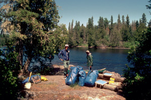 It was a campsite and the beginning of another portage trail. We were exhausted from our recent efforts. We unloaded the canoe and sat down on large paralell logs to have our lunch in the sunlight and cool wind. We had bagel chips with peanut butter, applebutter, cheese, and chocolate survival bars.
Our after lunch portage was long, more than 400 meters, and tough. It was so overgrown that we had difficulty finding our way. At one point, Rob became utterly lost and gave up the lead in frustration. We trekked with most of our gear to the end of the portage trail, then returned and carried the canoe and remaining gear about 100 meters. At this point, we got in the canoe and paddled our way through two sets of relatively easy rapids and stopped at a large rock outcropping, just short of thundering rapids/falls. We stopped here to rest and take a lot of pictures. Jim and I carried the canoe over to the edge of the falls for a prop. It was a beautiful place and we thoroughly enjoyed ourselves. Finally, and reluctantly, we began the final stage of the portage with the canoe and remaining gear to the trail's end. It was along this stretch that Rob was attacked by a wild grouse hen. 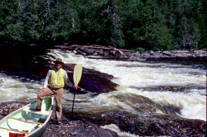 It came hissing and fluttering and Rob backed away yelling "Get back you! Get away!" Unimpressed, the grouse surged forward. I could hear this fracas ahead of me on the trail and I ran forward thinking that Rob was under attack by a bear. When I saw the grouse, I rushed forward yelling with the two paddles in my hands and ran it off the trail into the brush. Rob thanked me for saving his life and we continued on our way.
We paddled onward for less than a mile before arriving at the next portage on the right side. This one was short, perhaps 95 meters, and very scenic. It skirted the edge of the river as it plummeted over and around large rock outcroppings. We took a few pictures but didn't stay long.
It was now late afternoon and we were beginning to think about camp. It had been a taxing day and we needed some relaxation. For the next 2½ miles, the river was relatively flat and calm except for one small section of swift water. Rob caught his second fish, a good sized pike, trolling along this flat stretch.
At 6:30 p.m., we came upon a portage on the left side around rapids/falls. It was still sunny and beautiful. The path led steeply upward and through some trees where it opened up into the most beautiful campsite we had ever seen. It was high and windy, with views of the river on all sides and the sound of the rushing water below. It was replete with a rustic table/pantry, bench, and, rock hearth. There was even a flat, perfectly level rock on the ground for our campstove. At the other end of the short trail was a sandy beach stretching along the edge of the pool formed below the falls.
We were elated. After exploring a bit, we set up camp and stretched out a long clothesline along the trail to air out all of our clothing and sleeping bags. Rob set about preparing a feast for dinner.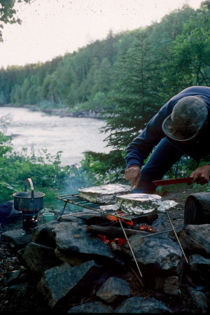 The entree was fresh fish with pineapple, baby shrimp and tomatoes baked on the grate over the open fire. This dish was also especially enjoyable because we now no longer would be forced to carry the canned goods on our backs over the portage trails. Also featured on the menu were freeze dried stromboli, green beans, and soup. For dessert there was both cheesecake (an immediate favorite) and chocolate pudding. All of this was topped off with B&B before a roaring fire.
Unfortunately, Jim had a backache. He spent a considerable amount of time lying on his camprest pad on a therapeutic slab of rock near the rushing water. Rob did some fishing and we all took pictures of everything in sight. Water rushed through a fissure in the large rocks extending across the river and this provided running water for washing dishes, brushing teeth, etc. It was a beautiful, cool, bug-free evening.
Wednesday, June 29
Jim becomes ill; difficult portage around Angler Falls; another long portage; we encounter a group of Canadians; more portaging and rapid running; confluence of the Oskabukuta River; abandoned logging camp; camp on a sand dune island.
We were up at 7:00 a.m. It was a beautiful morning but quite cold, with the wind out of the northeast. Jim felt very sick--headache and nausea. Rob cooked a big breakfast of freeze-dried eggs, hash browns, real bacon, and camp coffee. Jim was unable to eat much, so Rob and I knew he must be very sick. Despite the cold, I washed my face and hair in the rushing water down on the rocks. Even Jim managed to wash his face. He spent some time huddled on a sunny rock at the water's edge trying to shake off the nausea while Rob and I broke camp.
We pushed off at 9:45, the wind at our backs.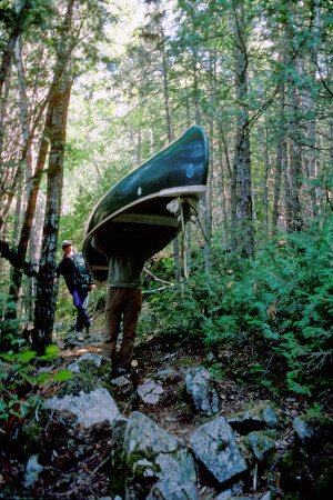 A paddle of three miles brought us to the first portage on our left. This portage was very long and difficult (perhaps 1000 meters) around a gorge and, presumably, Angler Falls. There were discrepancies between our maps, so we were never certain about the location of Angler Falls. A cross at the beginning of the trail memorialized the death of a canoeist who died in these rough waters in 1975. It was a rather solemn and sobering sight. The trail was especially difficult because it traversed rocky, steep terrain. One area in particular was a steep garden of angular rocks. The rocks were sharp and there were very few flat, safe places to put one's feet. On our second trip through, with the canoe, we halted at this spot to consider how we were going to get the canoe across. Finally, I volunteered to take it across solo. I came close to making it across when I ran out of places to step and fell hard on the rocks with the canoe on top of me. Fortunately, I wasn't injured and was able to continue on.
Rob found a new Swiss army knife along this trail, apparently dropped by another canoeist. We spent some time taking pictures along the edge of the gorge.The water through the gorge was a swift writhing foam. It was difficult to imagine how any canoeist could tempt these waters and survive.
The trail ended abruptly in a pile of driftwood about fifteen feet above the water.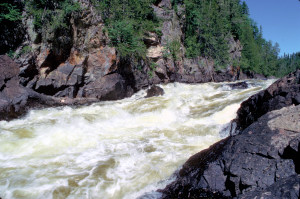 The water was still very turbulent at this point and there appeared to be more rapids around the bend to the right. I scaled the cliff face, climbing a long ways above the river for a better view of the river ahead. There was whitewater and we would have to run it.
Finally loaded again, we pushed off into the current, followed the swift water around the bend and through the whitewater. We took in water, but it was an exciting ride.
The next portage was less than a mile away on the left side. It was another long one--650 meters--but we handled it very efficiently, passing off the canoe like a baton as each carrier wore out. On the first trip down the trail, we overtook two Canadians carrying their canoe in tandem. The rest of their party (a total of 6 men and 3 canoes) was at the trail's end, down a steep incline to the pool below the falls. We talked with them for awhile. They were friendly, but I think we all felt a little shocked at encountering other humans out there in the wilderness. They were from various locations in western Canada, having come east to find canoeable water. The drought had apparently affected much of Canada to the west. They had fished out a badly broken canoe from back in the gorge and were unsuccessfully attempting to remove its padded portage yoke. They were gone by the time we returned once again with our canoe and we did not see them again.
The next portage was less than a mile away on the right side. I briefly scouted the short rapid and we ran it fully loaded without incident. A short ways further down river, we came to another portage on the right side. This one was short (70 meters) and scenic, running alongside a powerful rapid that cascaded over large rocks. We stopped here on the rocks overlooking the rapids to relax and have lunch.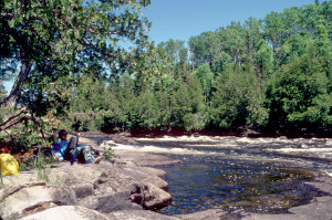 Rob fished in the pool below the rapids and lost one of my lures. Jim, was still very sick but stoicly persevered.
Three miles of flatwater paddling brought us to our next portage on the right. It was long, around 580 meters, but relatively flat and straight, running along an old logging road, now overgrown with waist-high ferns. The trail ended on a sandy beach, an easy put in spot.
We pushed on deeper into the wilderness. Access to civilization was now many miles away. Jim seemed to recover somewhat during the afternoon, which was a great relief--the nearest doctor was several days away.
It was nearly 6 miles of flatwater to the next portage. On the way, we passed through a stretch of swift water running deeply between rocky walls, with small unpredictable whirlpools spinning about and tugging at the canoe with subtle power. We passed the confluence of the Oskabukuta River and searched vainly for the campsite we expected to find there. Rob managed to lose my second lure somewhere along this stretch of river.
Two miles further along, late in the afternoon, we continued to search for a campsite, but everywhere was the same--overgrown, brushy and buggy. At one point I scrambled ashore and climbed up the steep eight foot bank through the brush and discovered a former campsite back among the trees, but it was generally undesirable and inaccessible, so we wearily pushed on.
We came to swift water, passed through and then entered into even swifter water heading into rocky rapids ahead. Failing to see any sign of a portage, we pulled near the right bank to reconnoiter. We then ran the initial section of rapid water and pulled over to the bank again, just short of the heavy water. From this point we lined the canoe through. There were fresh footprints in the mud indicating that the Canadians, too, had lined this section.
As the sun fell from the sky, we forged ahead, still searching for that ideal campsite. We rounded a bend to the right and discovered the remains of a log pier against the right bank. Rob and Jim scrambled onto the pier and up the steep sandy bank to explore while I held the canoe close to shore. They found an abandoned logging camp replete with garbage and rubble. It was an acceptable campsite, but only as a last resort.
We knew we could not go farther down stream at such a late hour (it was after 8:00), so we pivoted the canoe and headed back the way we had come to search out a better spot. Along the west shore there was an unusual topographic feature, a thirty foot high sand bank covered with grass and a few trees. It was virtually a sand dune island with stagnant swampy water along the back side. It turned out to be a good, albeit strange, campsite.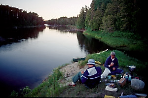 On top there was a great view of the river and a nice breeze to keep most of the bugs away, except for some persistent gnats. We bad no fire or clothesline. There was just enough room to pitch our tent and stack our gear. Obtaining water was particularly difficult as the sandy banks caved in when stepped upon. Supper was cooked on the small stove carefully balanced on the few rocks we were able to round up. We had freeze dried shrimp Cantonese with green peas & carrots and apple cobbler for dessert.
As darkness fell, we put the food bags in the canoe, piled our remaining gear on the ground, covered it with a tarp, crawled into the tent and passed out.
Thursday, June 30
Morning otter sighting; old logging outpost; running rapids; lunch on a rock shelf; long portage around Umbata Falls; camp below the falls; hike to Umbata Falls; dinner fire by the rapids; marauding blind mouse.
Jim was up at 7:00, completely recovered from yesterday's illness. By the time Rob and I crawled out of the tent at 8:15, he had already shaved and begun packing. It was another fine sunny day. Breakfast was blueberry granola, bagels, and camp coffee. It was 11:15 before we finally got everything repacked and shoved off from our sandy island.
We paddled north northwest against a stiff wind and waves. It was nearly five miles to the first portage. Along the way, Jim saw an otter. I saw the splash and Rob, as usual, saw nothing but Jim's back. Also, along the way, we stopped and climbed the steep and slippery bank on the right to explore another old logging outpost.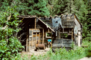 In the dilapidated cabin was a makeshift stove made from an oil drum.
We came to the first portage on the right side. All along the shore there were large flat rock outcroppings. We scampered along these rocks scouting the big rapids. Lining the canoe from these rocks would have been relatively easy, but we were in an adventurous mood and there seemed to be a straight shot through the rapids. We carefully strapped in the cargo, canoed out to mid stream, lined up for the chute, and then paddled forward into heavy water. It was a terrific ride through large standing waves. We took in more water on this rapid than on any other during the trip.
Just a few hundred meters downstream, we encountered a second smaller rapid and ran it as well. Immediately below this rapid, still in the swirling strong current, we stopped paddling and allowed Rob to fish from the canoe. Then we pulled into shore for lunch. The river here was bordered by a high rocky shelf. We tied the canoe to a rock and sat on the rock shelf in the sun to eat and watch Rob fish. Rob lost another lure among the submerged rocks. It was a pleasant site, one we reluctantly left. 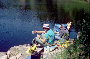 Jim nearly left his camera on the rocks as we departed.
A short paddle, just short of a mile brought us to the Umbata Falls portage, the longest of the trip (1½ miles). The trail went straight up the steep bank on the right where it soon crossed onto a rough dirt track road. It was still a beautiful sunny day and relatively warm.
As we trudged along the trail with our packs, it was quite hot and very buggy. It seemed that the trail would never end. Finally, the trail turned back towards the river and down a steep slope. Strangely enough, while going down this long slope, we discovered a discarded toilet seat. At the trail's end, the road continued on across a wooden bridge. Power lines crossed here as well. Here there was clear evidence of the presence and abuse of man. The campsite was rather unappealing, but below it next to a swift rapid was an extensive broad flat rocky shelf and a broad rock-strewn beach extending toward the gorge. We dumped our packs at the end of the portage with the thought of pushing on down river, then headed back up the trail to retrieve the canoe and remaining gear. Along the way, we encountered a large woodchuck.
The final trek of 1½ miles with the canoe nearly did us in. Our shoulders, backs, and feet were aching and we had to rest periodically. By the time we reached the end of the trail, any thought of pushing on down river had vanished.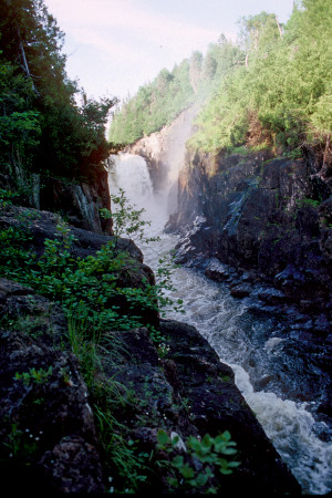 We did not like the power lines and bridge, but the proximity of the falls just up the gorge, the nice rapids, and the lateness of the hour persuaded us to stay.
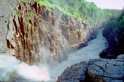
Jim and I went down to the water's edge, removed our shoes and socks, and soaked our tortured feet in the frigid water until they were numb. Afterwards, we grabbed our cameras and headed up the gorge in search of the trail that would take us to Umbata Falls. The trail was difficult to find and was poorly maintained. We struggled over, around, and under fallen trees. Suddenly, we emerged from the dense forest onto a rocky promontory above the magnificent Umbata Falls. Right at our feet it roared over the precipice and fell 100 meters into the narrow gorge below. Despite our exhaustion, we scampered about on the rocks taking pictures and absorbing the extraordinary scenery.
On the return trip, Jim and I bushwacked our way through rough undergrowth to the very edge of the gorge. By lowering ourselves down to a ledge, we were able to get a partial view of the front of the waterfall.
On the way back to camp, we attempted a shortcut across a small channel of water by placing driftwood logs over it, but Rob fell in. At the campsite, we discovered that a chipmunk had gotten into Rob's trail mix by biting through the plastic bag. 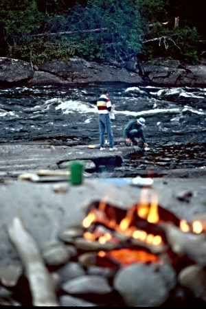 The chipmunk was obviously familiar with humans and made several forays into camp.
We built our driftwood fire on the rocks by the river and spent our evening there by the rushing river and away from the bugs. We dined on chicken a la king, peas, soup, and mocha mousse pie--freeze dried, of course. After dinner we had liquor and I worked on journal notes while Rob and Jim competed at throwing and skipping stones across the river. As darkness fell, we labored at securing our camp for the night. The mosquitoes were vicious. Earlier, we had discovered a primitive, yet by wilderness standards, luxurious, latrine. Back in the scrub trees was a wooden box replete with toilet seat. It was almost civilization. Before turning in we also discovered a brazen little mouse,apparently blind, moving about in the center of our campsite. It seemed oblivious to our presence and was unaffected by our flashlights. We hung our food bags from the bridge, more to keep the food from chipmunks and mice than to discourage bears.
Friday, July 1
Late breakfast of pancakes; Pukaskwa National Park; portages within the park; lunch below the falls; rope bridge over the gorge; Chigamiwinigum Portage; camp with an extraordinary view; Rob loses a big one; unexpected visit from a Kalamazoo salesman; last evening in the wilderness.
We crawled out of the tent at 7:00 a.m. to a bright, sunny day. A heavy mist was rising from the water. Rob cooked blueberry cinnamon whole wheat pancakes. This took a long time, but the pancakes were delicious. We ate breakfast on the rocks in the sun next to the river. For awhile we considered running through the big rapids in front of us with an unloaded canoe just for fun. However, given the lateness of the hour, we decided to skip it and push on. It was very warm and buggy around the campsite as we broke camp.
We embarked at 10:30 a.m., Rob paddling for the first time. He paddled for approximately two miles up to the first portage on the right. We were within the boundaries of Pukaskwa (pronounced "pack a saw") National Park.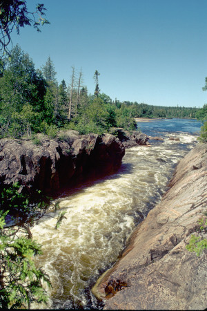 All of the portages within the park were well marked and reasonably well maintained. The first relatively short portage trail started up a steep incline and ended in a dry creek bed filled with rocks and fallen trees. A double carry was necessary to get the canoe over these obstructions. We rested for a few moments in this shady spot and then paddled the short distance across the pool below the waterfall/rapid to the next portage around a narrow gorge filled with turbulent water. We stopped for several pictures before pushing on.
We paddled four miles of flat water before reaching the next portage. This portage was very short, but it went steeply up and then steeply down over a peninsula to avoid a waterfall.
A paddle of less than a mile brought us to the next portage of 217 meters on the left side. This trail skirted a very large, beautiful waterfall. The trail itself was part of the National Park hiking trail and was in very good shape. We had our lunch along this trail out on a rock cliff overlooking the roaring rapids below the falls. Lunch included "easy cheese," crushed crackers, peanut butter, jelly, spicy beef sticks and Tuscany Toast. While we were eating, we saw some hikers on the trail, but they ignored us and made their way back the way we had come.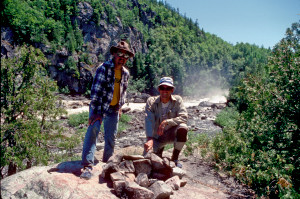 After lunch, Jim walked back to get some close up pictures of the waterfall, then we canoed out below the falls for more pictures.
A short paddle brought us to the final portage of the trip. The trail was 690 meters and began on the left side. The trail was called Chigamiwinigum Portage and went around a waterfall of the same name. The "Falls" was magnificent, but was more of a long precipitous rapid through a deep gorge than a traditional waterfall. Before portaging, we took a short trail to our right along the gorge and crossed over a swinging bridge above the gorge. The bridge was constructed of steel cables and wood planks. This was an exhilerating experience and we took our time enjoying the scenery and taking pictures.
Finally, we left the bridge and treked back to start the portage. The first leg of the trail was a long steep incline. At the top was a wooden canoe rest and a registration box.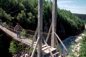 The trail was quite long but was very well maintained, including wooden walkways and stairs in some locations. This did not appeal to us because it was too civilized and manicured.
We made our way to an established campsite and decided to stay there and get up early the next day for the Lake Superior Journey. While Rob went to check out the fishing possibilities, Jim, and I waundered along the trails in the woods and discovered a much better campsite nearby on a rocky point with a beautiful 270-degree view of the rushing water. We began transferring our gear to this new site and at one point, going back through the woods, I discovered Rob and Jim trying to force their way past two trees with the canoe wedged tight between them. It was reminiscent of the "three stooges."
Jim and I set up camp while Rob fished from the rocks below camp. Rob was casting his lure into the swift water below the falls when he hooked a huge walleye. He yelled up to me to bring the camera. I grabbed it and ran back to the cliff's edge in time to see Rob slip and fall on the rocks. The line was severed on the rocks and the fish got away. Rob was upset about losing it, but was also exhilarated at having hooked it and brought it in.
Rob and I set about making a fire and preparing dinner while Jim took off down the hiking trail to explore. He was gone a long time, but returned in time for beef stroganoff, green beans almondine, soup, and pineapple cheese cake. While sitting around our driftwood fire, Rob burned a hole in his shirt. A hole was also burned in Rob's canoe chair while Jim was sitting in it.
Around 8:30 p.m., a salesman from Kalamazoo waundered into camp. He talked mostly with Rob and Jim because they were civil to him. I was antisocial, reluctant to acknowledge that another human was among us. The salesman was backpacking by himself for eight days. He told Rob and Jim that he had lined up as many as nine people to go with him, but they all backed out. He carried a tripod and camera accessories and was after the ultimate picture of the falls. He was camping at the site we had abandoned earlier and he asked if he could hang his food pack from the same high cross bar we were using. We sensed that he might wish to be more sociable and we did not encourage him. We later joked that he might be the raving lunatic who had written unintelligible gibberish in the canoe register back up the trail.
The evening was spent with dinner, fishing, and packing.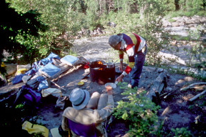 We packed up as much as we could in anticipation of a 6:00 a.m. departure. We all agreed that, physically, this campsite was the best we had ever experienced. There was a fire ring, logs to sit on, an outhouse, sand boxes for pitching tents, and an extraordinary view. However, there was a feeling of civilization about it, as if we were in Yellowstone National Park with people behind every tree.
We did not need the PIC that night. The bugs gave us a reprieve, perhaps because of the chill in the air. Upon bedding down for the night, we discovered that the ground (sand in a box) slanted toward the river so that our heads were down and our feet up. Jim and I adjusted by putting clothing under our mattresses, but Rob just suffered.
Saturday, July 2
Early departure; turbulent water at the mouth of the White; paddle on Lake Superior; landing at Hattie Cove; return to White River Trading Post; the trip home.
We were up at 5:00 a.m. and quickly broke camp without breakfast. We carried the canoe and gear straight down the rocks below our campsite to the river. By 6:00 we were on our way. It was very chilly and cloudy, but there was no wind. We traveled the 2½ - 3 miles to Lake Superior uneventfully intent only upon getting there without delay and before the winds came up.
Just before reaching the outlet to Lake Superior, we saw an unexpected portage sign far off to our right. Apparently, this portage was used to avoid the turbulent waters at the mouth of the river. We decided to forge ahead through the mouth anyway rather than backtrack and face yet another portage. The waves at the mouth of the river were indeed daunting and our initial venture into the lake caused us some trepidation as we bucked up and down with the powerful waves and avoided the inhospitable rocks along shoreline. The waters of the lake had a different feel, a deep, powerful, and intimidating feel. The angle of the canoe had to be carefully monitored to avoid a broach. It took us awhile to become accustomed to the waves, but soon we became more confident and I set a course north to north northwest out about ¼ to ½ mile from land. We followed this straight course instead of skirting around the islands and into the bays as we had planned. Consequently, we made great time and soon found ourselves around the final headland in search of Hattie Cove. The entrance to the cove was difficult to find, but at last we entered a narrow rocky passage into the quiet, calm waters of the cove. Canoes and small motor boats were beached on the sand.
It was just before 8:00 a.m. and still very chilly. We searched out the van in a nearby parking lot, drove it around through the public campground closer to the canoe, and unloaded our gear for the last time. Most people around the campground were still asleep as we pulled out in search of coffee.
We drove quite a ways before we found coffee. We stopped at the general store/gas station/tourist cabin office near White Lake. This turned out to be the very place that Rob had wanted to stop for beer on Elora Lake several days earlier.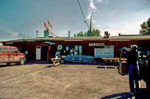 In fact, it was a complete liquor store, as Rob repeatedly pointed out.
We also stopped in the town of White River to buy souvenirs and to surprise Lorraine Wilson. After briefly recounting our adventures and purchasing White River Trading Post t-shirts, we were on our way again. Lorraine was undoubtedly relieved that we did not try to enforce our bet.
The trip home was fairly uneventful. Rob bought some Molson Gold in Canada, shared some of it, but drank most of it himself and eventually passed out through most of Michigan. He awoke for our lunch at McDonald's in Grayling, Michigan and also purchased cookies from a girl selling baked goods at a gas station for her church. Later, be regained consciousness long enough to have us pull over so he could buy fresh cherries at a roadside stand.
We made a brief stop in Ypsilanti to drop off Jim and his gear and then Rob and I pushed on through the night, arriving home between 2 and 2:30 a.m. thoroughly exhausted.
L. Walter
July, 1988