Lower Missinaibi River
Ontario, Canada
June 26 - July 5, 1996
The Missinaibi is a classic route of great historic significance, once serving as a major trade route for native peoples as well as the Hudson Bay Company. Also, a number of canoeists have lost their lives on this river, especially at Thunderhouse Falls. The most recent fatalities were two Ohio canoeists in 1993. We had paddled the Upper Missinaibi in 1994, and we completed the journey to James Bay with this trip two years later. This is only the start of a journal covering the first couple of days. Jim did not complete his journal because JD had videotaped the adventure making a journal seem superfluous. Nevertheless, Jim informs me that he still has over 75 pages of notes from the trip and may be inspired to finally complete the narrative. This trip deserves a journal, but the photos will have to suffice for now. It was a tough but enjoyable journey featuring dramatic falls and rapids such as Thunderhouse; an island campsite infested with large biting deer flies; a fierce thunderstorm that forced us into the bush for shelter; three 30-mile paddling days into a strong wind; transformation of the landscape from granite shield to alluvial muskeg; culture shock and a sleepless night near Moosonee; a power boat trip to James Bay and a long train ride back to Cochrane.
Tuesday, June 25
Rendezvous in Brighton; travel arrangements; departure.
Based on a dialogue Larry and I had kept up on the Internet, I expected Larry and Alan to arrive at my house around 11:00PM on Tuesday, 25 June. Normally we would have tried to leave the previous Friday (21 June) to take advantage of two weekends, which would have allowed us a more leisurely paddling schedule. But JD had time restrictions which forced us into a narrower window.
Larry and Alan actually arrived around 10:35, the Tripper strapped to the top of Larry's Toyota van. This early arrival was a first, and Larry attributed it to the fact that Rob was not along. Rob had accompanied us on all our previous trips, and his entertainment value was undisputed. We were going to miss him and his antics on this trip, but maybe not the results of his antics, which tended to be counterproductive to the "objectives" of the trip. JD arrived about a half hour after Larry and Alan. Fortunately no one had run into any problems circumventing the construction on Brighton Road, the main thoroughfare from the freeway to my house. I had sent detour instructions to Larry by Internet and to JD by PROFS e-mail at work.
The plan was to transport all four of us, both canoes, and all our gear using JD's F-150 pickup truck. JD had found a used camper shell to put over the bed, and he had devised a metal pipe rack large enough to hold two canoes atop the shell. In the truck bed he had put a large inflated air mattress so that two of us could sleep while the other two were up in the cab. But once we had all the gear in place, there wasn't much room for comfortable sleep. JD and I had used this same arrangement for a canoe trip we had taken on the Buffalo River (Arkansas) around Easter; but on that trip, when we wanted to sleep, we had just pulled into a rest stop and made room for sleeping by moving some of our gear to the truck cab. We would have no such luxury on this trip: The plan was to stop only for fuel, food, and fundamentals.
After the traditional consumption of goodies prepared by Emily and the traditional groping around in the dark for awhile, we produced a few flashlights and got to work loading the truck with gear and securing the canoes to the rack. By midnight we were ready to depart.
Wednesday, June 26 - Day 1
Discomfort in the truck bed; the route north; breakfast in Sault Ste-Marie; truck passing incident; fires forbidden; log yard; Karpella's Camp; tent rental; unloading in Mattice; embarking down the river; Rock Island Rapids; Black Feather Rapids Portage; the teepee; camp on the rock outcropping; stove cooking.
JD started out driving, with Larry at shotgun. 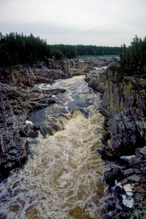 Alan and I climbed into the back -- somewhat of a struggle because the mechanism to hold up the shell's liftgate was broken. Once under way, we found the ride rough and noisy, and with truck lights coming in the back window I found it difficult to sleep. But Alan managed to fall asleep almost right away. Since there was no way to communicate effectively with the driver, I had to watch helplessly as JD took the wrong ramp onto the freeway and ended up heading west toward Lansing. Once JD and Larry realized they were going the wrong way, they consulted the map and devised an alternate route that would take us by Lansing and then up US-27 to join with I-75 near Grayling. This route is actually a few miles shorter than the usual route up US-23 joining I-75 in Flint; but it tends to be slower because it involves less freeway and encounters a number of traffic lights just north of Lansing.
As we headed north, the temperature dropped into the 40's, and the unheated shell became a refrigerator. JD had put a couple of wool blankets in the shell, but Alan and I had been using them as pillows. Now we unbundled them and pulled them over us. By the time we reached Sault Ste-Marie, we expected the weather to be downright cold, but it turned out to be only pleasantly chilly. Once we were across the border, JD stopped at the Family Chef restaurant where we had eaten breakfast on our Upper Missinaibi trip two years earlier. There we each had a variation on the "malt pancake" breakfast that is their specialty. Unfortunately the coffee was like swamp water. We choked down several cups only to ensure we'd be awake enough to complete the drive to Mattice.
After breakfast I took the wheel, with Alan at shotgun, and Larry and JD climbed into the back to try to get some sleep. Near Wawa I pulled off the road so that everyone could get the coffee out of his system. Larry climbed up an embankment to an area of trees and undergrowth to take what seemed like a world-record whiz. There he was beset by the trip's first significant swarm of mosquitoes. Meanwhile I crossed the road to investigate a track that went into the woods. The track led to a rather nice campsite right on the shore of Lake Superior.
Once under way again, we encountered a series of bridge construction projects as we approached White River. At one point I got frustrated poking along behind a large truck; so as we accelerated from a construction stop, I passed the truck in a "no passing" zone. A camper was heading for us in the opposite direction, and although I easily made it back into the lane in front of the truck, the trucker expressed his displeasure with a loud horn blast that aroused Larry and JD from their fitful slumber. A few minutes later, when we stopped in White River, Larry expressed his concern about the incident -- but he was concerned not about the risk of a head-on collision with the camper, but about the risk of being pursued by an angry trucker.
The weather in White River was pleasant: 65o, with just a few high cirrus clouds scattered across blue sky. We were encouraged that conditions for canoeing would be excellent. But as we entered the White River Trading Post to check for souvenirs, Larry spotted a dreaded "Feux Interdit" sign on the window. As we knew from a Chapleau River canoe trip Larry and I had taken the previous year, this sign meant we wouldn't (legally) be able to enjoy campfires during our stay in the wilderness. We could only hope that conditions were not so dry up in Mattice and parts north. But as we continued north, we saw a large sign near the road indicating that fire danger was "Extreme", and outside Hearst we saw several more "Feux Interdit" signs along the road.
At around 1:30 Alan, who had taken the wheel in White River, pulled over for lunch at a McDonald's in Hearst. After lunch we stopped for fuel at a service station just down the road. Across the road, and several hundred feet back from it, was the most enormous pile of logs we had ever seen: at least a half mile long and about fifty feet high. A huge mobile crane was picking up great bundles of logs as if they were handfuls of straw and moving them over to railroad cars. I went across the road to get some photographs of this spectacle.
Larry now took the wheel to pilot us to the Karpella's "camp" outside Mattice. We had used the Karpella's shuttle service two years ago for the Upper Missinaibi trip, and Larry had arranged for them this time to shuttle the truck to Cochrane, where they would meet us at the end of our train ride back down from Moosonee.  When we reached the Karpella's camp, we were greeted by Denise Karpella, a stout, talkative woman whom we had met briefly at the end of our previous trip. I was hoping to talk to her husband Owen to find out whether he had ever purchased another canoe after his offer-and-retraction to buy mine two years ago. But Owen was away shuttling some fisherman.
We plied Denise with questions relevant to our impending expedition. Denise expected the fire ban to be lifted within the next day or so because of some recent rain. She thought we would be OK with campfires. She also thought we'd be OK renting a tent for $7.50 per day ($67.50 total) to avoid the much steeper camping fee -- even though technically the tent rental avoided the $10 per person per day ($240 total) Provincial Park camping fee, but not the $5 per person per day ($120 total) Crownlands camping fee which appeared to apply in this case. Falling back on his extensive reservoir of legal wisdom, Larry decided that if we got caught, we could just blame it all on the Karpellas.
While Larry handled the financial transactions, the rest of us filled up our various containers with water from a faucet on the side of the Karpella's office and used the restrooms inside the office to change into our river clothes. Denise mentioned that the black flies were past their peak -- which surprised us because the season should have been running about two weeks late given the later-than-normal breakup of the ice on the rivers that May. We encountered a smattering of black flies as we filled the water containers, but nothing of real concern.
Once we were ready for canoeing, we all piled back into the truck for the short trip into Mattice. Denise rode with Larry and JD in the cab. The river packs and gear had been removed or relocated so that we could get to our river clothes, then thrown haphazardly back into the truck; so Alan and I had to contort ourselves to a mangled heap of paraphernalia as we rode in the back.
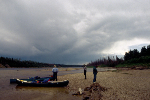
In Mattice we removed the canoes and unloaded the gear in the same park where we had taken out two years before. By 4:00PM we were ready to launch. The weather was still sunny, with a pleasant southwesterly breeze and temperature in the low 70's. As we launched, a small group of French-speaking girls and a woman (presumably the mother of one of the girls) were preparing to go for a swim. We bid them adieu and paddled out into the slow-moving current headed northeast. The water was about two inches higher than when we had taken out two years ago, but it was obviously lower than normal, and we were concerned about what this might mean for the runnability of rapids downstream.
Our first chance to test this concern came when we reached Rock Island Rapids about an hour later. 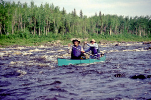 Larry had brought along a copy of Hap Wilson's book about the Missinaibi. According to Wilson, the best approach here was to ferry over to the rock island in the center of the rapids (hence the name), and scout the water conditions from there. We did that, but from the island we still found it difficult to decide whether to run or portage. The route was pretty obvious -- we'd have to back-ferry out into the main current, then run the big water flowing just to the right of the island. The problem was that the current looked as if it would tend to pull us farther right, away from the island and into some ominous pillows and possibly out into some mountainous haystacks. Even if we managed to keep away from those obstacles, we'd have to make a hard pull to the left farther downstream to avoid a large boulder. We weren't certain whether our fully loaded canoes would allow us the maneuverability to pull off this run. Since it was getting late, and we were anxious to get to a decent campsite before dark, we decided not to take any chances. We portaged the canoes and gear to a point just past the big water, then ran the remaining rapids from there.
From this point the river became quiet and rather straight, with a typical assemblage of black spruce, birch, alder, and white cedar along its banks. The breeze died down, and the water became almost as smooth as glass -- marred only by cottonwood seeds floating along in the sluggish current. Clouds began to build in the west, but they were white, fluffy, and fairly innocuous.
At about 7:30 we reached Black Feather Rapids. 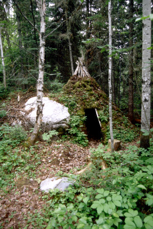 The rapids went around a bend to the right; so we would have to scout them if we wanted to try a run. But the run-or-portage question was somewhat academic because the schedule Larry had worked out for the trip called for us to camp here tonight. We would consider running these rapids only if we couldn't find a suitable campsite. But the first problem was to get ashore. A couple of rock ridges/shelves just below the water's surface forced us to jockey the canoes back and forth to reach a suitable landing on the right bank. Once ashore, we followed the portage trail down to an unusual earth-and-moss covered teepee. Evidently this man-made teepee was, or had been, used for shelter at some point -- perhaps in the colder months. It was nestled in the woods where another trail came in from the left. This second trail led us out to a broad rock outcropping that extended out into the rapids. One section of the outcropping near the woods was flat and smooth enough to suggest a possible campsite. We weren't used to camping on rock, though; so we continued downstream on a trail next to the water that eventually ran back into the portage trail. At the end of the portage trail was a grass-and-sand area with a fire ring -- obviously the "official" campsite for this portage. This site actually had less flat tent space than the rocky outcrop upstream, and there was less breeze here to keep away the bugs. We decided to return to the rocky outcrop and make camp there.
As we erected the tents, we were attended by black flies in enough numbers to bring out our headnets and bug jackets for the first time. Since there was no soil here, Larry and Alan used rocks instead of stakes to anchor Larry's Sierra Designs tent. Larry had acquired this tent only a few months earlier and had tried it out for the first time on a family canoe-camping trip on the Buffalo River at Easter. Meanwhile my Eureka Overlander went up quickly, as usual. With its newly installed zipper in the front door flap and extensive seam-sealing, I was looking forward to the Overlander weathering this trip much better than it had the Chapleau trip the previous year.
After camp was set up, we turned our attention to dinner. A campfire for cooking would normally have been perfect for such a rocky campsite: There was utterly no danger of the fire spreading. But it was getting too late to go around gathering firewood, and we were all tired and hungry. We decided just to cook dinner on the camp stoves. Larry prepared a meal for himself and Alan, while I pulled out my Whisperlite stove to heat water for JD's and my dinner. I hadn't used the Whisperlite since the Chapleau trip the previous year; so I struggled in my attempts to get it going and forgot to use the reflector that would concentrate the heat. Eventually the stove managed to boil enough water for our dinner, but it used up an enormous amount of white gas in the process. I was concerned that I would run out of gas before the end of the trip; but as it turned out, I never used the Whisperlite again, and even the gas, which I was ready to donate to Larry for his stove, never got used because we were able to cook most of our later meals over a campfire.
As we ate in the gathering dusk, the modest breeze gradually died, and the sky grew overcast.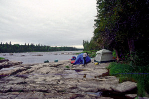 Mosquitoes began to replace black flies as the air became more humid. After dinner, we had a brief period of sprinkles that moistened the tent walls and persuaded everyone to don raingear. But this bit of rain soon stopped, and there was no recurrence the rest of the evening.
Before retiring to the tent, I filtered a couple quarts of water using the new Sweetwater cartridge I had acquired. We had a brief, half-hearted conversation about the possibility of marauding bears getting into our food supplies, but as usual, we were too tired, and it was getting too dark, to go looking for a tree limb suitable for hanging our food bags. We ended up putting all the food packs out on the rocks at water's edge away from the tents.
Once in the tents, we fell asleep quickly to the pleasant rush of the nearby rapids. The hard rock surface beneath the tents was surprisingly comfortable, perhaps because it was so smooth. The temperature hovered in the mid-60's all evening, and the night passed uneventfully.
Incremental Distance: 10 miles
Cumulative Distance: 10 miles
Thursday, June 27 - Day 2
Late departure;
JD's watch alarm woke us at 6:00AM. He lingered in the tent for a while, then exited around 6:45. I worked on the log until around 8:15. The sky was overcast, but there was no sign of rain. The temperature was in the mid-60's, and the air was quite humid. JD wandered around the campsite quietly taking video footage of the local flora and the peculiar patterns in the rock surfaces.
Eventually the rest of us emerged from the tents and began the usual excruciatingly slow first-morning effort of trying to establish some kind of routine for breakfast and for breaking camp. It did not help matters that Larry and I both had headaches. We took our respective pain remedies and then launched into breaking camp. While packing up my stuff, I made the mistake of putting a filled water bottle into my "gear pack". (On this trip, for the first time, I had two full-size river packs. One I used for clothing, sleeping bag, therm-o-rest mattress, and other things I wanted to keep dry all the time. The other I used for gear like the tent, tarps, toilet seat, etc. that I expected to get wet from time to time.)
We finally finished breaking camp around 11:30. Such a late launch did not bode well for our plan to paddle 25 miles that day. When we departed the camp, the weather was about the same as when we had first arisen: overcast sky, temperature about 65o, and almost no breeze. Light conditions were not favorable for spotting submerged obstacles -- a definite drawback because we immediately encountered swifts and riffles just downstream from the camp. JD and I ran into a couple of rocks in this stretch of the river and even got hung up on one briefly.
J. Brown
July, 1996
Edits and Summaries:
L. Walter
February, 2006